DJI Mavic, Air and Mini Drones
Friendly, Helpful & Knowledgeable Community
Join Us Now

View from 400' How much area?

spamgnome

Well-Known Member
Joined
Jan 14, 2019
Messages
771
Reactions
897
This may be an oddball question, but here goes. I'm going to be photographing a mall that's about 25 acres. Some of the shots are going to be nadir (looking straight down). I know I'll need to take several photos so they can be stitched together in post production. As this isn't mapping, the side laps and front laps don't need to be anything like 75%, but probably 20%-ish. In any case, does anyone know of any tools that might give me an indication of how many images I'll need to take? Another way to put this, is "how many square feet can an Air 2 see from 400' up?"
Hoping/thinking there might be a tool or website that could provide this information. Thanks!
 
Take one or two shots from that height, work out what corner objects or recognisable points are in shot, measure the distances between objects in the corners of the shot, work out the area of the shot. With a 20% over lap only 36% of the shot is unique. Divide the total area by 36% of the actual calculated area of one shot.
 
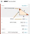
If you know the altitude and viewing angle of the camera, a simple Angle calculator can be used to find the answers you seek fairly close. In your case, an Air 2 has a camera view angle of 84 degrees. Using a right triangle calculator you can plug those numbers in to get the rest. Keep in mind this is a right angle so it will be half of what the full view is. (The triangle is for illustration and is not to scale)

So in your case, the camera with an 84 degree angle at 400 feet AGL (assuming a flat surface) will see from side to side an area of approximately 720 feet (side 'b' x 2). If you know the aspect ratio that your recording in, you can get the the other dimension image (height). For instance if you're recording in a 16 x 9 resolution, divide divide 720 by 16 and multiply that number by 9 to get 405.

So in essence, at 400 feet with a camera view angle of 84 degrees and recording in a 16 x 9 resolution, your final image will show an area of approximately 720' x 405' .

Angle.jpg
 
but the shot is not a square. Let's take the viewing angle as 84 or 42 deg in the X direction What then is the angle in the Y direction? I suppose you might be able to assume the Y length is 3/4 the X length.
 
Last edited by a moderator:
but the shot is not square, let's take the viewing angle as 84 or 42 deg in the X direction What then is the angle in the Y direction?
You don't need the other angle because once you know the width, the 'y' of the picture will be determined by the aspect ratio of the output. So an aspect of 16 x 9 will yield a 720' x 405' image and if the camera is set to a 4 x 3 aspect the resulting image will be 720' x 540' and so on.
 
as mentioned in the edited post (the edit was made 3 minutes before your reply)
 
This may be of some help:
Your true -of-view is likely not exactly as specified, particularly when shooting video.
I realize your question is not about video, but some of the information may still be of use.
 
  • Like
Reactions: Ty Pilot
If you know the altitude and viewing angle of the camera, a simple Angle calculator can be used to find the answers you seek fairly close. In your case, an Air 2 has a camera view angle of 84 degrees.
If I'm reading your solution properly, it looks like you have assumed that the viewing angle is horizontal.
The viewing angle of lenses, including DJI lenses are given as a diagonal angle.

The OP's question can be answered with a FoV calculator like this one:
 
Last edited:
  • Like
Reactions: Ty Pilot
Angle of view ... lol. X or Y or H? It matters how the question is asked; and this is true of any camera/lens combination.

Here's a quick search for a table of values for normal SLR lenses:


pps: keep in mind the actual image mode being used will also affect FOV.
 
Last edited:
If I'm rading your solution properly, it looks like you have assumed that the viewing angle is horizontal.
The viewing angle of lenses, including DJI lenses are given as a diagonal angle.

The OP's question can be answered with a FoV calculator like this one:
Basically, yes. A few years back I did a video where I had to know the distance and I found the method I suggested is fairly accurate, albeit a very simplistic one compared to the calculator you suggest.

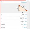
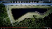
As an example: Below is a scene from the video which is a still photo I took at 400 feet with a Typhoon H. The Typhoon H's specs showed the viewing angle at 94 Degrees. So with that I got the following.

Lake4Tri.jpg

So the horizontal distance seen in the photo below should be 857.9 feet (2 x side b)

TyHlake4.jpg


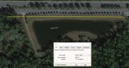
This is from Google Earth, I snapped a ruler to the approximate points in the photo - 859.9 feet. And while this measurement could be said to be inaccurate, we did measure the side walk from where the road cuts down beside the lake on the left to where there is a new pavement line at the right. The google measurement of that distance was within 3 feet of actual distance we measured.

GoogleLake4.jpg
 
Last edited:
Calculating the distance from the height and angle is trigonometry, using the "tangent" of the half angle, see Sine, Cosine, Tangent
You look up the angle and it's tangent" ratio then multiply the height by that ratio.
When I went to school we did this with a book of table, now a days I'd guess most calculators and probably phones have "tables" in their memory.
 
Last edited by a moderator:
Another variable most people ignore is how the actual lens is ground (final focal length) and mounted (focal distance) will also affect FOV. While pretty minor effects, it can be important, especially in macro/micro work.

As for the math, learned to use trig and geometry to figure tree heights and volumes and plot sizes back in a high school forestry class. It's just what we did in Ora-gun, avary boy got a chainsaw an knows how ta chop down the forast.
Juck way to much maths for my old head, left school a millennium ago 😂😁 never been good with maths. I'm as confused as a camilion on a smarty box with all you guys clever examples 👌😁 luckily I just fly and enjoy the view from above.
 
First of all, what drone are you flying? The posts above mention 84 degree FOV, but this is a Mavic forum. Mavic 2 pro for example, is listed as 78.8 degrees, much narrower FOV at 400 ft agl.
Also, traditionally, FOV is the diagonal (as Meta posted), not the side to side.
Anyway, I once did this, I flew to 400agl with Phantom 4 Pro, maneuvered to where I had measurable lines in one corner, and points in the other 3 corners that I could measure on google earth.
I found that the P4P at 400 agl gave me a rectangle photo very close to 400 ft x 600 ft. (photo aspect ratio of 3x2 agrees with these figures.
The diagonal of a 400x600 is about 721 ft, so that would correspond to post #3 Ty Pilot above.
 
Also, if I remember correctly, and without doing any math, I think I also did 100 ft, 200 ft and 300 ft agl, and got photos of 100x150, 200x300, 300x450 respectively. Someone who wants to do the math can verify or correct me.
 
This may be an oddball question, but here goes. I'm going to be photographing a mall that's about 25 acres. Some of the shots are going to be nadir (looking straight down). I know I'll need to take several photos so they can be stitched together in post production. As this isn't mapping, the side laps and front laps don't need to be anything like 75%, but probably 20%-ish. In any case, does anyone know of any tools that might give me an indication of how many images I'll need to take? Another way to put this, is "how many square feet can an Air 2 see from 400' up?"
Hoping/thinking there might be a tool or website that could provide this information. Thanks!
To cover extreme wide shots I attach a Go Pro to my Mavic 2 Pro but I'm not sure if an Air 2 can handle the weight
 
I'm late to this discussion, but this video shows that Pix4d mapping software can adjust the overlapping % when it maps the flight (at 2 min 18 sec of video. Even if you don't use this software to fly the mission, you can use it as a planning tool to get an idea of how many photos you will need, which it seems like what you are after.
 
Lycus Tech Mavic Air 3 Case

DJI Drone Deals

New Threads

Forum statistics

Threads
131,080
Messages
1,559,620
Members
160,064
Latest member
djiuserjohn