DJI Mavic, Air and Mini Drones
Friendly, Helpful & Knowledgeable Community
Join Us Now

Which app for LAANC

jayarr

Member
Joined
Dec 23, 2021
Messages
17
Reactions
21
Location
Michigan
New pilot with mavic mini. I see three apps, seemingly all for flight approval.
B4UFLY, Aloft, and Airmap.
As a recreational flyer who is unregistered with FAA, is any one of these the simplest solution?
I’m in rural northern Michigan but do have many state parks, state forests, etc.
Planning on a winter vacation to Florida near Cape Canaveral, so will probably need authorizations to fly.
Any suggestions are appreciated.
Now that AirMap has been absorbed by a reputable company I recommend it’s use. Getting LAANC authorization is very easy in this app. It is also a breeze to use the search function and setup a flight for the future without actually being physically located there.

While Aloft is good, it is location centric and is a major pain to use. B4UFLY is the little brother of Aloft and does not allow you to apply for LAANC approvals, it sends you to Aloft to do that.

Being in Michigan you will find that flying in state parks will normally be no problem, except for Mackinac Island. Drones spook the horses and detract from the 1800’s theme.
 
New pilot with mavic mini. I see three apps, seemingly all for flight approval.
B4UFLY, Aloft, and Airmap.
As a recreational flyer who is unregistered with FAA, is any one of these the simplest solution?
I’m in rural northern Michigan but do have many state parks, state forests, etc.
Planning on a winter vacation to Florida near Cape Canaveral, so will probably need authorizations to fly.
Any suggestions are appreciated.
I'm not sure what you mean by "unregistered with FAA", but you do know that you need at least a TRUST certificate even if you only fly recreationally? See https://www.faa.gov/uas/recreational_fliers/knowledge_test_updates/
 
  • Like
Reactions: BBartol
Now that AirMap has been absorbed by a reputable company I recommend it’s use. Getting LAANC authorization is very easy in this app. It is also a breeze to use the search function and setup a flight for the future without actually being physically located there.

While Aloft is good, it is location centric and is a major pain to use. B4UFLY is the little brother of Aloft and does not allow you to apply for LAANC approvals, it sends you to Aloft to do that.

Being in Michigan you will find that flying in state parks will normally be no problem, except for Mackinac Island. Drones spook the horses and detract from the 1800’s theme.
Thanks, this is what I wanted.
 
I would also recommend and do use myself Airmap. Its the easiest to follow. Aloft is nice as well, more robust with weather data and extras that I dont need via the app when all I want to do is a quick request to fly.
 
  • Like
Reactions: jayarr
Now that AirMap has been absorbed by a reputable company I recommend it’s use. Getting LAANC authorization is very easy in this app. It is also a breeze to use the search function and setup a flight for the future without actually being physically located there.

While Aloft is good, it is location centric and is a major pain to use. B4UFLY is the little brother of Aloft and does not allow you to apply for LAANC approvals, it sends you to Aloft to do that.

Being in Michigan you will find that flying in state parks will normally be no problem, except for Mackinac Island. Drones spook the horses and detract from the 1800’s theme.

Aloft defaults to your current location, but it's simple to examine any location.

Under Flight Deck, click the Maps button and then touch the map that opens to specify the location. This may be a new feature. I remember being frustrated by the fixed location last summer.
 
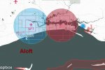
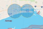
I've noticed that AirMap and Aloft don't show the same LAANC availability for some locations. For example, Aloft says that LAANC is not available around Keesler AFB, KBIX. AirMap offers LAANC authorizations. I saw something similar last summer in New Orleans.

I have both apps on the phone and while I prefer the interface on Aloft, I use AirMap when it provides better LAANC coverage.
 
Last edited:
I've noticed that Airdata and Aloft don't show the same LAANC availability for some locations. For example, Aloft says that LAANC is not available around Keesler AFB, KBIX. Airdata offers LAANC authorizations. I saw something similar last summer in New Orleans.

I have both apps on the phone and while I prefer the interface on Aloft, I use Airdata when it provides better LAANC coverage.

AirData or AIRMAP?
 
  • Like
Reactions: MS Coast
Update on Airmap's handling LAANC at Keesler AFB/KBIX

It turns out that LAANC approvals are not available at this location. Airmap just fails to show the entire controlled airspace grid as being unavailable for LAANC on the chart.

Instead, Airmap displays both available and unavailable LAANC grids in the same way. Aloft shows LAANC grids in red so that they're identified as unavailable right away. Airmap lets you go through the process of specifying a route and documenting the details and then tells you that the location is unavailable for LAANC authorization. Messy.

airmap.jpg aloft.jpg
 
  • Like
Reactions: jayarr
Update on Airmap's handling LAANC at Keesler AFB/KBIX

It turns out that LAANC approvals are not available at this location. Airmap just fails to show the entire controlled airspace grid as being unavailable for LAANC on the chart.

Instead, Airmap displays both available and unavailable LAANC grids in the same way. Aloft shows LAANC grids in red so that they're identified as unavailable right away. Airmap lets you go through the process of specifying a route and documenting the details and then tells you that the location is unavailable for LAANC authorization. Messy.

View attachment 141278 View attachment 141279
That is odd, because AirMap used to
show a difference between grids that were covered by LAANC and those that were not on the system yet. Many military bases have grids, but are not on the LAANC system because it takes an approval from military sources.
 
New pilot with mavic mini. I see three apps, seemingly all for flight approval.
B4UFLY, Aloft, and Airmap.
As a recreational flyer who is unregistered with FAA, is any one of these the simplest solution?
I’m in rural northern Michigan but do have many state parks, state forests, etc.
Planning on a winter vacation to Florida near Cape Canaveral, so will probably need authorizations to fly.
Any suggestions are appreciated.
Welcome to the wonderful world of UAS and this fantastic forum. Step 1: as a new drone owner is to visit: . Register/label your drone and take the (impossible to fail) TRUST exam. Keep copies of both with you at all times while flying. Ask questions of any uncertain drone subject on this forum. Step 2: fly and have fun! Start small, gain confidence, work your way up! Learn all you can about flying/controlling your drone. Please refer to the FAA.GOV website for much more data on safe UAS operations.
Good luck and above all, have fun!
 
  • Like
Reactions: MA2 317 and BigAl07
New pilot with mavic mini. I see three apps, seemingly all for flight approval.
B4UFLY, Aloft, and Airmap.
As a recreational flyer who is unregistered with FAA, is any one of these the simplest solution?
I’m in rural northern Michigan but do have many state parks, state forests, etc.
Planning on a winter vacation to Florida near Cape Canaveral, so will probably need authorizations to fly.
Any suggestions are appreciated.
I see you plan to be in Florida near the Cape. Be sure to check for TFR’s before flying in that region. A 30nm radius TFR goes into effect whenever launch activities are on the agenda there. I know AirMap usually shows them, but you can also check here Federal Aviation Administration - Graphic TFR's
 
  • Like
Reactions: MA2 317 and jayarr
Does OpenSky allow requests for only circular operation areas with a variable radius? It appears that there's no way to enter a flight path rather than just a circle.
MS, yes, I guess it does only allow for a circular area to submit for approval. I agree, the ability to manually drag the requested area permiter points would be a better option.
 
Lycus Tech Mavic Air 3 Case

DJI Drone Deals

Forum statistics

Threads
130,932
Messages
1,557,999
Members
159,935
Latest member
MacPilot55