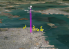
DJI Mavic, Air and Mini Drones
Friendly, Helpful & Knowledgeable Community
Join Us Now

Yet another Virtual Litchi Mission (Chrome/Firefox Extension)

Thanks for your help. The path seems to run correctly now except the orientation of the drone should not be forward, but rotated outwards towards the Lake. Thats not happening.
Video is not playing.
 
Sorry for late reply. You need to choose "Virtual mission" as marked on screenshot below.
yavlmge1.png
 
This extension is freakin' awesome. I took the whole Phantom Film School training on VLM only to realize its Windows only. I'm a Mac user. So I was stoked to see this post by Bazuchan.

I've got a complicated mission I've planned over and around a state capital that I really wanted to run in VLM before I flew it for real. The last thing I need to do is fly my Mavic 2 into a government building. I'd downloaded the Litchi 3D KML and looked at it in Google Earth Pro. That's good, but it's not the same is flying the mission.

Bazuchan's Chrome Litchi Virtual Mission fits the bill. I've experienced the same below ground issue between a couple of waypoints that Mosvold described. But outside of that one small item, I am very gratified to have come across this extension.

Thank you Basuchan.
 
I would love to share the mission with you, but I'm not smart enough to attach a KML file. All my KML files are greyed out when I try to attach.
You can make the mission public in Litchi Hub and then share the URL.
 
When you design your Waypoints mission in the comfort of your easy chair using Litchi Mission Hub - Mission Hub - Litchi - be sure to click inside the "Above ground" box when you set altitudes. Otherwise, the altitudes of each waypoint will be calculated from your launch position. Then, if you were to fly up-hill, the drone would not realize it is much closer to the ground than the altitudes you meant it to fly at. Here's what that looks like:
YIKES!
 
  • Like
Reactions: FL AV8R
Wow. Consistently amazed by the talent and skills of the folks in this forum. Great job!
 
Hello, Bazuchan, I have been using Chrome VLM for a year, thanks for your excellent work! but recently the elevation is wrong much higher Than the actual. I reinstalled Chrome, I deselected terrain but still failed and I have read #23 to change the file to relative to ground but I don't know how to do it, can you please help? Thanks so much! Rex
 

Attachments

  • Screen Shot 2019-05-02 at 1.46.33 PM.png
    Screen Shot 2019-05-02 at 1.46.33 PM.png
    2 MB · Views: 24
Hello, Bazuchan, I have been using Chrome VLM for a year, thanks for your excellent work! but recently the elevation is wrong much higher Than the actual. I reinstalled Chrome, I deselected terrain but still failed and I have read #23 to change the file to relative to ground but I don't know how to do it, can you please help? Thanks so much! Rex
Editing file should not be needed. Could you share the missing so I could look?
 
What DEM file or settings are you guys using with GE for planning missions? Is the default good enough for flight or is anyone importing a separate higher resolution one?
 
Lycus Tech Mavic Air 3 Case

DJI Drone Deals

New Threads

Members online

Forum statistics

Threads
131,052
Messages
1,559,316
Members
160,031
Latest member
kcb2627