DJI Mavic, Air and Mini Drones
Friendly, Helpful & Knowledgeable Community
Join Us Now

Guess Which Pics are Over 400ft and which are under 400ft. Taken with Mav3 @ 28x Zoom

Don Testme

Well-Known Member
Joined
Sep 8, 2021
Messages
571
Reactions
600
Age
48
Location
Ontario, CA
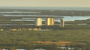
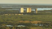
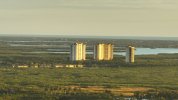
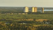
These pics are from a MAV3 taken with the zoom lens at 28x. A simple observer can tell which pics are at a higher altitude than the next. This post isn't what they call, umm. What is it called? Umm. Whatever, internet people call it. I'm just curious to see at which pic some viewers believe the photo is taken at too high of an altitude according to regs, and which ones are in accordance with regs. EXIF/Metadata has been removed to keep you from cheating. Good Luck. Again, this post isn't a whatchamacallit. Happy Halloween Everyone.
 

Attachments

  • DJI_0034.JPG
    DJI_0034.JPG
    1 MB · Views: 44
  • DJI_0035.JPG
    DJI_0035.JPG
    1.1 MB · Views: 41
  • DJI_0036.JPG
    DJI_0036.JPG
    981.4 KB · Views: 41
  • DJI_0037.JPG
    DJI_0037.JPG
    1.1 MB · Views: 42
The camera heights can be approximated with a few assumptions. Firstly, the height of the buildings is required - appear to be 22 storey residential which would, on average, be around 300 ft. Secondly, a probably reasonable assumption that the terrain is all around sea level.

That allows the observation that 0037 was taken at approximately building height since the top of the building lines up with the horizon, which would be 300 ft. Measuring the horizon offsets in the other images would suggest that 0036 was around 450 ft, 0035 was 600 ft, and 0034 was at 750 ft. The margins of error are not insignificant though.
 
  • Like
Reactions: BigAl07
The camera heights can be approximated with a few assumptions. Firstly, the height of the buildings is required - appear to be 22 storey residential which would, on average, be around 300 ft. Secondly, a probably reasonable assumption that the terrain is all around sea level.

That allows the observation that 0037 was taken at approximately building height since the top of the building lines up with the horizon, which would be 300 ft. Measuring the horizon offsets in the other images would suggest that 0036 was around 450 ft, 0035 was 600 ft, and 0034 was at 750 ft. The margins of error are not insignificant though.
Your very close. All your measurements were good. Just off by about 55ft to high. Basically 36 and 37 were within regs and 34 and 35 were out. You are a very astute observer.
 
  • Like
Reactions: sar104
Your very close. All your measurements were good. Just off by about 55ft to high. Basically 36 and 37 were within regs and 34 and 35 were out. You are a very astute observer.
Okay - with the assumptions required I was probably lucky to be that close.
 
  • Love
  • Like
Reactions: lorpal and BigAl07
Lycus Tech Mavic Air 3 Case

DJI Drone Deals

New Threads

Forum statistics

Threads
131,275
Messages
1,561,532
Members
160,226
Latest member
RWShepard