DJI Mavic, Air and Mini Drones
Friendly, Helpful & Knowledgeable Community
Join Us Now

Mavic 2 Pro accuracy

Lambda

Well-Known Member
Premium Pilot
Joined
Dec 6, 2021
Messages
48
Reactions
26
Age
68
Location
Australia
Mavic 2 Pro, RC controller accuracy

I have a client wanting me to do some pre-construction photos, and she wants to know how accurate, longitude/lat and Height the standard drone can be flown at
If she gives me a distance from boundaries, and height how close can I get to that?

I hope this makes sense

Thanks
 
I'm not sure exactly exactly, but I would be willing to bet you would be able to program Litchi or Drone Link in your computer. Litchi and Drone Link both allow you to fly the mission virtually on your computer before going into the field. The only drawback with Litchi and the M2P is that the camera FOV is different in the camera than it is on the program so your have to allow for that. I always like to test the areas that I have jobs in because gremlins, like geofencing, can pop up on the live shoot and spoil your day.

I haven't programmed Litchi by Long/Lat, but height is easy and you can certainly come up with a reasonable approximation. One benefit of programming an autonomous mission is that you can store it and as the project goes on you can just re-fly it as many times as you like. If it were me, I'd do just that, do a test flight filming with caption on and review it in VLC player which will tell you where you are in Lat/Long.

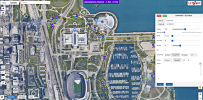
Below is a screen shot of one of my missions. Note that it does have Lat/Long for each waypoint.

1654651851436.png
 
I'm not sure exactly exactly, but I would be willing to bet you would be able to program Litchi or Drone Link in your computer. Litchi and Drone Link both allow you to fly the mission virtually on your computer before going into the field. The only drawback with Litchi and the M2P is that the camera FOV is different in the camera than it is on the program so your have to allow for that. I always like to test the areas that I have jobs in because gremlins, like geofencing, can pop up on the live shoot and spoil your day.

I haven't programmed Litchi by Long/Lat, but height is easy and you can certainly come up with a reasonable approximation. One benefit of programming an autonomous mission is that you can store it and as the project goes on you can just re-fly it as many times as you like. If it were me, I'd do just that, do a test flight filming with caption on and review it in VLC player which will tell you where you are in Lat/Long.

Below is a screen shot of one of my missions. Note that it does have Lat/Long for each waypoint.

View attachment 149620
Thanks for the reply
I have paid for DroneLink, but am still going through the UDEMY course, so I will use this
 
Lycus Tech Mavic Air 3 Case

DJI Drone Deals

New Threads

Forum statistics

Threads
131,552
Messages
1,564,098
Members
160,445
Latest member
espinafre