DJI Mavic, Air and Mini Drones
Friendly, Helpful & Knowledgeable Community
Join Us Now

Foresteraustin

New Member
Joined
May 14, 2024
Messages
3
Reactions
3
Age
28
Location
Washington
Hello everyone, I was using a Mavic 2 at work and it lost connection and disappeared.

I think I put it in a tree, but also may have flown during a solar storm causing it to disconnect. It took a couple tries to recalibrate the compass, and even had to land twice to redo it. The incident happened on 5/10 about 10am in Washington state.

I was using DroneDeploy to run a flight plan.

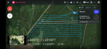
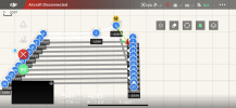
The attached photos are a screenshot from both DJI and DroneDeploy.
I find it odd that they both show different distances and different areas that the drone was last connected.
In the DJI screenshot I moved to the west in hopes that it would reconnect, hence my little blue bubble being where it is.

Here is the flight log for the last flight: I don't understand why the flight log does not match up with the flight shown in DroneDeploy.

Does anyone have any ideas to help me pinpoint where exactly I should be searching for this thing?DroneDeploy Lost.PNGDJI Lost.PNG
 
  • Like
Reactions: RodPad
I don't understand why the flight log does not match up with the flight shown in DroneDeploy
Your drone didn't really fly the path shown in your first screenshot above. The downlink dropped in yellow box and reconnected on the right side of the yellow bow -- where it starts to follow the programmed flight path again.

1715728391634.png


Does anyone have any ideas to help me pinpoint where exactly I should be searching for this thing?
Try following the programmed flight path after the point where it ends in your first screenshot above. Perhaps the drone crashed into a tree along that path somewhere.
 
Hello everyone, I was using a Mavic 2 at work and it lost connection and disappeared.
This wasn't a case of loss of connection.
It's a case of loss of power.
When the drone loses power, there is no connection so the screen will show connection lost.
I think I put it in a tree, but also may have flown during a solar storm causing it to disconnect. It took a couple tries to recalibrate the compass, and even had to land twice to redo it. The incident happened on 5/10 about 10am in Washington state.
It's unlikely that the solar storm had anything to do with the incident.
The compass calibration issue definitely had no impact.
Does anyone have any ideas to help me pinpoint where exactly I should be searching for this thing?
We can eliminate some of the usual suspects.
At the end of the flight data the battery was showing plenty of juice.
Wind was low,
Your drone was high enough to be clear of any trees or obstacles.
The pitch, roll and yaw data show no indication of a collision.

The likely cause of the loss of your drone is a sudden loss of power.
Flight data for the mavic 2 series does not show the number of charge cycles on the battery.
But it shows the full capacity of your battery as 3402 mAh, which is 86% of the capacity of a brang new mavic 2 battery.
This suggests the battery was in far from new condition.
If it had been swollen, this can lead to the battery not seating properly and more easily subject to disconnection.

The point at which the power disconnected was 47.21762 -121.76309.
But the drone was flying west at 18 mph so the drone would have fallen a little further to the west of this point.
Looking at the aerial image of the site, it's quite possible that the drone is hung up in a tree.
 
Does anyone have any ideas to help me pinpoint where exactly I should be searching for this thing?
A rough calculation indicates the drone could be about 230 ft further east than the last recorded location.
That is at approx 47.21756 -121.76331 if the drone fell to the ground without hitting trees on the way down..
If the drone crashed into trees on the way down, it would probably be somewhere east of that point.
 
Your drone didn't really fly the path shown in your first screenshot above. The downlink dropped in yellow box and reconnected on the right side of the yellow bow -- where it starts to follow the programmed flight path again.

View attachment 175045


Try following the programmed flight path after the point where it ends in your first screenshot above. Perhaps the drone crashed into a tree along that path somewhere.
Shoot I see what you mean, I will walk that path and see what comes of it. Thank you for your input!
 
  • Like
Reactions: RodPad
A rough calculation indicates the drone could be about 230 ft further east than the last recorded location.
That is at approx 47.21756 -121.76331 if the drone fell to the ground without hitting trees on the way down..
If the drone crashed into trees on the way down, it would probably be somewhere east of that point.
I didn't realize it was a loss of power, this makes me feel a little better. I will go to this point and search. Thank you so much!
 
  • Like
Reactions: RodPad
I didn't realize it was a loss of power
It was likely either that or the drone disconnected from the remote controller, continued flying the waypoint mission, and crashed somewhere along that route.
 
  • Like
Reactions: RodPad

DJI Drone Deals

New Threads

Forum statistics

Threads
131,814
Messages
1,566,612
Members
160,679
Latest member
ralph.smith.mckenzie@gmai