DJI Mavic, Air and Mini Drones
Friendly, Helpful & Knowledgeable Community
Join Us Now

Curious about the exact function of the bottom infrared sensors.

mattitech07

Well-Known Member
Joined
Aug 21, 2020
Messages
106
Reactions
108
Location
IT
I have an Air 2, and from what I know so far, the TOF sensors on the bottom of the drone are part of the vision system (as DJI refers to them in the manual) and scan the ground for eventual obstacles. And the infrareds are technically for height measurement.

But I don't really know anything else about the infrareds and I'm curious to know what is their exact purpose, why are the infrared sensors paired with the TOF on the bottom of the drone? What function does each couple of sensors have? So this thread is just about me being curious.
 
  • Like
Reactions: Torque
DJI Air 2/2S features both an Infrared Sensing System and Forward, Backward, Upward, and Downward Vision Systems, allowing for hovering and flying indoors as well as outdoors and for automatic Return to Home.
 
  • Like
Reactions: Mavikhan
they simply tell the IMU the height of the drone above the ground ,but there is a distance limit to their ability to do so ,and they can be fooled by reflective surfaces such as water, normally in drone use its around 10 to 15 feet ,from the surface below the drone ,after that they play no further part in establishing a height reading,very similar to the echo location a bat uses to tell its distance from objects ,they use sound ,IR uses light in the infrared part of the spectrum
 
Last edited:
DJI Air 2/2S features both an Infrared Sensing System and Forward, Backward, Upward, and Downward Vision Systems, allowing for hovering and flying indoors as well as outdoors and for automatic Return to Home.
Are you certain the horizontal OA uses IR?
I thought they were visible light only, hence the warnings we get in flights in poor light.
To be honest my understanding of the bottom IR stuff is the same as OMM's
 
  • Like
Reactions: old man mavic
And the infrareds are technically for height measurement.


Primarily for landing.

Ever noticed how the aircraft stops for a second and possibly rise a bit before touchdown.

That's the IR doing it's thing.

The onboard barometer determines the height when flying.
 
the optical sensors require a certain amount if light to function correctly ,and ideally they need a pattern of contrasting colours, to be able to optically distinguish between different areas
its not the vision system that causes the drone to suddenly dive into water ,but the fact that the receiving IR sensor cannot get a sensible return reading from the reflective surface below
because of the inaccuracy of the barometer ,that alone would not tell the drone its exact height from the surface below ,and without the IR sensors then it would be very hit and miss when it comes to landing
 
  • Like
Reactions: AZDave
What function does each couple of sensors have?
The infrared sensors (the ones that are more to the rear, that are very reflective) are the TOF sensors used to measure height. They are used for precision landing and bottom obstacle avoidance, that prevent you from slamming the drone into the ground when pushing the stick fully down even in sport mode. These can be easily confused by reflective surfaces such as mirrors, glass tables, car roofs and water, so be careful not try to land on one of those, and if you do, do not push the left stick fully down as the sensors might fail and the drone might fly into the surface at full speed.

The other sensors on the bottom (2 of them, on each side of the aux light, the ones that look the same to the obstacle avoidance sensors on the front and back) are VPS cameras, those are used for precision landing (hover 6m high for about 5 seconds after takeoff to activate precision landing) which accurately lands your drone in the (nearly) exact spot you took off from when using RTH mode. Those are also used for stabilizing the drone in non-GPS environments. If you have ever hovered indoors, you might have noticed that if enough light is present, and the floor below the drone is recognizable enough (with some patterns) then the drone might very accurately hold its position. That is called OPTI mode or Visual Positioning mode, it is automatically used if GPS is not available, however it only works up to 7 meters high. These cameras are used to track the visual movement of the surface below the drone, thus accurately knowing where it's drifting and correct that. If the sensors nor GPS are available, then the drone will be in ATTI mode, or No Positioning mode, the drone will drift away with the wind.

Note that the sensors do not work when flying higher than a certain altitude, in the Air 2 it is around 7 meters, so they will be disabled when flying higher and not be used, they are used during takeoff and landing, and when GPS is not available.
 
Last edited:
  • Like
Reactions: Yorkshire_Pud
What is TOF?
Check this out: Time-of-flight camera - Wikipedia
It is a way to measure the distance between (in this case) the drone and an obstacle using (in the Air 2's case) infrared sensors. This doesn't create a 3D map like the vision cameras used for obstacle avoidance in the front and back of the aircraft, instead TOF gives the distance in 1D, in the case of the Air 2, as the TOF are on the bottom, it indicates only the height. They only work until a certain altitude, in most DJI drones this is 7 meters.

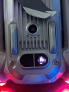
In short, the way it works is that it sends a pulse of light using a LED, and measures how much time it takes for the light to get back to the sensor. But in contrast to regular LEDs, you cannot see this light with your eyes (only just a bit in the dark if directly looking at it while the drone is hovering low enough for it to be active), as it is infrared, but if you try to point your phone's camera you will see it as seen in this photo below:

Infrared_Mavic_Air2.jpg
 
Are you certain the horizontal OA uses IR?
I thought they were visible light only, hence the warnings we get in flights in poor light.
To be honest my understanding of the bottom IR stuff is the same as OMM's
I just copied and pasted this from somewhere. I'll have to find it again. If the information is wrong, just disregard it.
 
I just copied and pasted this from somewhere. I'll have to find it again. If the information is wrong, just disregard it.
actually the info you posted is not technically wrong the drone does have different sorts of sensors but they do different jobs during flight ,its just the way the info was worded that could be confusing
 
Infrared can work at night while the OA sensors need much higher ambient light to work, so it's an intelligent design to put a redundant IR sensor on the bottom in order to prevent crash landings.
 
I have an Air 2, and from what I know so far, the TOF sensors on the bottom of the drone are part of the vision system (as DJI refers to them in the manual) and scan the ground for eventual obstacles. And the infrareds are technically for height measurement.

But I don't really know anything else about the infrareds and I'm curious to know what is their exact purpose, why are the infrared sensors paired with the TOF on the bottom of the drone? What function does each couple of sensors have? So this thread is just about me being curious.
The infrared sensors are TOF (Time of Flight) sensors. No, it's not measuring how long the drone has been flying. It's measuring how long it takes for the infrared signal from the emitter to "fly" to the ground and bounce back to the receiver. From that it knows the exact distance to obstacles below the drone.

But what does the drone actually do with that information? I don't have an Air 2, but I did a series of videos with my Mavic Mini to illustrate that it apparently does absolutely nothing with that infrared height measurement, unless anything is detected within 2ft (0.5m) of the bottom of the drone.

Yes, it is always actively measuring and recording VPS height in the flight log whenever the infrared sensors are within working range, sometimes up to 45ft height. But there is never any apparent response from the drone to that measurement, unless it's within 2ft of an obstacle or ground.

See this thread for previous discussion with videos.
mavicpilots.com/threads/yes-landing-protection-can-be-disabled-but.134162/
 
But there is never any apparent response from the drone to that measurement, unless it's within 2ft of an obstacle or ground.
Very good explanation, except that the sensors also slow autolanding from about 30 feet.
 
Last edited:
  • Like
Reactions: Zbip57
its quite easy to tell when the IR sensor is actually gauging the drones height above the ground ,along the bottom of the screen where it shows height speed distance ,there are two height or H icons one is the height above the home point from the barometer reading, and over to the right of the screen the other one is from the IR sensor
it shows N/A when the drone is on the ground but powered up ,
but once you either do a manual take off or use the auto take off to power up the motors ,it will show a reading once the drone is airborne
the moment the drone goes higher than the IR sensor can detect the surface below ,then the reading will revert to N/A ,until such time ,that you lower the drone into the detection range of the IR sensor again
that tells me that probably the sensor shuts down during flight ,if it cant detect a return signal because it is out of range
 
  • Like
Reactions: Walleye Hunter
[...] there are two height or H icons one is the height above the home point from the barometer reading, and over to the right of the screen the other one is from the IR sensor.
Unfortunately that useful feature is not included in the DJI Fly app. It was there for my Phantoms, but not for my Mini.

It's actually quite useful to have that display. You could be flying your drone high above the ground, then passing over a tree. If the IR sensor is within range of the treetop, the app would show you exactly how much clearance remains between the drone and the top of the tree.

With my Mini there is no such IR height display within the Fly app. I can only find out what the actual VPS height was afterward by downloading the flight log, as it is displayed there. In flight I have to rely only on the camera view to determine whether the drone is high enough to clear the tree.
 
  • Like
Reactions: old man mavic
@Zbip57 just goes to show your never to old to learn
just turned on the RC and Mini 3 and you are right it only gives one Height reading
i flew 4 batteries through my MPP on Good Friday and thats what i was thinking of when i wrote that post you cant beat the old GO4 app
 
  • Like
Reactions: Zbip57
I wrote DJI and this is the official response from them
"Hi there. Thank you for bringing this inquiry to us. The Infrared sensor can detect altitude, so it will use with the downward vision system. Also, these sensors use infrared technology to detect obstacles and avoid collisions, making the drone safer and easier to fly. Hope this helps. Thank you for your valued support."
 
Lycus Tech Mavic Air 3 Case

DJI Drone Deals

New Threads

Forum statistics

Threads
131,150
Messages
1,560,408
Members
160,123
Latest member
suretybondsa