DJI Mavic, Air and Mini Drones
Friendly, Helpful & Knowledgeable Community
Join Us Now

First Flight...aborted

mreco99

Well-Known Member
Joined
Feb 28, 2022
Messages
55
Reactions
21
Age
54
Location
Norfolk
Thought I was all ready to go, watched too many beginners videos, weather, wind all fine, location sorted, checks done, firmware updated, pre flight check list all sorted, satellites 21, signal good, etc etc.
So I get out there all ready to 'maybe' fly, all on and connected fine. but no map on the screen, just white where the map should be. DOH.
Didnt risk taking off as a newbie, came home lol. Was only about 15min away so no big deal.

So now I find out you can download the maps offline, selected all of Norfolk UK was about 3mb. actually it's only going to download the little white square on the screen. Will this download all the layers of the map, ie satellite images too?
Is a good way to test this, to turn off wifi on the controller and see if I still get maps?
Cant believe the tiny area that you can download, one at a time.

Looks like the satelite view with wifi is a lot more detailed than the downloadable maps, for me anyway.

Just might save another noob a wasted trip.


One other thing, can I turn the start up sound down a bit, it's pretty loud.
UPDATE: just found out you can swipe down from the top and theres settings there, inc sound, nice

Just another thing, the drone gets quite warm when it's sat powered on, surprisingly.
And just discovered that the firmware on the drone also has an update waiting, tried that and half way through it failed as the drone was too warm lol. So guess need to do that when it's first turned on.

Thanks people.
 
Last edited:
  • Like
Reactions: old man mavic
@mreco99 couple of things in regards to your post above ,to prevent the drone from shutting down during updates have a fan blowing over the drone to help keep it cool
having the map displayed or not will not make any difference to your ability to control the drone, if you have checked the flight area, before by using one of the Apps ,such as drone assist, then you will know if there are any restictions in the area you intend to fly at
you will need to keep the drone in VLOS anyway, so you will be able to know its position, the most important thing to remember, is getting a good GPS lock, and not taking off untill that has been established ,the little map will not show anything untill this has happened
 
  • Like
Reactions: MotoSavy
thanks old man, can you give me some more info on the 'good GPS lock' part? the little map had nothing on it the whole time.
 
  • Like
Reactions: old man mavic
you will get an audio and visual message saying " home point updated"and also across the top off the screen the GPS icon will turn white this usually happens when the SAT count reaches 12 or so and at the top of the screen will appear a message saying take off permitted
 
  • Like
Reactions: mreco99
you will get an audio and visual message saying " home point updated"and also across the top off the screen the GPS icon will turn white this usually happens when the SAT count reaches 12 or so and at the top of the screen will appear a message saying take off permitted
ahh perfect, I did get that ok, thanks
If we had no satellites (I dont know, maybe the sun flares took them all out), how would this affect flying the drone? would it still work ok, except we would be totally flying manually.? or would the drone just crash.
 
  • Like
Reactions: old man mavic
@mreco99 did you notice that when you first turned on the drone and RC that while waiting for the Sats to lock on there was a message that said fly with caution ,well if you had taken off then ,you would have basically been in Atti mode, and the drone would have drifted with the wind ,and it would not know its position relative to its home point ,so RTH would not function
also when moved in a particular direction, and the sticks were centered, it would still keep going in that direction,for some time, untill an oposite stick movement was made this is in still air of course
on earlier drones ,taking off without a good GPS lock, also meant, that when eventually a GPS lock was established ,then it would confuse the IMU data,from the various sensors, and often result in the drone doing something called Toilet bowling where it just flew uncontrolably ,untill it crashed or hit something
flying in Atti mode is ok as long as you have a clear visual line of sight on the drone ,so you can prevent it from making contact with something in its surroundings ,this sort of scenario could happen if you were flying low down in a valley ,where the topography prevented enough sats to be seen by the drone ,then it would go into Atti mode ,thankfully with the advances made in the systems, that our drones now use for navigation ,then these things are a lot less common now
 
  • Like
Reactions: Pinyoro and mreco99
thanks old man, can you give me some more info on the 'good GPS lock' part?
There is no magic number of sats that ensures you are in GPS mode and ready to fly.
Watch the satellite icon (top of screen) and see it change colour from red to yellow and then when it turns white, the drone will have good GPS location data and will have recorded a homepoint.
i-htZ7Xwq-M.jpg

The number of sats when the icon changes to white is quite variable.
the little map had nothing on it the whole time.
You won't get the map to show unless you have an internet connection for the controller to download the relevant map for where you are.
But don't worry about it.
The map isn't necessary at all (I haven't used it for years).
I find the radar display is more useful and gives me all I need for navigation.
i-SxWV59Q-S.jpg

If we had no satellites (I dont know, maybe the sun flares took them all out),
Unless you fly in the middle east where GPS jamming is a thing or in a deep forest or somewhere else where the skyview is blocked by obstructions, you won't ever have this problem.
There will always be many more sats than you need.
how would this affect flying the drone? would it still work ok, except we would be totally flying manually.?
The drone would fly normally, but it wouldn't have horizontal position holding, it wouldn't have brakes and would be subject to drifting with the wind.
You would have to control it differently and if you weren't familiar with this, it would seem strange.
Without GPS the drone would be incapable of RTH.

or would the drone just crash.
No ... you could fly as long as the battery lasted .. if you were careful.
Not recommended close to obstacles.
 
And just discovered that the firmware on the drone also has an update waiting, tried that and half way through it failed as the drone was too warm lol. So guess need to do that when it's first turned on.
use a fan to blow air onto the drone whenever you turn on the drone while it is stationary. the little USB fans are great for this.
 
  • Like
Reactions: mreco99
Thanks guys, fabulous info.
When I flew a little helicopter (and I mean hand sized), it had no GPS to hold it in place, and was very tricky. Not that I would, but flying the drone without gps sounds like a fun challenge.
 
I wouldn't be particularly worried about not having a map, I think I have only used the map a few dozen times in somewhere around 2000 flights. It was nice to have it I would say it is not essential.
 
  • Like
Reactions: mreco99
I wouldn't be particularly worried about not having a map, I think I have only used the map a few dozen times in somewhere around 2000 flights. It was nice to have it I would say it is not essential.
I took often fly without a map. As long as you maintain VLOS, you really don't need it.
 
  • Like
Reactions: mreco99
thanks guys, makes sense now, at the time, I didnt know if it had any impact.
 
@mreco99, you ARE aware that flight abortion is illegal in the UK simply because there's no map displayed.

You can only abort a flight if you're at risk of losing the drone.

😁😁😁😁😁😁😁😁😁😁😁😁
 
  • Haha
Reactions: mreco99
There is no magic number of sats that ensures you are in GPS mode and ready to fly.
Watch the satellite icon (top of screen) and see it change colour from red to yellow and then when it turns white, the drone will have good GPS location data and will have recorded a homepoint.
i-htZ7Xwq-M.jpg

The number of sats when the icon changes to white is quite variable.

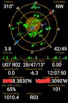
Spot on. The accuracy of the location fix is highly dependent on the arrangement of satellites in view. Roughly the more spread out they are over the sky hemisphere the faster you will get a lock with fewer satellites.

There are accuracy values that can be calculated for GPS called HDOP, VDOP, and PDOP. When HDOP or PDOP achieve a certain precision, DJI declares a lock.

So you can have a lock with 12 satellites, yet not get one with 20 if the configuration in the sky doesn't produce a low enough calculated dilution of precision.

I've been using an app on android forever called GPS Status and Toolbox to view satellite data. Here's the basic display, showing the satellite locations overhead:

1000017550.jpg
 
Last edited:
Lycus Tech Mavic Air 3 Case

DJI Drone Deals

New Threads

Members online

Forum statistics

Threads
131,366
Messages
1,562,432
Members
160,295
Latest member
dochavez1986