What is going on with Offline Maps? I just can't seem to get a straight answer anywhere.
I am flying both a Mavic 3 pro with RC Pro remote, and a Mini 4 pro with RC2.
Both have SD cards more than capable of holding plenty of data.
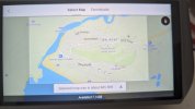
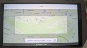
When I go to download an offline map, sure I can "select" an area to download (image one below) BUT when I select it from the downloaded section, the I only am able to see a snippet of what I've actually downloaded (image 2).


I'm also stumped by the need for an SD card: both my controllers save the maps to the RC and NOT the SD card (despite me selecting storage to BE the SD card).
Finally: is there really a need to download offline maps, when anywhere you view before downloading is "cached" for a short period? When I connect to my drone and look at maps, I am guessing that what I am viewing is the actual cached data and not the downloaded data? I understand the cached data will be replaced/deleted after a period of time, but it appears to be in more detail than the downloaded file.
So confused!!
Anyone else having these issues/questions?
I am flying both a Mavic 3 pro with RC Pro remote, and a Mini 4 pro with RC2.
Both have SD cards more than capable of holding plenty of data.
When I go to download an offline map, sure I can "select" an area to download (image one below) BUT when I select it from the downloaded section, the I only am able to see a snippet of what I've actually downloaded (image 2).


I'm also stumped by the need for an SD card: both my controllers save the maps to the RC and NOT the SD card (despite me selecting storage to BE the SD card).
Finally: is there really a need to download offline maps, when anywhere you view before downloading is "cached" for a short period? When I connect to my drone and look at maps, I am guessing that what I am viewing is the actual cached data and not the downloaded data? I understand the cached data will be replaced/deleted after a period of time, but it appears to be in more detail than the downloaded file.
So confused!!
Anyone else having these issues/questions?


