After a lot of trial and error I have succesfully connected to my State's (Florida) Public NTRIP Surveying Network to my Remote and Mav3E Drone.. Now I can fly Survey Missions without the need for a Base station or a rover for establishing ground control points. Yes, It it slightly more accurate to use a base station and a few GCPs, but I only will fly missions that don't require that intense kind of accuracy. What's a few mm right?
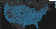
Your state's NTRIP Network is a series of "base stations" scattered throughout the state. Your RC Enterprise Controller connects to it by the Internet. I keep my phone in my pocket as a Internet Hotspot/Router to stay connected to the NTRIP internet network and it's data at all times.
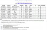
After you register with the state's NTRIP Network you will be given access to the Network's IP Address, Port Number and Mount Point Names. You just need to create a username and password after you have registered with the network.
Once you are connected to their network your drone will use their data to refine or correct it's own data and then label each mapping photo with highly accurate positioning data.

Your state's NTRIP Network is a series of "base stations" scattered throughout the state. Your RC Enterprise Controller connects to it by the Internet. I keep my phone in my pocket as a Internet Hotspot/Router to stay connected to the NTRIP internet network and it's data at all times.
After you register with the state's NTRIP Network you will be given access to the Network's IP Address, Port Number and Mount Point Names. You just need to create a username and password after you have registered with the network.
Once you are connected to their network your drone will use their data to refine or correct it's own data and then label each mapping photo with highly accurate positioning data.