DJI Mavic, Air and Mini Drones
Friendly, Helpful & Knowledgeable Community
Join Us Now

Military Rules vs FAA Rules

JimWest

Well-Known Member
Joined
Nov 23, 2019
Messages
241
Reactions
282
Age
77
Location
Detroit, Michigan USA
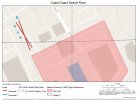
Looking for advice in flying near, but not over a military base. I'm a working photojournalist with a Part107 license. Every year before the lakes and river are choked with ice, the Coast Guard takes navigational buoys out of the water and stacks them up at their base on the Detroit River. The pile of buoys seemed like a fine subject for a stock photo. I stopped at the Coast Guard security shack to alert them that I'd be flying a drone—not over any part of the base, but nearby. I had a discussion with a guard who threatened to have me arrested. Said I could not photograph any part of the base from anywhere. I asked to talk to the Officer of the Day, who turned out to be a very nice young man who admitted that he hadn't run into this issue before. I told him I had no deadline,so he said he'd research it and get back to me. So, does anyone know what the actual rules for this situation are--the FAA says I can fly and the military says no. The area where I planned to fly (see the small blue x's on the attached map) is controlled airspace, and I had FAA approval for the flight. The plan was to fly straight up, remaining over the public walking path (dotted line). The buoys are located where the large red x is, with a fence and no trespassing sign between them and the walking path. The red area is of course the base, with closed airspace. Thanks for any thoughts on this.Coast Guard Detroit River.jpgairspace. Thanks for any help.
 
He's probably talking about NOTAM 1/5318. "NATIONAL SECURITY. See FDC 1/5318. Unmanned Aircraft (UA) operations are prohibited within 3,000 ft. laterally and 1,000 ft. above military vessels. Operating in the indicated airspace may result in disruption, seizure, or destruction of UA." Coast Guard vessels are also considered military vessels. So if they're underway, you can't fly within 3000' of them.

Also, every DOD Airspace Authorization I've seen (both of mine) says this, "Photographing and/or video recording military installations or equipment without obtaining permission from the installation commanding officer is prohibited by Federal Law."

So either way, I'd pass on gathering imagery of that area.
 
Looking for advice in flying near, but not over a military base. I'm a working photojournalist with a Part107 license. Every year before the lakes and river are choked with ice, the Coast Guard takes navigational buoys out of the water and stacks them up at their base on the Detroit River. The pile of buoys seemed like a fine subject for a stock photo. I stopped at the Coast Guard security shack to alert them that I'd be flying a drone—not over any part of the base, but nearby. I had a discussion with a guard who threatened to have me arrested. Said I could not photograph any part of the base from anywhere. I asked to talk to the Officer of the Day, who turned out to be a very nice young man who admitted that he hadn't run into this issue before. I told him I had no deadline,so he said he'd research it and get back to me. So, does anyone know what the actual rules for this situation are--the FAA says I can fly and the military says no. The area where I planned to fly (see the small blue x's on the attached map) is controlled airspace, and I had FAA approval for the flight. The plan was to fly straight up, remaining over the public walking path (dotted line). The buoys are located where the large red x is, with a fence and no trespassing sign between them and the walking path. The red area is of course the base, with closed airspace. Thanks for any thoughts on this.View attachment 171243airspace. Thanks for any help.
Follow Vic’s advice
 
He's probably talking about NOTAM 1/5318. "NATIONAL SECURITY. See FDC 1/5318. Unmanned Aircraft (UA) operations are prohibited within 3,000 ft. laterally and 1,000 ft. above military vessels. Operating in the indicated airspace may result in disruption, seizure, or destruction of UA." Coast Guard vessels are also considered military vessels. So if they're underway, you can't fly within 3000' of them.

Also, every DOD Airspace Authorization I've seen (both of mine) says this, "Photographing and/or video recording military installations or equipment without obtaining permission from the installation commanding officer is prohibited by Federal Law."

So either way, I'd pass on gathering imagery of that area.
Thanks, Vic. Your thoughts are always helpful. I had not known about the 3,000 foot boundary around operating vessels, which I have unknowingly violated several times while photographing icebreaking on the St. Mary's River. In this case, no vessels were operating and would not have been visible from where I planned to shoot. But too much trouble to pursue this, I think, even if I could end up getting permission.
 
Looking for advice in flying near, but not over a military base. I'm a working photojournalist with a Part107 license. Every year before the lakes and river are choked with ice, the Coast Guard takes navigational buoys out of the water and stacks them up at their base on the Detroit River. The pile of buoys seemed like a fine subject for a stock photo. I stopped at the Coast Guard security shack to alert them that I'd be flying a drone—not over any part of the base, but nearby. I had a discussion with a guard who threatened to have me arrested. Said I could not photograph any part of the base from anywhere. I asked to talk to the Officer of the Day, who turned out to be a very nice young man who admitted that he hadn't run into this issue before. I told him I had no deadline,so he said he'd research it and get back to me. So, does anyone know what the actual rules for this situation are--the FAA says I can fly and the military says no. The area where I planned to fly (see the small blue x's on the attached map) is controlled airspace, and I had FAA approval for the flight. The plan was to fly straight up, remaining over the public walking path (dotted line). The buoys are located where the large red x is, with a fence and no trespassing sign between them and the walking path. The red area is of course the base, with closed airspace. Thanks for any thoughts on this.View attachment 171243airspace. Thanks for any help.
I'm former USCG, it was a long time ago, and the mission has moved a bit from SAR and LE towards national security, but I bet the basic themes are still there. I would write an email or snail mail to the commanding officer of the CG station or base explaining what you want to photograph and why. Heck, with permission they might even invite you onto the station (possibly including a tour). You will get a reply, can't say what it will be, but mostly likely from a public affairs officer, either under the CO's name or the PA's name. Everything like this goes by the CO, at least in passing, don't worry about writing directly to the CO.
 
Thanks, Vic. Your thoughts are always helpful. I had not known about the 3,000 foot boundary around operating vessels, which I have unknowingly violated several times while photographing icebreaking on the St. Mary's River. In this case, no vessels were operating and would not have been visible from where I planned to shoot. But too much trouble to pursue this, I think, even if I could end up getting permission.
This is where flight rules stop making sense....
Anyone with a camera could easily stand on the bank of the river and shoot similar photos from the ground.
But it's prohibited from the air.
 
Last edited:
Update: The Physical Security Officer for the Coast Guard Detroit sector called me and said I'm welcome to use the drone as I wish, as long as I stay on public property and don't fly over the base. What a guy! He had a lot to say about the First Amendment and freedom of the press. I'm off to Denver to see the grandkids, so won't shoot until January, but we agreed that I'd check in with him when I'm back.
 
This is where flight rules stop making sense....
Anyone with a camera could easily stand on the bank of the river and shoot similar photos from the ground.
But it's prohibited from the air.
I actually think it does make some sense as long as its not carried to extremes. The drone could quickly be over a military vessel and do some damage, while someone with a camera on the shore half a mile away would have a more difficult time of it. But the rule makes more sense in the case of a nuclear submarine, for instance, and less in the case of a Coast Guard icebreaker or buoy tender.
 
  • Like
Reactions: CadrePilot
I actually think it does make some sense as long as its not carried to extremes. The drone could quickly be over a military vessel and do some damage, while someone with a camera on the shore half a mile away would have a more difficult time of it. But the rule makes more sense in the case of a nuclear submarine, for instance, and less in the case of a Coast Guard icebreaker or buoy tender.
Yeah, I think you're right. I didn't read it well before. My bad.
 
This is where flight rules stop making sense....
Anyone with a camera could easily stand on the bank of the river and shoot similar photos from the ground.
But it's prohibited from the air.
No really. My wife had to delete pictures from her camera under the watchful eye of the SP in San Diego.
 
This is where flight rules stop making sense....
Anyone with a camera could easily stand on the bank of the river and shoot similar photos from the ground.
But it's prohibited from the air.
In this case, they actually do make sense. You can see a lot more of an installation from the air than from the ground. At least they sort of make sense. It's a DOD thing.
 
Also, every DOD Airspace Authorization I've seen (both of mine) says this, "Photographing and/or video recording military installations or equipment without obtaining permission from the installation commanding officer is prohibited by Federal Law."
Vic, I have had the same problem that you experienced in DOD airspaces. I received an authorization for KNUW and it included this provision. Presumably the authority to issue this directive is derived from the following:

18 U.S.C. § 795 - Photographing and sketching defense installations

18 U.S.C. § 796 - Use of aircraft for photographing defense installations

18 U.S.C. § 797 - Publication and sale of photographs of defense installations

However, it's questionable whether any of these even apply at all if you are taking photographs from a publicly accessible area outside any military installation or the airspace thereof, given the great levels of protection offered by the First Amendment for journalistic activity.

The only recent case law that substantially relates to this topic is Toledo Blade v. United States of America, in which the federal government settled for $18,000 and attorney's fees after two journalists taking photographs were detained, put in handcuffs for several hours, and had their photographs destroyed by military police after taking photos from a publicly accessible area outside the Lima Army Tank Plant in Ohio.

Obviously they never want to let any of these cases go to trial because it would just show how blatantly unconstitutional and illegal these laws are.

I have already filed FOIA requests for various sets of documents related to my COA, but as anyone who has filed a FOIA or PRR knows, I don't know what, if anything, or when those documents will be provided.
 
  • Like
Reactions: Torque

DJI Drone Deals

New Threads

Members online

Forum statistics

Threads
131,130
Messages
1,560,129
Members
160,100
Latest member
PilotOne