Hi!
We are Theta Informatics LLC, creators of the free and open source OpenAthena software platform for iOS and Android.
We're excited to announce the launch of OpenAthena™ for iOS v2.0.
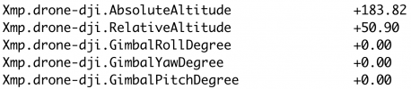
This app introduces exciting new capabilities to your drone, greatly enhancing its mission capabilities. The app allows you to calculate the precise ground location of any pixel which appears in images taken by your drone. Our software's custom processing engine extracts metadata present in drone images and uses it with a digital elevation model to calculate the precise location on Earth of any selected point in your images. Possible applications of this technology include search and rescue, agriculture, disaster response and public safety, environmental monitoring, and land management.
The app allows you to
(for the first time ever):
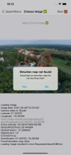
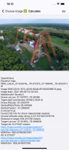
1. Load any image taken by your drone
2. Automatically download an elevation map
3. Tap anywhere in the image
4. Instantly obtain its precise ground location!

 +
+ 
 =
= 


.png")
The app does not report any details regarding your usage or other private information.
The app is free on the Apple App Store:
Our Android version is available on the Google Play, however automatic elevation model downloading will not be present until the next version:

 github.com
We're excited to hear about what you can do with it!
If you have any questions or feedback, please contact us at
[email protected]
Known incompatible drone models:
Theta Informatics LLC
We are Theta Informatics LLC, creators of the free and open source OpenAthena software platform for iOS and Android.
We're excited to announce the launch of OpenAthena™ for iOS v2.0.
This app introduces exciting new capabilities to your drone, greatly enhancing its mission capabilities. The app allows you to calculate the precise ground location of any pixel which appears in images taken by your drone. Our software's custom processing engine extracts metadata present in drone images and uses it with a digital elevation model to calculate the precise location on Earth of any selected point in your images. Possible applications of this technology include search and rescue, agriculture, disaster response and public safety, environmental monitoring, and land management.
The app allows you to
(for the first time ever):
1. Load any image taken by your drone
2. Automatically download an elevation map
3. Tap anywhere in the image
4. Instantly obtain its precise ground location!
+ = The app does not report any details regarding your usage or other private information.
The app is free on the Apple App Store:
OpenAthena
OpenAthena™ is a project which allows consumer and professional drones to spot precise locations through their images. This is accomplished by combining their sensor metadata with digital elevation data to provide the instant location of what is being observed.
apps.apple.com
Our Android version is available on the Google Play, however automatic elevation model downloading will not be present until the next version:
GitHub - Theta-Limited/OpenAthenaAndroid: OpenAthena allows common drones to spot precise geodetic locations
OpenAthena allows common drones to spot precise geodetic locations - Theta-Limited/OpenAthenaAndroid
github.com
We're excited to hear about what you can do with it!
If you have any questions or feedback, please contact us at
[email protected]
Known incompatible drone models:
- DJI Phantom 4 (not inc. Pro or Advanced versions, FC330 only)
- DJI Mini 2
- DJI Air 2 S (old firmware)
Theta Informatics LLC
Attachments
Last edited: