You are using an out of date browser. It may not display this or other websites correctly.
You should upgrade or use an alternative browser.
You should upgrade or use an alternative browser.
TNFZ
- Thread starter Lets Fly
- Start date
B52-D
Well-Known Member
My thoughts are that if a TFR was issued for the Presidents aircraft, you would not be able to fly either the Mavic Air or the M2Z while the TFR is active. ?
DJI responding to TFR is dependent on if the TFR was published far enough in advance for DJI to incorporate into the database.
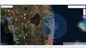
Just looked at geo map from Fly. The TFR is there for VIP. Two of them actually in concentric circles, active from 12/23 until 1/1. They are authorization zones so they can be unlocked. If you had unlocked, they won't show back up for hours to days.
I have marked my house approximately with the black arrow at the top of the TNFZ. It never covered my house in the past, and my Mavic air would not fly. Now on the map it shows it past my house and my M2Z will fly with no problem here. I have not pulled out the Mavic Air to see if it will fly now, also, the radius is supposed to be 30 miles and as I stated I live 32.5 from the airport center so I should be able to fly with no problem as I am now with the M2Z. The map has it well past that radius. I have never tried to unlock this zone. Just wondering about the accuracy of the DJI maps.

And yet I am.My thoughts are that if a TFR was issued for the Presidents aircraft, you would not be able to fly either the Mavic Air or the M2Z while the TFR is active. ?
60 miles and the map is past that.Presidential TFRs have a 50 mile diameter
dronerdave
Well-Known Member
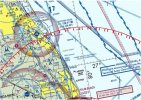
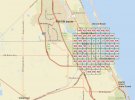
Here is what I see: Seems to be the same thing. As far as the AGL, I'm on the line of 200 to 400. If I fly towards Witham I stop like a wall is there. That AGL map is all the time for Stuart and nothing to do with the TNFZ.
View attachment 120206View attachment 120207
Those aren't showing the two concentric TFRs though.
dronerdave
Well-Known Member
I assume the first image is the TFR. The second is local airspace restrictions via GIS. However I don't know why one drone would fly while the other didn't except if the geofencing app is different between the two models. Could it depend on the latest updates?
The two concentric circles are definitely TFRs. If you click near the edge of the smaller one, it will show two nearly identical TFRs.
Closer in is the oddly shaped almost oval authorization zone for the airport.
Closer in is the oddly shaped almost oval authorization zone for the airport.
Marty Markoe
Well-Known Member
This is a case of FAKE NEWS perpetuated by a Deep State conspiracy. Or maybe not.
Off topic...is that a private airstrip to the left of Whitham called "Naked Lady"?
Heck of name for an airstrip.
Pilot to ground conversation, "I'm on final approach and ready to land on Naked Lady..."
MA2 317" data-source="post: 1169630" class="bbCodeBlock bbCodeBlock--expandable bbCodeBlock--quote js-expandWatch">Yes, Naked lady ranch has been there for a long time. Private airstrip and homes with their own hangersOff topic...is that a private airstrip to the left of Whitham called "Naked Lady"?
Heck of name for an airstrip.
Pilot to ground conversation, "I'm on final approach and ready to land on Naked Lady..."
like garages with driveways to the runway. Check it out on Google Map.
D
Deleted member 114292
Guest
It looks to me you’ve always been within the TFR. Weather DJI crazy town maps had you there or not is a different story.I have marked my house approximately with the black arrow at the top of the TNFZ. It never covered my house in the past, and my Mavic air would not fly. Now on the map it shows it past my house and my M2Z will fly with no problem here. I have not pulled out the Mavic Air to see if it will fly now, also, the radius is supposed to be 30 miles and as I stated I live 32.5 from the airport center so I should be able to fly with no problem as I am now with the M2Z. The map has it well past that radius. I have never tried to unlock this zone. Just wondering about the accuracy of the DJI maps.View attachment 120202
It looks like the DJI maps are not showing the SUA carve out. The Secret Service authorized the carve out as SUA is the southernmost airport north Of the TFR. The rich and famous of Palm Beach have to land their jets there when the TFR is in effect.
You should always check with sky vector as it is authoritative. Even if DJI lets you launch I would not fly in that TFR.
We have a community like that in West Pasco County.Yes, Naked lady ranch has been there for a long time. Private airstrip and homes with their own hangers
like garages with driveways to the runway. Check it out on Google Map.
I just tried to find the photo from last Christmas of the TNFZ when Trump came down and I must have deleted it. It did not cover my house at that time which is more than 30 miles from the airport, and again as I've said in the past not allowing a drone to fly thirty miles away is ridiculous to say the least, but it is what it is, and after January this will be over anyway.It looks to me you’ve always been within the TFR. Weather DJI crazy town maps had you there or not is a different story.
It looks like the DJI maps are not showing the SUA carve out. The Secret Service authorized the carve out as SUA is the southernmost airport north Of the TFR. The rich and famous of Palm Beach have to land their jets there when the TFR is in effect.
You should always check with sky vector as it is authoritative. Even if DJI lets you launch I would not fly in that TFR.
D
Deleted member 114292
Guest
The TFR has not changed so if you were not in it before you still are not.I just tried to find the photo from last Christmas of the TNFZ when Trump came down and I must have deleted it. It did not cover my house at that time which is more than 30 miles from the airport, and again as I've said in the past not allowing a drone to fly thirty miles away is ridiculous to say the least, but it is what it is, and after January this will be over anyway.
It was hard to tell from the map you posted of where your house is.
There is little rhyme or reason the the DJI zones.
And yes after Jan 20 the TFR will be gone.
Similar threads
- Replies
- 38
- Views
- 2K
- Replies
- 5
- Views
- 972
- Replies
- 4
- Views
- 524
DJI Drone Deals
1. Mini 2
2. Mini 3 Pro
3. Mini 4 Pro
4. Air 2s
5. Air 3
6. Avata 2
7. Mavic 3 Pro
8. Mavic 3 Classic
2. Mini 3 Pro
3. Mini 4 Pro
4. Air 2s
5. Air 3
6. Avata 2
7. Mavic 3 Pro
8. Mavic 3 Classic


