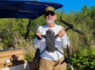
I'll admit straight away, I was flying too low and just lost visible but was feeling confident after a lovely flight along Taroona and Hinsby Beaches on Hobart's Derwent River (Tas.AU). One and a half minutes or so of gliding along, just off-shore, dolphins passing underneath, nice day, 3rd battery of the morning and at my range limit I turned for home, full forward stick and suddenly three beeps and a close glimpse of water on the screen then a dreadful blankness and red letters... "lost contact"!
The shock and knowing what's happened is like a car crash.. I started walking towards that end of the beach but stopped.. there was no point - somewhere 70-100 metres off the nearest shore and 500M from my position in 11 degree C water is my drowned drone. I went home with a long face, called DJI and started the process for an unrecovered accidental loss against my care refresh package - the support guy was great and said that I was covered for an unrecovered (pilot-error) flyaway but the cost would be A$850.
I rang a cousin who said "no worries.. I have a friend who owns a dingy on the next beach.. I'll call him". The following day he happily took me around to Hinsby Beach.. The DJI Fly "Find my drone" function put us near the spot but the resolution of the map made the "find" zone huge - it could have been 60 or more metres in any direction because there was no pinpointing where we were on that scale. On land: trees, roads, clearings and turning on "Beep and Flash" would have been enough but underwater and drowned.. Needle in the Haystack!
Still hoping, I dropped off the side of the dingy into the water with a 6mm thick, full body, semi-dry wetsuit, mask, fins and snorkel.. it was cold and visibility was awful. I thought I was prepared but it seemed I was floundering around trying to fix a point because because there's no markers on the water and everything underwater looks the same and it was murky with strange filaments like cobwebs that filled the water and reflected sunlight. I tried towing the dingy around to cast a shadow where it was easier to see. The haystacks just got bigger. I gave up after an hour or so and before the cold set in. Too many haystacks.
Back home again with another long face I called a friend to ask him if he had a nautical chart and told him I was thinking I could walk down the rocky shoreline to the same latitude, fix a line and swim out and snorkel around a search area.. he was keen and the next day we found a way down a gully to a launch spot and then planned to come back with all the gear.
One week after the crash we came back to the gully with our wetsuits, fins, masks, snorkels, weight belts and a buoy with a shot line and high hopes but it was a steep and tricky clamber down to a rougher launch place than we would have liked. During the week I had also found an app that constantly reads out Lat/Long and I planned to swim to the last known co-ords by watching the screen then dropping the shot line to mark the start of the search..
Sadly, out from the rocky launch it was just more floundering around in freezing water with the phone in a zip-lock bag and water splashing on the screen causing it to change, and then me not being able to read it properly when it was on the correct app. Eventually, I thought I was on the right place, dropped the marker and started searching up and down. After more than an hour in the cold water without any sign I knew I had to get out.. I was freezing, loosing buoyancy and knew it was dumb to get into peril for a lost drone.. Inside, something said "stop now" - nothing a good credit card can't fix.
Home again.. I'll just pay the Fly-Away replacement cost.
...but. I want to try again. one more time. properly prepared!
I upgraded the App for A$12.99 and it now shows in metres the distance and relative bearing to your set location plus an accuracy factor.. I also bought a waterproof accessory bag to put the phone in. I tried the app in the car park at work and it looks pretty impressive.
I call my friend again who has has two sit-on-top kayaks and he's happy to come out and we agree this time he's not getting in the water and will look after the boats when I drop in. He'll also bring the shot line and buoy and a weight belt for me.
Full of hope, I dial in the co ords from the log file into the app..
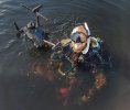
We paddle out from the beach - we're 600M from the last known position, we're dry and warm and after 500M paddling I turn the phone on and start the app.. 8 or 9 passes back and forth with the app showing a few metres from "last Known" we place the buoy.. I paddle away and refine the position - 6M NW of the first placement. I do it again. another few metres north. I try lying on the boat with my face in the water but its difficult and uncomfortable. My friend takes the bowline of my kayak and I slide into the cold wetness. Again, the weed and rock and bottom looks vast as I snorkel around. 10 minutes later I think that I have to trust the buoy placement and localise the search close to there. The weed is swaying back and forth, there's rocky lumps and hollows, a fish, more weed, another hollow and suddenly, there it is.. less than 3M from the weight attached to the shot line.
I was planning to take a photo of the drone on the bottom with my Olympus TG-6 and get the video recording it as I dive down.
Forget it, just be thankful. Drone Found!
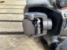
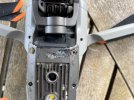
Back home - close inspection shows its in awful condition. Everything that moves is full of sandy grit but worse than that the alu-metal shell of the camera and heatsink underbelly has eroded or corroded away or blowing apart from the plastic casing.. I removed the battery which is swollen and leaking and now sits outside the house isolated on a concrete slab. Ferris screws are rusting quickly. Its a sad sight. The Micro SD was readable and I recovered all images after rinsing and wiping with isopro.
My name and number sticker was still intact.
Loved flying my A2S. Glad to have salvaged the wreckage to send back to the maker.
Several lessons rammed home.
Blue skies,
Chris
The shock and knowing what's happened is like a car crash.. I started walking towards that end of the beach but stopped.. there was no point - somewhere 70-100 metres off the nearest shore and 500M from my position in 11 degree C water is my drowned drone. I went home with a long face, called DJI and started the process for an unrecovered accidental loss against my care refresh package - the support guy was great and said that I was covered for an unrecovered (pilot-error) flyaway but the cost would be A$850.
I rang a cousin who said "no worries.. I have a friend who owns a dingy on the next beach.. I'll call him". The following day he happily took me around to Hinsby Beach.. The DJI Fly "Find my drone" function put us near the spot but the resolution of the map made the "find" zone huge - it could have been 60 or more metres in any direction because there was no pinpointing where we were on that scale. On land: trees, roads, clearings and turning on "Beep and Flash" would have been enough but underwater and drowned.. Needle in the Haystack!
Still hoping, I dropped off the side of the dingy into the water with a 6mm thick, full body, semi-dry wetsuit, mask, fins and snorkel.. it was cold and visibility was awful. I thought I was prepared but it seemed I was floundering around trying to fix a point because because there's no markers on the water and everything underwater looks the same and it was murky with strange filaments like cobwebs that filled the water and reflected sunlight. I tried towing the dingy around to cast a shadow where it was easier to see. The haystacks just got bigger. I gave up after an hour or so and before the cold set in. Too many haystacks.
Back home again with another long face I called a friend to ask him if he had a nautical chart and told him I was thinking I could walk down the rocky shoreline to the same latitude, fix a line and swim out and snorkel around a search area.. he was keen and the next day we found a way down a gully to a launch spot and then planned to come back with all the gear.
One week after the crash we came back to the gully with our wetsuits, fins, masks, snorkels, weight belts and a buoy with a shot line and high hopes but it was a steep and tricky clamber down to a rougher launch place than we would have liked. During the week I had also found an app that constantly reads out Lat/Long and I planned to swim to the last known co-ords by watching the screen then dropping the shot line to mark the start of the search..
Sadly, out from the rocky launch it was just more floundering around in freezing water with the phone in a zip-lock bag and water splashing on the screen causing it to change, and then me not being able to read it properly when it was on the correct app. Eventually, I thought I was on the right place, dropped the marker and started searching up and down. After more than an hour in the cold water without any sign I knew I had to get out.. I was freezing, loosing buoyancy and knew it was dumb to get into peril for a lost drone.. Inside, something said "stop now" - nothing a good credit card can't fix.
Home again.. I'll just pay the Fly-Away replacement cost.
...but. I want to try again. one more time. properly prepared!
I upgraded the App for A$12.99 and it now shows in metres the distance and relative bearing to your set location plus an accuracy factor.. I also bought a waterproof accessory bag to put the phone in. I tried the app in the car park at work and it looks pretty impressive.
I call my friend again who has has two sit-on-top kayaks and he's happy to come out and we agree this time he's not getting in the water and will look after the boats when I drop in. He'll also bring the shot line and buoy and a weight belt for me.
Full of hope, I dial in the co ords from the log file into the app..
We paddle out from the beach - we're 600M from the last known position, we're dry and warm and after 500M paddling I turn the phone on and start the app.. 8 or 9 passes back and forth with the app showing a few metres from "last Known" we place the buoy.. I paddle away and refine the position - 6M NW of the first placement. I do it again. another few metres north. I try lying on the boat with my face in the water but its difficult and uncomfortable. My friend takes the bowline of my kayak and I slide into the cold wetness. Again, the weed and rock and bottom looks vast as I snorkel around. 10 minutes later I think that I have to trust the buoy placement and localise the search close to there. The weed is swaying back and forth, there's rocky lumps and hollows, a fish, more weed, another hollow and suddenly, there it is.. less than 3M from the weight attached to the shot line.
I was planning to take a photo of the drone on the bottom with my Olympus TG-6 and get the video recording it as I dive down.
Forget it, just be thankful. Drone Found!
Back home - close inspection shows its in awful condition. Everything that moves is full of sandy grit but worse than that the alu-metal shell of the camera and heatsink underbelly has eroded or corroded away or blowing apart from the plastic casing.. I removed the battery which is swollen and leaking and now sits outside the house isolated on a concrete slab. Ferris screws are rusting quickly. Its a sad sight. The Micro SD was readable and I recovered all images after rinsing and wiping with isopro.
My name and number sticker was still intact.
Loved flying my A2S. Glad to have salvaged the wreckage to send back to the maker.
Several lessons rammed home.
Blue skies,
Chris