ben.boozer's latest activity
-
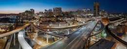
Bben.boozer replied to the thread Air 3s Night panorama with Air 3s.Appreciate all the comments. I believe the trail is called the Floodwall trail and is mixed use. There is a spot where you can launch and fly directly up between multiple elevated roads and railways. No need to even use the right stick. For this...
-
Bben.boozer replied to the thread Air 3s Night panorama with Air 3s.Nice! Thanks for the tips too.
-
BWent out to one of my favorite hikes where I can send the drone straight up between two roads and a railway track to take this pano from a crop of 24 images using the 3x camera. Image size around 18k x 6.9k pixels. I wanted to see what the Adobe...
-
-
Bben.boozer replied to the thread Need a better video editor.Davinci Resolve Training - click the link for more than you need to know. Ben
-
Bben.boozer replied to the thread AUTOPANO GIGA as 'free-ware'.Thank you! Now, anyone happen to have a pdf manual for version 4 that they might be persuaded to share?