DJ Wes's latest activity
-
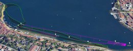
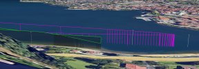
 DJ Wes replied to the thread Waypoint Mission (IMPOSSIBLE) !!!!! 🇦🇮🦘.I prefer to have missions that will bring the drone back to me without any manual input from me. Here is how I would adjust your mission: When using DJI Fly, it would look like this (red path): Keep all of the waypoint heights the same...
 -
-
I tried out some new light paintings last night and the Northern Lights decided to join me. The first two are the light paintings. One is tracked with a star tracker and one is not. The last one is taken from my Mavic 3 Pro with settings F2.8 ISO...
-
DJ Wes replied to the thread CSV files not accepted by Airdata.One of my utilities will convert a flight log (from AirData) into a Litchi waypoint mission. In order to do that, you must first have your flight logs synced to the AirData web site. Once in AirData, you can download a log file in CSV format...
-
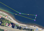
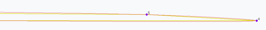
DJ Wes replied to the thread Waypoint Mission (IMPOSSIBLE) !!!!! 🇦🇮🦘.I have analyzed your mission and your flight path. Your mission lies primarily along a very long, straight line. Waypoint 4 creates a sharp turning point where the drone changes direction 180 degrees. Up until waypoint 4 the drone was...
-
-
DJ Wes replied to the thread Waypoint Mission (IMPOSSIBLE) !!!!! 🇦🇮🦘.I can see that the drone went from 64ft down to 22ft when you exited waypoint mode. If you would like me to analyze the mission, I would need to see the waypoints. Are you able to access and provide the mission? These instructions will show...