DJ Wes's latest activity
-
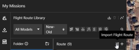
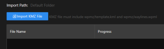
 DJ Wes replied to the thread M3T - Pilot 2 for wind blades images with Waypoints.I am not familiar with Pilot 2 and its requirements. All of my testing has been done in DJI Flight Hub 2: And the import function: Don't confuse a DJI KMZ file with a Google Earth KMZ file. While they are both compressed archives, they...
 -
-
DJ Wes replied to the thread M3T - Pilot 2 for wind blades images with Waypoints.I have a Litchi mission planner for wind turbine inspections. It can be used to create a flight path along each blade based on the geometry of the wind turbine. The resulting Litchi mission CSV file can be converted to a DJI KMZ file for the...
-
DJ Wes reacted to mavic3usa's post in the thread Help interpret latitude/longitude coordinates of DJI hyperlapse data with
 Like.
Google in AI mode: what kinds of gps coordinates are these: convert radians "longitude": -1.3876699869292957,"latitude": 0.7782552034686965, to gps dms or what kinds of gps coordinates are these: "longitude": -1.3876699869292957,"latitude"...
Like.
Google in AI mode: what kinds of gps coordinates are these: convert radians "longitude": -1.3876699869292957,"latitude": 0.7782552034686965, to gps dms or what kinds of gps coordinates are these: "longitude": -1.3876699869292957,"latitude"... -
DJ Wes replied to the thread Help interpret latitude/longitude coordinates of DJI hyperlapse data.I'm replying to my own post. I figured out how to interpret those coordinates. DJI is storing the coordinates in radians, not degrees.
-
DJ Wes posted the thread Help interpret latitude/longitude coordinates of DJI hyperlapse data in Control Apps - DJI, Litchi, Autopilot, etc....I have been provided a DJI hyperlapse JSON file and the corresponding DJI flight log file. I am trying to interpret the longitude and latitude values stored in the JSON file. For each waypoint in the hyperlapse JSON file there is this data...