wco81's latest activity
-
Wwco81 replied to the thread Drone Flying in Norway - A Pilot Report.Did you take off after climbing up towards the top? I've heard it takes several hours to do so. Or can you take off from closer to the bottom of the fjord and have the drone ascend?
-
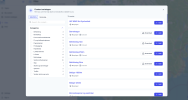
Wwco81 replied to the thread Drone Flying in Norway - A Pilot Report.Which filters did you apply to the www.safetofly.no maps? Because I just see a map, no zones of any kind to indicate which areas are okay and which ones aren't for drones. Then I see on the left column catalogue and I get this window to select...
-
-
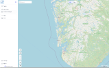
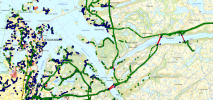
Wwco81 replied to the thread Air 3 Western Norway is the best part of Norway!.I looked for drone maps. Looks like you have to consult one for airports, for national security and for some agency which controls the national parks and nature preserve areas. And many of this information is only in Norwegian. They...
-
-
Wwco81 replied to the thread Mini 5 Pro officially launched outside the US..How does a Korean seller collect tax? Are they going to send the taxes to some agency for every state?
-
Wwco81 replied to the thread Owning a Canadian Mini 5 Pro in the US.Because when you enter Canada with a drone and tell them you plan to fly it, they issue that document as a record of you bringing in a drone? Does US Customs look for that document when you return from Canada?