Looking for some input from fellow mavic pilots on creating 3D maps of golf courses. I have a number of options to create the mission, collect the images, but not sure what's next. I'm aware of dronedeploy, pix4D, maps made easy, etc. but have questions about the the specific requirements to get 3D models. Any input on workflow, and ideally, some sample images, would be much appreciated.
You are using an out of date browser. It may not display this or other websites correctly.
You should upgrade or use an alternative browser.
You should upgrade or use an alternative browser.
3D Mapping Workflow
- Thread starter Timotheous
- Start date
Welcome to the forum from the land of Oz. I’m currently doing a short course on Udemy on 3D modelling, pretty interesting stuff. Hope someone’s comes up with the response you need.
Regards
Regards
Thanks good to be here. Lots if interesting stuff on this forum; should be able to learn a lot. Been flying drones for years, but only recently getting opportunities to do some 3D mapping. Hope to get some advice in that regard.Welcome to the forum from the land of Oz. I’m currently doing a short course on Udemy on 3D modelling, pretty interesting stuff. Hope someone’s comes up with the response you need.
Regards
Timotheous, have you thought about putting this request on the sister forum Commercial Pilots.
Regards
Regards
Good idea, I will give that a shot. Thanks.Timotheous, have you thought about putting this request on the sister forum Commercial Pilots.
Regards
Was able to resolve the workflow questions. It's actually quite easy. I used "maps made easy" and simply followed the instructions - fly the route, upload the images, wait for processing. It took a few hours for processing but I received a 3D map, an Orthomosaic map (shows elevations) and a well-rendered RGB map. It wasn't clear from the documentation anywhere, but getting the 3D map was a default output from "maps made easy". For reference, I used DJI Pilot PE to collect the mapping images. Drone was Mavic 2 Pro with smart controller (yes, you can install DJI Pilot PE on smart controller - see "multicoperwarehouse" youtube video for instructions).
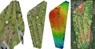
Here are some samples of the output from my recent mapping tests. I focused on holes 1 and 2 of a local golf course. From left to right: 3D image, RGB map, Elevation Map, and finally, Plant Health map. For the first three, I used maps made easy. For the last one, I used DroneDeploy. I was able to obtain the Plant Health map using the standard RGB camera with a VARI filter applied within the DroneDeploy app. Happy to answer any questions fellow pilots may have.


guyrws
New Member
- Joined
- Apr 5, 2019
- Messages
- 3
- Reactions
- 2
- Age
- 72
- Location
- Buckinghamshire UK
- Site
- thisisthewayup.co.uk
Hi Timotheous,Was able to resolve the workflow questions. It's actually quite easy. I used "maps made easy" and simply followed the instructions - fly the route, upload the images, wait for processing. It took a few hours for processing but I received a 3D map, an Orthomosaic map (shows elevations) and a well-rendered RGB map. It wasn't clear from the documentation anywhere, but getting the 3D map was a default output from "maps made easy". For reference, I used DJI Pilot PE to collect the mapping images. Drone was Mavic 2 Pro with smart controller (yes, you can install DJI Pilot PE on smart controller - see "multicoperwarehouse" youtube video for instructions).
Your workflow will fit almost exactly around my hardware.
I have already installed PilotPE onto my SmartConroller, processed some images using MapsMadeEasy (that I collected when I trialed DroneDeploy) but have not been able to solve the desktop planning problem.
Can you tell me if are you doing your flight planning directly via the PilotPE app on the SmartController or have you found a desktop planning workaround please?
Cheers, Guy.
Jagerbomb52
Well-Known Member
Five or 6 years ago I played around with the demo version of Agisoft Metashape Professional. Found it to be a very easy work flow but at the time very hard for my old computer to use. This was actually done using a old Yuneec Q500 taking what I thought was the right amount of photos to render this 3D model of the waterfalls up the road from me in the winter when it was frozen. Thought it came out pretty good for a first go at it.
Not sure if they still offer the demo but it is a interesting piece of software.
Agisoft workflow
Not sure if they still offer the demo but it is a interesting piece of software.
Agisoft workflow
Last edited:
bushie
Well-Known Member
Many years ago I worked as an engineering surveyor on a dam construction job. On the last day of the month we did a stadia (remember that) survey of the quarry, borrow pits and stock piles to measure the quantity of work done during the month to make progress payments. Took a week to draw the contours, measure them with a planometer and calculate the quantities.
How technology has changed.
How technology has changed.
Hey Guy,Hi Timotheous,
Your workflow will fit almost exactly around my hardware.
I have already installed PilotPE onto my SmartConroller, processed some images using MapsMadeEasy (that I collected when I trialed DroneDeploy) but have not been able to solve the desktop planning problem.
Can you tell me if are you doing your flight planning directly via the PilotPE app on the SmartController or have you found a desktop planning workaround please?
Cheers, Guy.
I'm actually doing the mapping directly on the smart controller. I did however, buy a standard mavic 2 controller in case I want to go back to using a tablet/phone. So far though, I have managed to do the mapping within Pilot - using reading glasses and a rubber-ended stylus! A bit of a hassle, but it's working well for me. Also using the same setup on an Matrice 300. With that smart controller, you have the option of adding a tablet (must be android though).
dap455
Well-Known Member
I have been using Webodm for creating 3D modeling, Orthomosaics and DSM's.
Webodm is totally free and the output rivals pretty much anything out there. You do not have all the bells and whistles you would get with products like DroneDeploy but is is a great tool to learn the process and get a good understanding for creating different types of maps. I use Copterus for mapping and Webodm for creating Orthomosaics and 3D models, then use apps like QGIS and Meshlab to create the final output.
Webodm is totally free and the output rivals pretty much anything out there. You do not have all the bells and whistles you would get with products like DroneDeploy but is is a great tool to learn the process and get a good understanding for creating different types of maps. I use Copterus for mapping and Webodm for creating Orthomosaics and 3D models, then use apps like QGIS and Meshlab to create the final output.
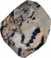
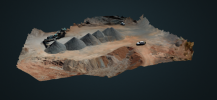
Wondering whether you have any more samples to share. Thanks!I do it as part of my job. I do the volume estimates before we bring in the proper surveyors. this one wasn't much chop, to many shadows throw out your volumetric calculations. I just did this one this afternoon in 3d.
View attachment 129325
Similar threads
- Replies
- 6
- Views
- 2K
- Replies
- 4
- Views
- 731
- Replies
- 2
- Views
- 755
- Replies
- 3
- Views
- 1K
DJI Drone Deals
Members online
Total: 2,297 (members: 11, guests: 2,286)


