

Drone mapping, photogrammetry aid recovery in wake of Helene devastation
By DRONELIFE Features Editor Jim Magill
(Part of a series on the drone community’s response to natural disasters)
Hurricane Helene, the massive and deadly storm that tore through a large swath of the U.S. Southeast in late September, triggered a tremendous response from the drone-flying community, as individual operators and private companies deployed their UAVs to transport much needed supplies and medicines, assess the damage wrought by flooded streams and rivers and even help locate the remains of people who tragically perished in the devastating floods.
NCDOTcommunications, CC BY 2.0
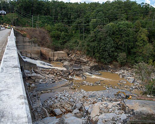
Despite all predictions to the contrary, western North Carolina was especially hard-hit by Hurricane Helene, whichafter making landfall as a Category 4 hurricane in the Big Bend region of Florida on September 27 tore a path of destruction through Georgia and roared through the southern Appalachian Mountain region as a tropical storm, dumping record-breaking amounts of rainfall across the region.
The historic rainfall caused massive flooding as several rivers and creeks in the region overflowed and inundated a number of communities. Mudslides and landslides destroyed highway infrastructure, leaving many areas cut off from power, transportation and communications. The storm and its aftereffects resulted in an estimated 96 deaths in North Carolina, and Gov. Roy Cooper’s administration estimated the damages would total at least $53 billion.
Aaron Schradin, the cofounder and CEO of software company Virtual Sandtable, said the flooding presented unique challenges to local disaster responders. The company volunteered its services to provide drone-based mapping and photogrammetry services to aid emergency workers in the area around Spruce Pines, N.C., in the wake of the storm
[Cotinue Reading}
By DRONELIFE Features Editor Jim Magill
(Part of a series on the drone community’s response to natural disasters)
Hurricane Helene, the massive and deadly storm that tore through a large swath of the U.S. Southeast in late September, triggered a tremendous response from the drone-flying community, as individual operators and private companies deployed their UAVs to transport much needed supplies and medicines, assess the damage wrought by flooded streams and rivers and even help locate the remains of people who tragically perished in the devastating floods.
Drones Aid Disaster Recovery: Mapping and Photogrammetry Support Hurricane Helene Relief Efforts
October 27, 2024 by Miriam McNabb Leave a CommentDrone mapping, photogrammetry aid recovery in wake of Helene devastation
By DRONELIFE Features Editor Jim Magill(Part of a series on the drone community’s response to natural disasters)
Hurricane Helene, the massive and deadly storm that tore through a large swath of the U.S. Southeast in late September, triggered a tremendous response from the drone-flying community, as individual operators and private companies deployed their UAVs to transport much needed supplies and medicines, assess the damage wrought by flooded streams and rivers and even help locate the remains of people who tragically perished in the devastating floods.
Drones come to the rescue after flooding in North Carolina
NCDOTcommunications, CC BY 2.0
Despite all predictions to the contrary, western North Carolina was especially hard-hit by Hurricane Helene, whichafter making landfall as a Category 4 hurricane in the Big Bend region of Florida on September 27 tore a path of destruction through Georgia and roared through the southern Appalachian Mountain region as a tropical storm, dumping record-breaking amounts of rainfall across the region.
The historic rainfall caused massive flooding as several rivers and creeks in the region overflowed and inundated a number of communities. Mudslides and landslides destroyed highway infrastructure, leaving many areas cut off from power, transportation and communications. The storm and its aftereffects resulted in an estimated 96 deaths in North Carolina, and Gov. Roy Cooper’s administration estimated the damages would total at least $53 billion.
Aaron Schradin, the cofounder and CEO of software company Virtual Sandtable, said the flooding presented unique challenges to local disaster responders. The company volunteered its services to provide drone-based mapping and photogrammetry services to aid emergency workers in the area around Spruce Pines, N.C., in the wake of the storm
[Cotinue Reading}
Last edited:


