You are using an out of date browser. It may not display this or other websites correctly.
You should upgrade or use an alternative browser.
You should upgrade or use an alternative browser.
Dronecast or UAV Forecast?
- Thread starter Paul Iddon
- Start date
Yogi053
Well-Known Member
I have UAV Forecast installed to give me a general idea but use common sense and my own judgement before flying.
@Paul Iddon when it comes to these sorts of apps ,then trust is not a word that i would use personally, to describe their accuracy ,they are a generalisation of possible conditions where you are,its much better to go to the place you want to fly and gauge the conditions for yourself
look at surrounding cloud types, their speed of movement across the sky, direction ,any signs of precipitation heading your way
then look at the tall trees around you are they battling the wind or nice and calm
dont forget that generally wind speed increases with altitude ,and the topography of the area you are at can have an affect on the wind, such as direction changes at differing altitudes ,and one big thing to always remember is ,if you are in any doubt about being able to complete the flight, and get your drone home safely then dont fly at that moment ,weather conditions can change very quickly
GregS
Well-Known Member
I have the UAV app and only use it to see what the winds aloft are. 99% of the time, I just look out the window.
Macinfo
Well-Known Member
I use UAV Forecast, and either app. if providing reasonable info on current conditions can give you some idea whether you might want to fly, however as noted a few times, your own observations are best.
I've noted that sometimes even if it says ok to fly, that it's not that great, too windy perhaps. While Drones do have temp limitations, in some cases its the pilot that suffers if its too hot or too cold to be comfortable and safe to fly.
I've noted that sometimes even if it says ok to fly, that it's not that great, too windy perhaps. While Drones do have temp limitations, in some cases its the pilot that suffers if its too hot or too cold to be comfortable and safe to fly.
retiredNH
Well-Known Member
Note that UAVforecast has settings that will affect its cautions. I use it as a guide, but, as others have said, what I see and feel outside is more important.
REStewart
Well-Known Member
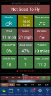
One example of these apps being useful would be if you are flying a paid mission that has a requirement for some allowable amount of cloudiness. Real estate jobs are a good example. For example if the job spec says "Up to 50% cloudy" and app says 47% cloudy (like the shot above) then I take a screen shot and proceed with the mission. If there's a question after capturing the photos/video then you have a basis for your decision to proceed (and get paid).
Thank you all for your considered replies.
Prevailing conditions while I am outside do determine (if I fly) my thoughts.
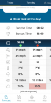
I showed a screenshot of both apps moments apart and one suggested no, the other yes, as to whether the elements were favourable. As guides they left a question, but looking outside suggested the former was in these instances, the better prediction.
Personal choices will outweigh an app then, but it did interest me whether one was more reliable than the other.
Once more, thanks for the valuable input everyone
Paul.
Prevailing conditions while I am outside do determine (if I fly) my thoughts.
I showed a screenshot of both apps moments apart and one suggested no, the other yes, as to whether the elements were favourable. As guides they left a question, but looking outside suggested the former was in these instances, the better prediction.
Personal choices will outweigh an app then, but it did interest me whether one was more reliable than the other.
Once more, thanks for the valuable input everyone

Paul.
make sure both your apps have the same settings like wind speeds that you are able to fly in
Rchawks
Well-Known Member
I would also add that reading wind velocity using the motion of trees in the wintertime is much more difficult than in the summer or anytime with leaves on the trees. I also use the UAV app and as stated this is a forecast and not real time although most of the time it's not bad for a second opinion or insight. It also gives you an educated guess as to what your wind velocity might be at your max altitude limit of 400 ft to help you make that judgement on whether to fly or not. It's also not just about being able to safely fly at the maximum height, but being able to take off and land in windy conditions as well. Even with GPS your drone uses it can be kicked around quite a bit during takeoff and landing. Someone here provided a METRA TAF which I use for from the local airport which the pilots luse at the airport nearby.
Similar threads
- Replies
- 18
- Views
- 5K
- Replies
- 16
- Views
- 1K
- Replies
- 11
- Views
- 2K
- Replies
- 10
- Views
- 2K
- Replies
- 22
- Views
- 8K
DJI Drone Deals
New Threads
-
-
-
-
DJI Mavic 2 Enterprise Thermal Dual plus DJI RC Pro - New
- Started by Merlin04
- Replies: 0


