DJI Mavic, Air and Mini Drones
Friendly, Helpful & Knowledgeable Community
Join Us Now

Geolocation information of a drone photo

RonanCork

Well-Known Member
Joined
Jan 22, 2019
Messages
324
Reactions
249
Age
46
Location
Cork. Ireland
Hi Guys,

Hope you're all well.

I've an Air2s and a client has reached out to me asking me to capture some aerial photography for them - standard stuff no problems.

He said:
  1. The images will be used to generate photomontages showing a proposed extension to an existing industrial development.
  2. Are you able to provide the data showing the geolocation of the captured photography as we would need this when inputting our model to the captured photography?
Any of you guys had experience of doing this geolocation part before ?

I know you can get the GPS coordinates of the photo and I've seen before them in Lightroom I'm guessing this is what he means. I can ask him but just wanted to be sure I wasn't asking something daft i should know

Any thoughts / guidance would be great

Thanks Ro
 
Last edited:
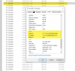
ah I think I've answered my own question. If I right click on the DNG/RAW file in Windows File Explorer and choose Properties > Details, I can then see the information. I'll double check with the client that this is what there referring too.

The above is fine for 1 or 2 photos but if I take 30 or 40 photos for example - is there some way I can "extract" the GPS data in 1 go (using a tool or viewing some meta data file ?

1684517234084.png
 
  • Like
Reactions: AnDronioBanderos
The above is fine for 1 or 2 photos but if I take 30 or 40 photos for example - is there some way I can "extract" the GPS data in 1 go (using a tool or viewing some meta data file ?
Just search online for EXIF extraction tool. Find the right one for the OS that you are using. Something like ExifTool should do what you need.
 
...Are you able to provide the data showing the geolocation of the captured photography as we would need this when inputting our model to the captured photography?
The position you find in the exif is from where you took the picture (the drone position)... it's not the objects position. This might not matter for your client, but just so you know.
 
The position you find in the exif is from where you took the picture (the drone position)... it's not the objects position. This might not matter for your client, but just so you know.
Very good point. Thanks for that.
 
ah I think I've answered my own question. If I right click on the DNG/RAW file in Windows File Explorer and choose Properties > Details, I can then see the information.
Just be aware that the altitude data you see this way is likely to be very inaccurate.
There are two different altitude numbers recorded in the image metadata.
One is relative height.
That's the one you see on your screen when flying.
The other is Absolute Altitude and it can be out by +/-2-300 feet.
Unfortunately that's the one Windows shows you.
You need a proper metadata viewer to see both altitude numbers.
 
  • Like
Reactions: mavictk and SethB
Just be aware that the altitude data you see this way is likely to be very inaccurate.
There are two different altitude numbers recorded in the image metadata.
One is relative height.
That's the one you see on your screen when flying.
The other is Absolute Altitude and it can be out by +/-2-300 feet.
Unfortunately that's the one Windows shows you.
You need a proper metadata viewer to see both altitude numbers.
Hi thanks for the details. Very much appreciated. So a proper viewer something like "EXIF data viewer" etc ? Cheers
 
Hi thanks for the details. Very much appreciated. So a proper viewer something like "EXIF data viewer" etc ? Cheers
I don't know that one (there are plenty of exif viewers).
As long as it shows the XMP section of the metadata, it will have both altitudes like this :
i-86h32VK-L.jpg

Heights are in metres.
Can you guess which one is incorrect?
 
I once had to locate the exact position of encampment fires on 39 acres of land. A picture of each spotted cAmp from a distance was needed to establish terrain context. I then hovered at 100 ft directly above the fire ring with the camera looking directly down and took that picture for the exact geolocation. It worked and the clean up crew located every camp. Many of these were hidden from viewing from surrounding roads and yards. Two pictures per camp!
 
  1. The images will be used to generate photomontages showing a proposed extension to an existing industrial development.
  2. Are you able to provide the data showing the geolocation of the captured photography as we would need this when inputting our model to the captured photography?
Any of you guys had experience of doing this geolocation part before ?
I find it more efficient to use a script to extract and or remove EXIF data depending on the requirement(s).
Especially when lots of images are involved. Output from a script is easier to copy out than most GUI based tools.
Much depends on your Operating System, of course. I don't recall you mentioning that in the thread.
Here is the output from one of my scripts:
Code:
Which data would you like to display? (1) All EXIF Data, (2) GPS Data: 2
GPSVersionID                    : 2.3.0.0
GPSLatitudeRef                  : North
GPSLatitude                     : 44 deg 18' 56.41"
GPSLongitudeRef                 : West
GPSLongitude                    : 124 deg 6' 8.13"
GPSAltitudeRef                  : Above Sea Level
GPSAltitude                     : 66 m
GPSLatitude                     : 44 deg 18' 56.41" N
GPSLongitude                    : 124 deg 6' 8.13" W
GPSAltitude                     : 66 m Above Sea Level
GPSLatitude                     : 44 deg 18' 56.41" N
GPSLongitude                    : 124 deg 6' 8.13" W
GPSPosition                     : 44 deg 18' 56.41" N, 124 deg 6' 8.13" W
 
Last edited:
I find it more efficient to use a script to extract and or remove EXIF data depending on the requirement(s).
Especially when lots of images are involved. Output from a script is easier to copy out than most GUI based tools.
Much depends on your Operating System, of course. I don't recall you mentioning that in the thread.
Hi thanks for the reply. Forgot to mention I'm on Windows 10.
Ro
 
Here is the output from one of my scripts:

GPSAltitudeRef : Above Sea Level
GPSAltitude : 66 m
That field labelled GPS Altitude, is the Absolute Altitude.
It's not actually from GPS and it's the one that can be out by +/- hundreds of feet.
 
  • Wow
Reactions: @Rip
Well it seems pretty clear after reading dozens of threads here, DJI's website, Garmin, etc. that one must not make unsupported assumptions when it comes to GPSAltitude. Thanks to Meta4 for motivating me to look deeper into this issue. When a client asks me for altitude data it will come with a disclaimer, at least.
 
Last edited:
Well it seems pretty clear after reading dozens of threads here, DJI's website, Garmin, etc. that one must not make unsupported assumptions when it comes to GPSAltitude. Thanks to Meta4 for motivating me to look deeper into this issue. When a client asks me for altitude data it will come with a disclaimer, at least.
The Relative Altitude which is found in the XMP section of teh image metadata is accurate (relative to the launch point) to about +/- 10 feet.
It's just the Absolute Altitude that is problematic.

What DJI label as GPS Altitude isn't from GPS.
It's derived from a flawed algorithm that calculates altitude from air pressure.
The problem with the formula is that they assumed standard atmospheric pressure and didn't allow for daily fluctuations.
You can confirm that by checking tit for images taken at the same place and height at different times, with different weather.
Like this pair:
i-wMWSXK7-X3.jpg
 
Last edited:
Yeah! Absolutely! I get it now! Thanks @Meta4 ... I have already altered my script to include relative altitude based on your comments going back as far as 2016 ? I think. I suppose you are getting tired of answering the same queries all the time? Yes?
Code:
Which data would you like to display? (1) All EXIF Data, (2) GPS and RelativeAltitude Data: 2
GPSLatitudeRef                  : North
GPSLatitude                     : 44 deg 18' 56.41"
GPSLongitudeRef                 : West
GPSLongitude                    : 124 deg 6' 8.13"
GPSAltitudeRef                  : Above Sea Level
GPSLatitude                     : 44 deg 18' 56.41" N
GPSLongitude                    : 124 deg 6' 8.13" W
RelativeAltitude                : +19.40
GPSAltitude                     : 66 m Above Sea Level
GPSLatitude                     : 44 deg 18' 56.41" N
GPSLongitude                    : 124 deg 6' 8.13" W
Of course RelativeAltitude is based on take off point.
As it turns out most of my clients are looking for Lon/Lat , but OP in this thread indicated he was looking for altitude data. I am not sure how to reconcile that with the tools I have in hand.
iPhones are almost as inaccurate as anything else as I have tested today. Otherwise it would be simple math to figure it out.
Still working on it, but MSL is not actually that important when a client is asking how high is that tree, for example. I'll study and test some more and open a new thread that is relevant to this weird, taxing issue.
I for one am learning a lot here and appreciate your expert knowledge.
 
As it turns out most of my clients are looking for Lon/Lat , but OP in this thread indicated he was looking for altitude data. I am not sure how to reconcile that with the tools I have in hand.
The one I use is Picture Information Extractor, but there are lots of other metadata viewers that will display all the metadata.
 
  • Like
Reactions: @Rip
Bonsoir,
Je relance ce fil en espérant trouver des réponses à mes questions.
J'ai fait l'acquisition d'un Mavic 3 qui me sert à faire de la photogrammétrie.
J'utilise pour cela les waypoints dans DJI Hub 2 puis après avoir changé le nom du fichier, je les réimporte dans DJI Fly.
Cela marche parfaitement bien hormis l'obligation de reprogrammer le déclenchement pour chaque waypoint, ce qui est un peu fastidieux...
Mon problème vient que les informations d'altitude (absolute altitude) dans les exifs sont complètement fantaisistes. J'ai refais le calibrage de l'IMUI et c'est encore pire, je décolle maintenant en valeur négative !
L'altitude affichée sur l'écran "altitude relative" est heureusement conforme. D'ailleurs merci pour l'info sur exitfool qui m'a été bien utile.
Le vendeur (Studio Sport) se déclare incompétent en m'invitant à renvoyer ma machine chez DJI.
Jusqu'à présent, comme je me suis appuyé sur des cibles géoréférencées, cela ne m'a pas trop perturbé mais quand même!
Sachant que je décolle pour ce test à une altitude de 113m
A 10m de hauteur, l'exif annonce : -3.10m
A 50m, l'exif annonce : 35.72m
A 100m, l'exif est à : 86,20m
Comme lu, le problème vient de l’étalonnage du baromètre. Est-ce que je peux faire cet étalonnage moi-même et comment ou faut-il renvoyer la machine à DJI ?
Est-ce normal une telle différence, et est-ce que je risque de rencontrer les mêmes problèmes au retour de ma machine.
Donc, cela vaut-il le coup que le la renvoie ou que je continue en modifiant les données lors de l'import dans WebODM?
Si vous avez des réponses, je suis preneur et je vous remercie de m'avoir lu jusqu'ici :)
 
Lycus Tech Mavic Air 3 Case

DJI Drone Deals

New Threads

Forum statistics

Threads
131,137
Messages
1,560,243
Members
160,105
Latest member
anton13