DJI Mavic, Air and Mini Drones
Friendly, Helpful & Knowledgeable Community
Join Us Now

Mavic Air 2, crashed in water. Flight records here

beeflyin

Well-Known Member
Joined
Sep 21, 2020
Messages
108
Reactions
27
Location
Florida
So flying my MA2 this week over body of water. I got low battery warning, canceled RTH, because I needed to give location of what we were looking for before leaving area. Once I tried to leave, it just spun around, couldn't get it to move forward. It had switched to active track....joysticks acting erratically, and wouldn't RTH. It was uncontrolled flight before crashing into the water. Flight record here. Couldn't recover it. :( Uploaded to DJI, as I have Refresh,but many say it takes a long time for them to get back to you. Anyone know how to look at this?
Update: posted the url from Phantom help site. Thanks Philius!
 
Last edited:
  • Like
Reactions: Comfortably Numb
I can't comment on anything else other than the cancelling of the low battery RTH but I think you made a mistake after the auto landing kicked in, to some extent I would guess there was some panic, (understandable).
Looking at the PhantomHelp page, from the moment that autoland kicked in, it looks to me as if you had control of the drone.
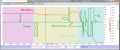
Yes, the drone wants to descend but you can fight that by giving it enough throttle and you did around 1237 sec to 1244 sec and the drone climbed. But for the remainder of the autoland you gave it either too little throttle or none.

Below are charts produced from the csv downloaded from the Phantomhelp page.
Height vs throttle and
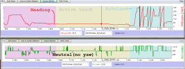
heading ( the direction in which the drone was pointing ) vs the commanded Yaw.

They also suggest to me that in the autoland you had control of the drone and if
a) you had headed for the bank you probally would have had enough height to reach the bank, or
b) you had given the drone enough throttle you could have maintained height long enough to reach the bank and maybe made it a fair way home.

If others agree with the above I think that cancelling the low battery RTH and the lack of appropriate commands during the autoland portion of the flight will be considered as pilot error. I do not know if the active track thing will mitigate that. But I would suggest you consider fishing for the drone, you probably have a fairly good location on it. Why? Because if DJI consider this pilot error and you have no drone to return you could well be out of luck i.e. no care refresh.
Would the water be warm, safe and shallow enough to snorkel?

One other thing has just come to mind, changing the flight mode on the controller might have knocked the drone out of active track. You would need to check that or have someone else confirm it but I have had to do the same thing when I couldn't remember how to cancel and intelligent flight mode with a Mavic 2 Pro or Zoom ( have only used those modes onec or twice so I am not familiar with them).
 

Attachments

  • throttle vs height.png
    throttle vs height.png
    57.6 KB · Views: 27
  • Yaw vs rudder.png
    Yaw vs rudder.png
    50.5 KB · Views: 28
Last edited by a moderator:
  • Like
Reactions: rickfmdj
You made several mistakes during this flight & the lack of knowledge over how your craft works made you panic ... you could easily have saved your MA2 but you let it descend into the water unfortunately. All this should be classified as a pilot error nothing else.

-You drained your battery way to far, deliberately canceled the Low battery RTH prompt

-You didn't know anything about the Low battery forced auto landing, when it should kick in or how to stay airborne once activated.

-You was in a semi automated flight mode (Active track) which here & there had some influence over the horizontal speed of your craft, and this would have been clearly indicated on your screen ... you could have easily got out of that by just flipping the mode switch back & forth.

-Once the Low battery forced auto landing was active you panicked ... applied all sorts of stick inputs besides the correct ones. You should have aimed your craft towards closest solid ground, applied forward speed in that direction ... & during this applied throttle for ascent to stop the auto descent.

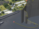
This shows the erratic & panicked flight path you commanded your MA2 to take ... red X indicate start of Low battery forced auto landing & crash into the water ...

1643015922543.png

You had 3 shorter moment of Active track in the beginning of the flight ... & one long instance starting at 1078sec into the flight which was auto cancelled when the auto landing started.

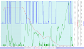
Checking off how well your stick commands actually worked in the charts below ...

Starting with the Elevator stick (right stick, forward/backward):

The slightly grayer light blue background color to the left = GPS mode with APAS active
The lighter blue background = Low battery forced auto landing active
The red graph = Height above your HP
The green graph = Heading speed
The dashed blue graph = your elevator stick command (right stick, forward/backward, value 1024 is stick neutral)

It's seen in several places before the Low battery auto landing kick in that this movement is somewhat restrained ... this due to you being in Active track mode.

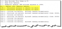
In the logs message stream we find this that could have been the reason ...

1643016754573.png
(Elevator stick vs. heading speed ... click on the chart to make it larger)
1643016224737.png

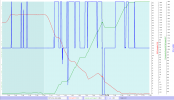
In the rudder commands we see nothing odd ... the craft responds well & accurate.

Red graph = Height again
Green graph = Adding & subtracting yaw angle
Dashed Blue graph = Rudder stick command (left stick, left/right, value 1024 is stick neutral)

(Rudder stick vs. yaw angle change ... click on the chart to make it larger)
1643016868011.png

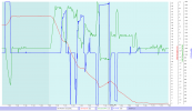
When it comes to the throttle inputs they respond as usual before the Low battery auto landing ... when the landing is active the craft will descend with neutral stick ... but slowly ascend with stick at max for ascend. It's easy to see that this you didn't know, when you do the right thing your craft gains altitude ... but you mostly didn't apply enough throttle for ascend so your craft mostly drop it's height & eventually hit the water.

Red graph = Height
Green graph = vertical speed where negative values is ascend & positive is descend
Dashed blue graph = Throttle stick command (left stick, forward/backwards, value 1024 is stick neutral)

(Throttle stick vs. vertical speed ... click on the chart to make it larger)
1643017011444.png

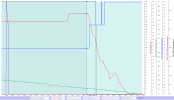
Here below the sad facts about your battery management ...

Red graph = height
Green graph = Battery percentage
Blue graph = Low battery RTH threshold in percent which is distance from HP dependent
Purple graph = Low battery RTH countdown seen on your app screen
Black graph = Low battery forced auto landing threshold in percent which is height dependent

(Click on the chart to make it larger)
1643017594155.png
 
Last edited:
Thanks all. Going to see if I can get its exact GPS location and maybe go fishing for it. Not sure how deep it is there. I typically don't canx RTH, but was using drone to locate marine mammal needing rescue. FInally found it. Everything after that....just sucked.
 
  • Like
Reactions: RMS001
...Going to see if I can get its exact GPS location and maybe go fishing for it
This is the last GPS coordinates from the log just when the RC-MA2 connection was broken when your craft went under ... & it should be the same under the "Find My Drone" function in the DJI Fly app.

1643027824816.png
 
Feel bad for you man. Whilst the detailed log explains what you did & didn’t do on your sticks, I’m sure we all would panic a little in these circumstances. Well I would anyway. I fly 95% of my flights over the Aussie coast, and every time I get my MA2 home it’s a bonus! Good luck on retrieval, and hope you’re up & flying again soon. 👍🏻
 
So sorry for your loss
 
Would the "find my drone" thing take him to the co-ordinates? I suspect so but.......
 
Feel bad for you man. Whilst the detailed log explains what you did & didn’t do on your sticks, I’m sure we all would panic a little in these circumstances. Well I would anyway. I fly 95% of my flights over the Aussie coast, and every time I get my MA2 home it’s a bonus! Good luck on retrieval, and hope you’re up & flying again soon. 👍🏻
Thanks! Needed the sympathy. So sad. I rarely fly this one but it was my first drone. Sad to have it now be an "underwater drone".
 
  • Sad
Reactions: RMS001
If you are unfamiliar with scuba diving and or the water is deep (unlikely since the water way is probably man made) be careful, also use a buddy on the surface and perhaps a tether to watch out for or warn of boats. If using a tether watch out for snagging, canals here are often dumping grounds for all sorts of things.
 
A cool, yes meeting one of those could spoil your day. I knew a scuba diver once who encountered an "huge angler fish" in murky water, it scared the 8888 out of him.
 
Feel bad for you man. Whilst the detailed log explains what you did & didn’t do on your sticks, I’m sure we all would panic a little in these circumstances. Well I would anyway. I fly 95% of my flights over the Aussie coast, and every time I get my MA2 home it’s a bonus! Good luck on retrieval, and hope you’re up & flying again soon. 👍🏻
Thank you. I can't figure out why it was in Active Track. I never use active track when flying, fly manually.
 
You made several mistakes during this flight & the lack of knowledge over how your craft works made you panic ... you could easily have saved your MA2 but you let it descend into the water unfortunately. All this should be classified as a pilot error nothing else.

-You drained your battery way to far, deliberately canceled the Low battery RTH prompt

-You didn't know anything about the Low battery forced auto landing, when it should kick in or how to stay airborne once activated.

-You was in a semi automated flight mode (Active track) which here & there had some influence over the horizontal speed of your craft, and this would have been clearly indicated on your screen ... you could have easily got out of that by just flipping the mode switch back & forth.

-Once the Low battery forced auto landing was active you panicked ... applied all sorts of stick inputs besides the correct ones. You should have aimed your craft towards closest solid ground, applied forward speed in that direction ... & during this applied throttle for ascent to stop the auto descent.

This shows the erratic & panicked flight path you commanded your MA2 to take ... red X indicate start of Low battery forced auto landing & crash into the water ...

View attachment 142544

You had 3 shorter moment of Active track in the beginning of the flight ... & one long instance starting at 1078sec into the flight which was auto cancelled when the auto landing started.

Checking off how well your stick commands actually worked in the charts below ...

Starting with the Elevator stick (right stick, forward/backward):

The slightly grayer light blue background color to the left = GPS mode with APAS active
The lighter blue background = Low battery forced auto landing active
The red graph = Height above your HP
The green graph = Heading speed
The dashed blue graph = your elevator stick command (right stick, forward/backward, value 1024 is stick neutral)

It's seen in several places before the Low battery auto landing kick in that this movement is somewhat restrained ... this due to you being in Active track mode.

In the logs message stream we find this that could have been the reason ...

View attachment 142546
(Elevator stick vs. heading speed ... click on the chart to make it larger)
View attachment 142545

In the rudder commands we see nothing odd ... the craft responds well & accurate.

Red graph = Height again
Green graph = Adding & subtracting yaw angle
Dashed Blue graph = Rudder stick command (left stick, left/right, value 1024 is stick neutral)

(Rudder stick vs. yaw angle change ... click on the chart to make it larger)
View attachment 142547

When it comes to the throttle inputs they respond as usual before the Low battery auto landing ... when the landing is active the craft will descend with neutral stick ... but slowly ascend with stick at max for ascend. It's easy to see that this you didn't know, when you do the right thing your craft gains altitude ... but you mostly didn't apply enough throttle for ascend so your craft mostly drop it's height & eventually hit the water.

Red graph = Height
Green graph = vertical speed where negative values is ascend & positive is descend
Dashed blue graph = Throttle stick command (left stick, forward/backwards, value 1024 is stick neutral)

(Throttle stick vs. vertical speed ... click on the chart to make it larger)
View attachment 142548

Here below the sad facts about your battery management ...

Red graph = height
Green graph = Battery percentage
Blue graph = Low battery RTH threshold in percent which is distance from HP dependent
Purple graph = Low battery RTH countdown seen on your app screen
Black graph = Low battery forced auto landing threshold in percent which is height dependent

(Click on the chart to make it larger)
View attachment 142549
One question....could you see if where it went down, there's anything at the surface. Looks like the red X covers that up anyway, and resolution not great.
 
One question....could you see if where it went down, there's anything at the surface. Looks like the red X covers that up anyway, and resolution not great.
Never mind.... guess its not a "real picture" with the red X. Never had one go down before, so all new to me.
 

DJI Drone Deals

New Threads

Forum statistics

Threads
134,565
Messages
1,596,302
Members
163,065
Latest member
kyle465
Want to Remove this Ad? Simply login or create a free account