DJI Mavic, Air and Mini Drones
Friendly, Helpful & Knowledgeable Community
Join Us Now

Mavic Mini 2 Mapping

dronerangerpro

New Member
Joined
Feb 19, 2018
Messages
3
Reactions
0
Age
69
Does anyone have any recommendations for flying grids and/or creating images for land? I used to do it with DroneDeploy when I had my Mavic and just looking for anything similar
 
Does anyone have any recommendations for flying grids and/or creating images for land?
If you want to automate it, you’ll need to wait for DJI to release the SDK. After that, Dronelink should work with the Mini 2 (it already works well with the Mini 1) and has a mapping option amongst many other features:

 
  • Like
Reactions: zeusfl
Does anyone have any recommendations for flying grids and/or creating images for land? I used to do it with DroneDeploy when I had my Mavic and just looking for anything similar
DroneDeploy will work properly when/if DJI get around to releasing their SDK for the Mini 2.
In the meantime, use a drone that's already supported by the mapping apps, but the Mini 2 isn't going to work with any of them.
 
I use the MPP to map, probably done over 50,000 acres. Dronedeploy for the automation/ flight plan, then I take the photos in lightroom and fine tune, followed by using metashape to create the orthomosaic which gives me a geotiff and kmz. I then use the geotiff and run gdal2tiles (which produces the best results IMO) to create all of the tiles for the different zoom levels. Once all thats done I use leaflet for displaying the info on a web browser which sits on my webserver (I don't use Dronedeploy, too pricy). Result is super high res "sat" imagery .

Not sure using the mini for mapping would be wise, doesn't seem sturdy enough for mapping, unless you're doing really small areas.
 
  • Like
Reactions: RiderATX
Not sure using the mini for mapping would be wise, doesn't seem sturdy enough for mapping
What do you mean by sturdy? Why would it need to be more sturdy to be used for mapping?
 
What do you mean by sturdy? Why would it need to be more sturdy to be used for mapping?
The heavier drones like the Mavic Pro 1/2 aren't as susceptible to wind gusts as the mini. Also, the higher top speed is beneficial when taking hundreds of photos in a high wind environment at altitude.
 
I agree that Mavic Mini wouldn't be the ideal tool for doing 50,000 acres! Definitely impressed that you accomplished that with any multi-rotor drone. The Mini is fantastic for mapping small sites such as construction sites, landfills, stockpiles etc. The results have been pretty accurate too in our tests.

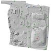
Hillshade-Check-Points.jpg
Drone hill shade with GPS Check Points showing high accuracy results
In the image above green points are within 5 cm (2″). Next, blue points are within 10 cm and finally the single red point has a difference greater than 10 cm.

The mean difference was -1.4 cm and the RMSE was 4.8 cm. These results where better than expected and provided the landfill operator with great confidence in the drone mapping.
For more read here.
How Accurate is Mapping with the DJI Mavic Mini?

Cheers
Luke
 

DJI Drone Deals

New Threads

Forum statistics

Threads
134,743
Messages
1,598,137
Members
163,243
Latest member
raj studio
Want to Remove this Ad? Simply login or create a free account