


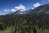
On Thursday, we drove 2 hours southward from Big Sky,MT. , past Yellowstone, to the Montana/Idaho border. The states are separated at this point by the beautiful Centennial Mountain Range, pictured here in regular, and panoramic views from the air (Mavic 2 Pro drone). The valley is a vast open space of thousands of acres, mostly privately owned huge ranches and ranch houses.
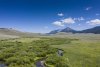
Running through this valley is the Red Rock River, where we spent the day fly fishing. (I am happy to report catching several brook trout, a rainbow trout, and a whitefish-all released back to the river).
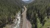
A final image shows the beautiful canyon road, route 191 running north/south from Bozeman to Yellowstone, following the course of the spectacularly beautiful Gallatin River. Shown in this aerial view is “House Rock”. This is a considerable danger and risk to the hundreds of kayakers and rafters that run this river in 3-4 large commercial groups every day.
The final picture is the Red Rock River that we walked and waded (fishing waders). You need to click separately on the two panoramas to open them.
Hope you enjoy.
Dale
Running through this valley is the Red Rock River, where we spent the day fly fishing. (I am happy to report catching several brook trout, a rainbow trout, and a whitefish-all released back to the river).
A final image shows the beautiful canyon road, route 191 running north/south from Bozeman to Yellowstone, following the course of the spectacularly beautiful Gallatin River. Shown in this aerial view is “House Rock”. This is a considerable danger and risk to the hundreds of kayakers and rafters that run this river in 3-4 large commercial groups every day.
The final picture is the Red Rock River that we walked and waded (fishing waders). You need to click separately on the two panoramas to open them.
Hope you enjoy.
Dale
Attachments
Last edited:

")

") I never did a panoramic photo, I am rather a movie maker! I think that with a drone there is no way to shoot vertical images. It could be an option to fix a Hero7 vertically underneath the drone!
I never did a panoramic photo, I am rather a movie maker! I think that with a drone there is no way to shoot vertical images. It could be an option to fix a Hero7 vertically underneath the drone!


