I'm going to try to sneak in a comment about my Avata although I know there's a separate forum....and mention that I tossed my Avata up in a gorge where the winds got funneled and it was immediately blown back and I had to bring it down. I tested it again, bringing it up and was shocked that the results were the same. I tend to think my my Avata like my FPV but the only similarity is they both use goggles. My FPV and Mavic 3 would have handled that wind (whatever it actually was) with no problem but no surprisingly the Avata did not. I need to start taking my Mini 3 pro along on some of these jaunts to play with wind resistance. Too bad there isn't a web site where people can post...oh...never mind.
You are using an out of date browser. It may not display this or other websites correctly.
You should upgrade or use an alternative browser.
You should upgrade or use an alternative browser.
Oh them high winds!
- Thread starter akdrone
- Start date
You just didToo bad there isn't a web site where people can post...oh...never mind.
May have been some micro bursts
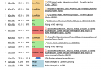
I came quite close to the same situation yesterday in the Columbia River Gorge with my Mavic 3. Wind gusts were around 30mph at ground level and likely well above that above the treetops. This is part of my AirData log from that flight:

I was able to safely land manually but it was unnerving to watch my drone going sideways in the wind 3 feet off the ground. My flight lasted just long enough to grab a few still images of a waterfall and then get it back down out of the sky.
I now know my upper limits for flying in the wind.

I was able to safely land manually but it was unnerving to watch my drone going sideways in the wind 3 feet off the ground. My flight lasted just long enough to grab a few still images of a waterfall and then get it back down out of the sky.
I now know my upper limits for flying in the wind.
Last edited:
Chrislaf
Well-Known Member
What was the highest wind speed that AirData was reporting for your flight?I came quite close to the same situation yesterday in the Columbia River Gorge with my Mavic 3. Wind gusts were around 30mph at ground level and likely well above that above the treetops. This is part of my AirData log from that flight:
View attachment 161691
I was able to safely land manually but it was unnerving to watch my drone going sideways on the wind 3 feet off the ground. My flight lasted just long enough to grab a few still images of a waterfall and then get it back down out of the sky.
I now know my upper limits for flying in the wind.
Chris
Where would AirData show me the wind speed? I looked around for that but had to settle for a Weather Underground station about a mile from where I was trying to fly.What was the highest wind speed that AirData was reporting for your flight?
Chris
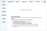
Edit - I found the InFlight Wind info but it says "Not enough valid records were found."
Chrislaf
Well-Known Member
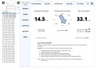
Actually I have a Gold account but in this case I yanked the drone down almost immediately when it became clear that I would likely lose control of it if I didn't. Here is the screen from my AirData display:You should just be able to click on your particular flight in the flight Overview>Weather>InFlight Wind and you should see the Max Gust Speed
Here’s what it looks like for me
I have a Gold account. Just realized that you need at least an HD 360 plan so that is likely the problem.
Chris

My Mavic 3 was only airborne for 1 minute 19 seconds as shown in the log in post #3. Total horizontal distance for the flight was 22ft (@65ft. AGL) and that was entirely due to the wind.
hiflyer201
Well-Known Member
- Joined
- Sep 27, 2018
- Messages
- 2,740
- Reactions
- 2,167
Similar threads
- Replies
- 23
- Views
- 2K
- Replies
- 13
- Views
- 2K
- Replies
- 7
- Views
- 2K
DJI Drone Deals
New Threads
-
-
Smart Controller with Alientech Mod now "RC needs calibration" & 30064
- Started by jtz54
- Replies: 1
-
Mini 5 Pro Uvita Beach Costa Rica Fantastic Sunset
- Started by spamgnome
- Replies: 1
-
Are DJI Drones Now More Available Than Before the 'Ban'?
- Started by moldorf
- Replies: 2
-


