DJI Mavic, Air and Mini Drones
Friendly, Helpful & Knowledgeable Community
Join Us Now

2 Pro The Mississippi river is our county line, and Clearwater river, here in Minnesota and Wright county

MavicFlyer2

Well-Known Member
Premium Pilot
Joined
May 1, 2021
Messages
674
Reactions
1,614
Location
Minnesota
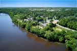
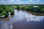
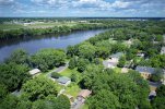
Wright County MN has many miles of water that are used as our county borders. The Mississippi river is the northern most county line and starts at Clearwater and end up at Dayton. Here’s a trip southeast from Clearwater to Monticello, Otsego and then Dayton.
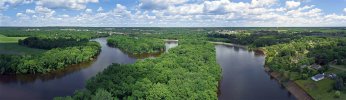
In Clearwater, the Clearwater river comes up from the south to join the Mississippi as the northern most point in the county. In Dayton, the Crow river comes up from the south which forms the northeastern corner or the county.
 

Attachments

  • 001.jpg
    001.jpg
    1.7 MB · Views: 28
  • 002.jpg
    002.jpg
    1.6 MB · Views: 23
  • 003.jpg
    003.jpg
    2.2 MB · Views: 21
  • 004-1.jpg
    004-1.jpg
    1,014.9 KB · Views: 20
  • 005.jpg
    005.jpg
    1.9 MB · Views: 21
  • Elk River.jpg
    Elk River.jpg
    944.1 KB · Views: 22
Awesome photos of the Mighty Mississippi.
 
  • Like
Reactions: sarahb
Awesome photos of the Mighty Mississippi.
Thank you....we live in an area here in Minnesota with many lakes, rivers and creeks. Our whole north side and east side, except a small fraction on the southeast corner, the rivers are our borders.
 
  • Like
Reactions: GFields
Lycus Tech Mavic Air 3 Case

DJI Drone Deals

New Threads

Forum statistics

Threads
132,301
Messages
1,571,759
Members
161,019
Latest member
dugan