DJI Mavic, Air and Mini Drones
Friendly, Helpful & Knowledgeable Community
Join Us Now

Waypoint or location map

KingRat

Well-Known Member
Joined
May 27, 2020
Messages
440
Reactions
516
Age
63
Location
England
Idiot alert.... I have been flying manually quite happily for photography for a while and because of this I have always had the camera view on the tablet screen. I have a project I am going to work on that requires being able to put the camera in exactly the same place, altitude and position and camera angle (easy, straight down) each time. I thought waypoints would be the ideal method of doing this. I only need the one. Fly into position and save the waypoint..... I rode to my project site, nothing exciting, a clump of trees, which is a good hours ride away involving unmade tracks and across a couple of fields too. Got the picture framed, took todays shot, a couple of variations, and then went to save the waypoint. Controller symbol, no problem, waypoint wiggly symbol, no problem.... that was when I discovered I have no map in my DJI control app (Mavic Pro 2). Everything else has worked perfectly so far and I only found out today when I went to make a blue mark on the map - I have the home H in it's little green circle, I have the red arrowhead that is the drone and it's orientation - but the map is totally white, there is no actual map to see.

Please? What have I done / have to do to be able to see the map and be able to make a waypoint flight route?

Before you reply - WARNING, I am a complete computer numpty and I have only just got the tablet to fly with, I don't know how to use it for anything else. I don't use it for anything else, not pictures, not faecesbook NOTHING - it is purely my controller screen. So go gently and if you think your reply is too simplistic for a 3 year old, it will probably be way over my head!
I have no answer but must comment that “numpty” is a great word. I am adding it to my vocabulary.Thank you !
 
Idiot alert.... I have been flying manually quite happily for photography for a while and because of this I have always had the camera view on the tablet screen. I have a project I am going to work on that requires being able to put the camera in exactly the same place, altitude and position and camera angle (easy, straight down) each time. I thought waypoints would be the ideal method of doing this. I only need the one. Fly into position and save the waypoint..... I rode to my project site, nothing exciting, a clump of trees, which is a good hours ride away involving unmade tracks and across a couple of fields too. Got the picture framed, took todays shot, a couple of variations, and then went to save the waypoint. Controller symbol, no problem, waypoint wiggly symbol, no problem.... that was when I discovered I have no map in my DJI control app (Mavic Pro 2). Everything else has worked perfectly so far and I only found out today when I went to make a blue mark on the map - I have the home H in it's little green circle, I have the red arrowhead that is the drone and it's orientation - but the map is totally white, there is no actual map to see.

Please? What have I done / have to do to be able to see the map and be able to make a waypoint flight route?

Before you reply - WARNING, I am a complete computer numpty and I have only just got the tablet to fly with, I don't know how to use it for anything else. I don't use it for anything else, not pictures, not faecesbook NOTHING - it is purely my controller screen. So go gently and if you think your reply is too simplistic for a 3 year old, it will probably be way over my head!
You can go to the Waypoints 2 app on the DJIGo4 app and bring up the map while you are sitting in your comfortable desk at home, days before your shoot. You can adjust all of the parameters (pathway, height at each point, etc.) and save it to you file. Then, when you arrive at the site of your shoot, you can retrieve the saved route and activate it with the GO button. There are several You Tubes on this. Just search You Tube for Waypoints 2.Screen Shot 2021-06-06 at 9.23.56 AM.png
 
  • Like
Reactions: KingRat
You can go to the Waypoints 2 app on the DJIGo4 app and bring up the map while you are sitting in your comfortable desk at home, days before your shoot. You can adjust all of the parameters (pathway, height at each point, etc.) and save it to you file. Then, when you arrive at the site of your shoot, you can retrieve the saved route and activate it with the GO button. There are several You Tubes on this. Just search You Tube for Waypoints 2.View attachment 130311

It is through watching those tutorials that gave me the idea of using the waypoint feature.... I can't get the map to do the at home thing...... let alone the map once out on site.
 
It is through watching those tutorials that gave me the idea of using the waypoint feature.... I can't get the map to do the at home thing...... let alone the map once out on site.
You really need to carefully study the middle one I sent. All of the information you will need is there. I can send 2 or 3 recent waypoints using this technique. Here is one, purely controlled by the pre-planned program. I never touched the sticks after hitting the go button. I did a rectangular route around this lake with the fountain as the point of interest. The gimbal followed the fountain and kept it mostly in the center.
 
  • Like
Reactions: KingRat
You really need to carefully study the middle one I sent. All of the information you will need is there. I can send 2 or 3 recent waypoints using this technique. Here is one, purely controlled by the pre-planned program. I never touched the sticks after hitting the go button. I did a rectangular route around this lake with the fountain as the point of interest. The gimbal followed the fountain and kept it mostly in the center.

Thank you. I will have another look. Spent all day charging and updating both drones, all batteries and both controllers. I have reinstalled Go4 on both tablets too - covering all bases. I am ready to try again now, knowing full well that everything is up to date.
 
Thank you. I will have another look. Spent all day charging and updating both drones, all batteries and both controllers. I have reinstalled Go4 on both tablets too - covering all bases. I am ready to try again now, knowing full well that everything is up to date.
Of course I am assuming you are flying the Mavic 2 Pro. I cannot vouch for any other drone of which I am totally unfamiliar.
 
You will need to connect to wifi (or have a sim card onboard) to download the map for area you are going to.
Remember to zoom in to at least resolution you want while connected to internet.
 
  • Like
Reactions: 1TenaciousG
Thank you. I will have another look. Spent all day charging and updating both drones, all batteries and both controllers. I have reinstalled Go4 on both tablets too - covering all bases. I am ready to try again now, knowing full well that everything is up to date.
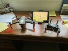
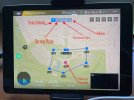
Here are two images which will give you a great image of how the program works. I am programming my future flight from my desk. Noe that I have programmed 7 points, and a point of interest. The way points are blue dots and the POI is a red marker. Also note that the height of each way point can be set, and that the way points blue marks are pointing to the way point. It really helps to have an iPad for this.

Dale
Programming Waypoints 2.0 from my desk.jpgA typical way point routing.jpg
 
  • Like
Reactions: KingRat
What I like using Litchi (have mavic pro) is that I can easily record waypoints during a flight. After that, we can polish details (actions). Moreover, the uav will perform with Litchi the mission even if deconnection occurs. About map, just put the phone or pad in data (assuming it has geolocalisation activated) the time needed to record it... Hope my answer can help.
 
Here are two images which will give you a great image of how the program works. I am programming my future flight from my desk. Noe that I have programmed 7 points, and a point of interest. The way points are blue dots and the POI is a red marker. Also note that the height of each way point can be set, and that the way points blue marks are pointing to the way point. It really helps to have an iPad for this.

Dale
View attachment 130331View attachment 130330
Thanks Dale, your help is appreciated.
I notice you have the drone turned on and connected..... I have just been using the tablet on it's own. Those tutorials don't tell you to turn the drone on IN THE HOUSE. I didn't realise it needed to be, I thought the controlling programme was in the tablet and that it would pass the information to the aircraft once it was all connected outside.... I wonder if that is the problem, but I should still have the map even without the drone turned on, surely?

UPDATE: I have found the maps, but they are very limited to area, about 3 miles square, or am I going in too close?
 

DJI Drone Deals

New Threads

Forum statistics

Threads
131,096
Messages
1,559,822
Members
160,080
Latest member
KevinStudent