


Hi all- I'm a professor/weather researcher at the University of North Dakota who also dabbles in the UAS space. One of the limitations we've seen with current forecasting applications is the lack of uncertainty in short-term forecasts and availability of both forecast and real-time data in one place. We received funding through the FAA ASSURE program and their partners to develop an open/free forecast platform for weather forecasts and I'm proud to introduce our platform in this post! For those of you who are in the US, I'd love to have you try it out. A brief overview of what the application provides and how to use it is below. Also- big thanks to the dronepilots team for clearing us to share this with you!
The application:
ASSURE UAS Forecast
The details:
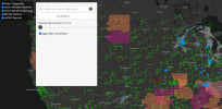
When you first open the application, you enter a screen that looks like:


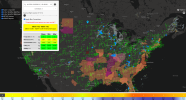
The colors will change based off the platform you choose (we just used their default specs). You are probably better off choosing custom wind values based off of your comfort with piloting!
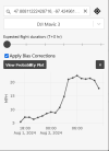
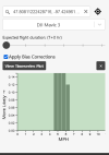
Based on an initial survery of UAS users, we provide parameters such as precipitation, winds and gusts, ceiling, and visibility. We include a range in values to help you judge how much uncertainty there is in the forecast. The 'Apply Bias Corrections' button is something that corrects wind variables under certain situations based off forecast verification we have performed in the past. In most cases, you probably won't notice a difference. If you click on the little graph icon, you will get additional plots that show the range in values expected and a time-series of the variables:


For this case, you can see the bottom bar in the main application turns orange due to stronger winds expected later in the period. The white/blue colors indicate day/night.

Note that the application is still in development and the biggest thing we need to implement is a conversion of the rainfall intensity to a probability. We also know the model can struggle with some precipitation, so we are generating an approach that combines both current radar and model data to give you the best estimate of precipitation risk. The forecasts you request are anonymously saved (no tracking info), and we actually use this information to test the skill of the model. Try it out, and let us know what what you think. We know there are probably some bugs still out there, and any feedback will help! I will be monitoring this thread and I'm happy to answer *any* weather and weather forecasting questions you have.
The application:
ASSURE UAS Forecast
The details:
When you first open the application, you enter a screen that looks like:
- Radar composite data comes from blended radar data provided by the National Severe Storms Laboratory. This will allow you to quickly see where precipitation is falling (but watch out in areas near mountains where radars can miss storms!).
- Active watches and warnings from the National Weather Service. If you double click on a point to make a forecast, it will show a hazard icon if you are inside of a hazard. Click this to get more details.
- METAR stations- standard surface weather observations typically located at airports. Temperature, dewpoint, pressure, and the wind barb are shown.
- mPING reports - crowdsourced observations by people reporting weather. This can help in areas where the precipitation is shallow or blocked by terrain and unseen by radar.
The colors will change based off the platform you choose (we just used their default specs). You are probably better off choosing custom wind values based off of your comfort with piloting!
Based on an initial survery of UAS users, we provide parameters such as precipitation, winds and gusts, ceiling, and visibility. We include a range in values to help you judge how much uncertainty there is in the forecast. The 'Apply Bias Corrections' button is something that corrects wind variables under certain situations based off forecast verification we have performed in the past. In most cases, you probably won't notice a difference. If you click on the little graph icon, you will get additional plots that show the range in values expected and a time-series of the variables:
For this case, you can see the bottom bar in the main application turns orange due to stronger winds expected later in the period. The white/blue colors indicate day/night.
Note that the application is still in development and the biggest thing we need to implement is a conversion of the rainfall intensity to a probability. We also know the model can struggle with some precipitation, so we are generating an approach that combines both current radar and model data to give you the best estimate of precipitation risk. The forecasts you request are anonymously saved (no tracking info), and we actually use this information to test the skill of the model. Try it out, and let us know what what you think. We know there are probably some bugs still out there, and any feedback will help! I will be monitoring this thread and I'm happy to answer *any* weather and weather forecasting questions you have.
Attachments
-
 Screenshot 2024-08-01 at 13-27-41 ASSURE UAS Forecast.png497.8 KB · Views: 6
 -
 Screenshot 2024-08-01 at 13-53-43 ASSURE UAS Forecast.png1 MB · Views: 5
 -
 Screenshot 2024-08-01 at 13-40-32 ASSURE UAS Forecast.png23.5 KB · Views: 5
 -
 Screenshot 2024-08-01 at 13-40-24 ASSURE UAS Forecast.png19.1 KB · Views: 5


