

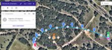
I would like to thank DroneLink for being willing to demonstrate their mission planning capability by importing a new type of drone flight path - a log-spiral curved flight path intended to produce a more dramatic video entry sequence of waypoints. DroneLink specified the launch point; and I chose the target point - two points are required to construct the log-spiral flight path waypoints file (csv and/or kmz file). A characteristic of each log-spiral curved flight path is a constant tangent angle which is maintained throughout the entire length of the trajectory segment - that is the camera yaw angle remains constant throughout the flight path and is pointed toward the target. At the end of the video entry sequence, other DroneLink features could be added - POI or orbit. I appreciate DroneLink's time and consideration.

Who/How/Why -- do you trust non-DJI automation apps? (Litchi, DroneLink, DroneDeploy, etc...)
- Thread starter Firejay27
- Start date


")
Similar threads


DJI Drone Deals
New Threads
-

-
 Avatar: Fire and Ash Drone Light Show.
- Started by The Droning Company
- Replies: 0
-
Globalstar and Skydio Trial Validates D2D for Drones.
- Started by The Droning Company
- Replies: 0
-
-
Northrop Grumman AION Tackles Drone Threats.
- Started by The Droning Company
- Replies: 0
Forum statistics
