


Recent content by aerialphotosbrisbane
-

Can one udate firmware of controller only using DJI Assistant2
thanks msinger, the update info is good to know, I had a reply from PrecisionHawk that its okay to bypass the error message and fly. Pissing with rain here at the moment. When the weather clears, I will try PrecisionMapper on a small field.- aerialphotosbrisbane
- Post #5
- Forum: Mavic Pro
-
More MavicPro drone mapping success with DroneDeploy
I have been using the MavicPro for drone mapping and am keen to share the story and get a discussion going about drone mapping. I have used DroneDeploy to control the drone and its works so well. Fell free to chip in about projects, case studies done, I would like to see other mapping work. I...- aerialphotosbrisbane
- Thread
- Replies: 8
- Forum: General Discussions
-
Can one udate firmware of controller only using DJI Assistant2
Thanks 4wd, when the mavic does a firmware upgrade, I asseme the controller and battery in at the moment have a firmware upgrade as well ?- aerialphotosbrisbane
- Post #3
- Forum: Mavic Pro
-
Used DroneDeploy to map a quarry
thanks, I will try that on a short, low, slow run- aerialphotosbrisbane
- Post #47
- Forum: General Discussions
-
Used DroneDeploy to map a quarry
good to know :)- aerialphotosbrisbane
- Post #46
- Forum: General Discussions
-
Can one udate firmware of controller only using DJI Assistant2
I am using PrecissionMapper with the mavicpro on my Ipad, (for drone mapping) A warning comes up saying the drone's firmware has to be updated to 1.3.5 using Inflight (??). ... the current controller version is 01.03.0500. I did a firmware upgrade via the ipad and all was good. but...- aerialphotosbrisbane
- Thread
- Replies: 4
- Forum: Mavic Pro
-
Used DroneDeploy to map a quarry
Hi Mark, So you take off using DJI Go app, get the MavicPro to the desired height, focus, while still flying exit DJI Go app and run Drone Deploy? I am just interested if this is your approach? Thanks- aerialphotosbrisbane
- Post #40
- Forum: General Discussions
-
Intro to MavicPro drone panorama photography
Hi fellow Mavic Pilots. I have been doing a crazy amount of panorama photography recently with the MavicPro and wrote up an introduction with some examples here MavicPro Drone Panorama Photography - DroneAce Brisbane. I do a lot of aerial cityscapes and found the fixed focal length to be...- aerialphotosbrisbane
- Thread
- Replies: 3
- Forum: Mavic Pro
-
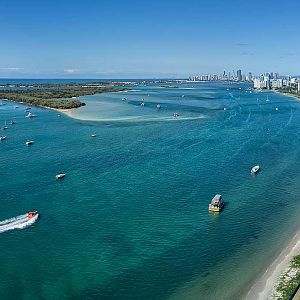
Gold-Coast-Broadwater-aerial-drone-panorama-photography-DroneAce
Aerial panorama photography on the Gold Coast, Australia - DJI MavicPro- aerialphotosbrisbane
- Media item
- Comments: 1
- Album: aerialphotosbrisbane
-
Used DroneDeploy to map a quarry
Hi TexInPa, welcome to the discussion, its great to have you contributing. To answer your question on mission flight times, I have read that 10-2 is the best time to minimize shadows (but then more chance of wind). I have not used Maps made Easy yet, any thoughts on how well it performs. I might...- aerialphotosbrisbane
- Post #37
- Forum: General Discussions
-
MavicPro drone mapping write up
Thanks for the feedback, Aerial Perceptions, you can toggle the DroneDeploy to have the camera shoot either manual or automatic. My first run had the setting on auto and all my images where overexposed. I am not sure if the setting has always been available- aerialphotosbrisbane
- Post #4
- Forum: General Discussions
-
Used DroneDeploy to map a quarry
I wrote a blog post about this on my website and the images I took are available to download and use in your photogrammetry software of choice. MavicPro Drone Mapping | Brisbane quarry | DroneDeploy | Pix4D | Point cloud | Orthomosaic |DEM | 3D model- aerialphotosbrisbane
- Post #35
- Forum: General Discussions
-
MavicPro drone mapping write up
I just finished a write up for my blog how I use the MavicPro fro drone mapping a quarry in Brisbane, Australia. http://www.droneace.com.au/project/mavicpro-drone-mapping/ The images I used are available at the end of the blog post. Any feedback welcome. cheers- aerialphotosbrisbane
- Thread
- Replies: 3
- Forum: General Discussions
-
Used DroneDeploy to map a quarry
TLT, what photogrammetry software do you advise to use and why not the cloud, too much time to upload?- aerialphotosbrisbane
- Post #25
- Forum: General Discussions
-
Used DroneDeploy to map a quarry
Hey TLT.. thanks for adding in, it would be great to get help from you. Photogrammetry is an amazing field for me that I want to move into and learn more about. I did not know that you could be certified in photogrammetry. Is that a States (USA) based thing. Apart from all the new terminology...- aerialphotosbrisbane
- Post #21
- Forum: General Discussions