DJI Mavic, Air and Mini Drones
Friendly, Helpful & Knowledgeable Community
Join Us Now

400' AGL... off the top of a hill

  • Thread starter FormerMember06292019_2
  • Start date
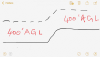
Fortunately the DJI designers imagined that (just like a real plane) there could be situations where a drone is flown from a high point down to lower altitudes.
It makes no difference to the drone whether the altitude has a + or - in front of it.

Isn't there a negative 200-foot limit? The Mavic won't descend more than 200 feet below the takeoff point?
 
Right, exactly, I was just making the point between GPS and barometric altitude.

Agreed. I made some GPS AMSL vs. barometric measurements for a different purpose, but it demonstrates the relative accuracies:

 
  • Like
Reactions: AMann
Isn't there a negative 200-foot limit? The Mavic won't descend more than 200 feet below the takeoff point?

No - that's a waypoint restriction in Litchi if you are not setting waypoints AGL, but there is no restriction in the aircraft firmware.
 
GPS altitude, 10+ years ago(?), when the gov't introduce error on purpose, was indeed rather unreliable...esp with the GPS receivers of those days...but these days, GPS altitude is quite accurate.

The best idea would be to use GPS altitude above, oh 30 feet AGL, and then use the barometer for precision landing.

The GPS altitude error has nothing to do with selective availability, it is due to satellite geometry relative to the GPS. The way the system triangulates position from satellite signals is that vertical measurements are more difficult to triangulate than horizontal, and require much more precise timing.

I’ve been using survey grade GPS systems (accurate to more than +- 1cm) in “those days” and “these days”, and elevation measurements are no different than they used to be, even with differential correction. Consumer grade GPS units can’t measure elevation as accurately as a good barometric based system, but survey grade GPS units can.
 
The GPS altitude error has nothing to do with selective availability, it is due to satellite geometry relative to the GPS. The way the system triangulates position from satellite signals in that vertical measurements are more difficult to triangulate than horizontal, and require much nor precise timing.

Ive been using survey grade (accurate to more than +- 1cm) in “those days” and “these days”, and elevation measurements are no different than they used to be, even with differential correction.

Geometrically the vertical error is, on average, 1.5 times the horizontal error. So when SA degraded the horizontal error it proportionally degraded the vertical error.
 
  • Like
Reactions: Thomas B and AMann
Geometrically the vertical error is, on average, 1.5 times the horizontal error. So when SA degraded the horizontal error it proportionally degraded the vertical error.

But it’s still measuring elevation based on the ellipsoid model and vertical datum, that and satellite geometry. The 1.5 times figure is on average, but we’ve gotten errors as much as +-100 meters with Trimble units and usually have let the units sit for as long as 10 minutes on a tripod to get an accurate elevation measurement.
 
But it’s still measuring elevation based on the ellipsoid model and vertical datum, that and satellite geometry. The 1.5 times figure is on average, but we’ve gotten errors as much as +-100 meters with Trimble units and usually have let the units sit for as long as 10 minutes on a tripod to get an accurate elevation measurement.

I've not seen an error anywhere near that large with modern equipment. Most (maybe all) modern GNSS receivers (including DJI equipment) output elevation relative to a reference geoid model, not a simple ellipsoid. If you are looking at ellipsoid heights then yes - but that's not the way it's generally done these days.
 
I've not seen an error anywhere near that large with modern equipment. Most (maybe all) modern GNSS receivers (including DJI equipment) output elevation relative to a reference geoid model, not a simple ellipsoid. If you are looking at ellipsoid heights then yes - but that's not the way it's generally done these days.

We are using Trimble Geo 7x’s ... with code differential GNSS processing it’s vertical is good to +- half a meter, but thats on point with a GNSS antenna. I doubt the DJI gps receivers are close to that.
 
We are using Trimble Geo 7x’s ... with code differential GNSS processing it’s vertical is good to +- half a meter, but thats on point with a GNSS antenna. I doubt the DJI gps receivers are close to that.

They are not, but they are good to a few meters. Anyway - are we still talking about ellipsoid/geoid offset or VDOP? First you said that you were seeing ± 100 m, and now ± 0.5 m.
 
RD+’s
They are not, but they are good to a few meters. Anyway - are we still talking about ellipsoid/geoid offset or VDOP? First you said that you were seeing ± 100 m, and now ± 0.5 m.
As bad as +- 100 meters with one rover, bad VDOP and no differential correction, the usual with those is +-O.5m with differential correction and good VDOP.

We also just got a set of Emlid Reach RS+’s, get to try them out in a couple weeks. Their vertical is supposed to be as accurate as +-10mm with differential GNSS correction on a tripod (up to 5 minutes of data collection recommended).
 
Last edited:
  • Like
Reactions: sar104
@sar104 Based on how steady a Mavic can hover, its a good thing they aren’t using GPS elevation for controlling that. You mentioned earlier how the barometer is affected by wind, local pressure and temp, which is very correct. Ive noticed how a hovering Mavic changes height slightly even with very small breezes, I wonder if that’s part due to turbulence near where the barometer port is in the body. It would be fun to be able to directly blow air at the barometer port to see how it changes hovering height.
 
Last edited:
Some test questions:

I. You are on top of a 400’ hill, and want to fly up another 400’ above it. The airport in the valley 400’ below you has Class E airspace starting at 700’ above it and extends over your hill. Can you fly another 400’ up from the top of the hill and still be in uncontrolled airspace?
Here is my understanding of the direct answer to your direct question. If Class E starts at 700', that means above the level of the airport. If you are 400' above the airport, you can go up another 300' and still be in class G. Above that is Class E.;
 
This made a lot of sense to me when learning the 400' AGL rule. Attach an imaginary string 400' long to the bottom of your drone. As long as it touches the ground you're good. Of course, there are variables to this thought. For example, flying over towers and other objects. I haven't needed my 107, but I learned a lot studying for it.
 
@sar104 Based on how steady a Mavic can hover, its a good thing they aren’t using GPS elevation for controlling that. You mentioned earlier how the barometer is affected by wind, local pressure and temp, which is very correct. Ive noticed how a hovering Mavic changes height slightly even with very small breezes, I wonder if that’s part due to turbulence near where the barometer port is in the body. It would be fun to be able to directly blow air at the barometer port to see how it changes hovering height.

They aren't using barometric either - the primary vertical control is the z-axis accelerometer, with the barometer as a slower reference correction.
 
  • Like
Reactions: AMann
As Sar104 mentioned in Post #48 above, it’s terrain, not an structure you are flying near, so you’d be 400’ too high flying out to that 800’ AGL part.

Impressive place, where is that road?
Got it. Wishful thinking I guess. At least I can still fly that area... just got to keep a leash on my MP. The area shown is the road to Black Rock Reservoir above Fresno.
 
  • Like
Reactions: AMann
In general terms AGL means above ground level relative to the ground level at your location. General aviation doesn’t allow aircraft to descend below 500 feet agl and drones are limited to 400 feet agl to avoid conflict. Of course other regulations come into effect around airports and controlled airspace etc
 

Attachments

  • 611D50C4-FC0A-4202-AAC3-A46713ACD083.png
    611D50C4-FC0A-4202-AAC3-A46713ACD083.png
    2.1 MB · Views: 9
In general terms AGL means above ground level relative to the ground level at your location. General aviation doesn’t allow aircraft to descend below 500 feet agl and drones are limited to 400 feet agl to avoid conflict.
AGL doesn't refer to your location, it refers to the ground below the aircraft. They are not always the same thing.
And the simplistic idea that planes can only fly above 500 ft is a common misconception.
There are plenty of situations where it is completely legitimate for real planes to be flying below 500 ft.
 
  • Like
Reactions: AMann
If you said that, it would be incorrect as well.
If he launches from a hilltop that is 400 ft above sea level, he can climb another 400 feet and still be within regulations.
How do you think people fly at Denver?


A flight instructor buddy of mine sent me this he uses for his students as they get confused by it too:
C8FF3E0C-B27F-4A30-B448-6A6B79ED0069.jpeg
 
  • Like
Reactions: dawgpilot
Lycus Tech Mavic Air 3 Case

DJI Drone Deals

New Threads

Forum statistics

Threads
131,233
Messages
1,561,078
Members
160,185
Latest member
Tarizzman