DJI Mavic, Air and Mini Drones
Friendly, Helpful & Knowledgeable Community
Join Us Now

Almost new pilot in Savannah!

s grenald

Active Member
Joined
May 22, 2021
Messages
36
Reactions
41
Age
62
Location
Savannah, GA
Hi All! I've finally decided to take the plunge and get a "real" drone. I'm going to head over to the local Best Buy and pick up an Air 2S later today. I guess I'll also need to sign up for DJI Care. Hopefully I can figure this thing out before I destroy it. :)

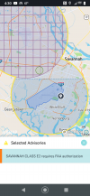
One question, though. Looking at a map, it appears that most of the city is in the Class E2 and Class D area around Hunter Army Airfield. Does this mean I need to get some sort of authorization from the FAA before I even try to fly this thing around my yard?

I'm really looking forward to getting some cool stills and video from this thing!
 
Hello from the Crossroads of America s grenald.

The AAF is off limits and the other areas will need authorization.


Screenshot_20210523-043012.png


I haven't had the opportunity to unlock a zone using the LAANC link yet, but other pilots have and it seems to work for them most of the time.


Good luck and welcome to the Forum. ?

.
 
Hi All! I've finally decided to take the plunge and get a "real" drone. I'm going to head over to the local Best Buy and pick up an Air 2S later today. I guess I'll also need to sign up for DJI Care. Hopefully I can figure this thing out before I destroy it. :)

One question, though. Looking at a map, it appears that most of the city is in the Class E2 and Class D area around Hunter Army Airfield. Does this mean I need to get some sort of authorization from the FAA before I even try to fly this thing around my yard?

I'm really looking forward to getting some cool stills and video from this thing!
Hi & Congrats on buying a “Real Drone”... I love the Mavic Series Aircraft...My first Year was not good with the Phantom series...Here are my SOP’s that I follow...and I am sure not all will agree, but it seems to be working for me...
1. If You Haven’t Already PLEASE Get Your 107 UAS PILOT LICENSE...Knowing and Playing by the Rules vs. “A Cowboy” helps us ALL!
2. Use Air Map (I use DroneUp) and I refer to it as “Filing aFlight Plan” whenever I Fly. Who You Are, Where your Flying & Estimated Flight time...submit it and it will come back with advisories for that area... but you just “CYA”... and I “File it” always under 107...and play by the Rules
3.Now this one is a Little New to me, but it is my UNDERSTANDING that Should you require a Waiver it’s no big deal, However if the Airspace you will be flying in has different Altitude Levels, the Waiver will be issued to fly @ the LOWEST LEVEL ONLY...You Can’t Be in 50ft airspace, Transition to 100 foot airspace and climb...You Are Restricted to 50 Feet max altitude per the Waiver...
4.This will get it going...It is My Understanding that whoever’s Airspace that you are going to be operating in Needs to be advised by You, the PIC that you have a Waiver and will be operating in their Airspace. Once Completed, call them back and advised that you are done. In the Class D airspace it will be a Tower...Most of them answer in a somewhat Grumpy Fashion, but that’s just a Controller!(But Great People!)...The Rule is tell them 1. Who You Are 2. Where Your At 3. What Your Doing & Will Advise once Completed. Now he will put on the ATIS Notams “Pilots use Caution for Drone Operations in Affect 150agl feet & below 2.0 East of the Airport”...Again, the Corner Stone is Safety, but “CYA” is as equally important!
5. Finally, if confused...CALL THE FAA and Ask! (Preferably Your local Flight District Standards Office or FSDO)...and yes, you’ll get different answers from them as well!

Hey I hope I helped...@ the Minimum I probably just stirred the “Hornets Nest”..lol
 
Thanks! That was the image I was looking at. I think LAANC can be used for the area near the Savannah airport (the purple circle with the grid in the upper left) but Hunter isn't a LAANC airport (or whatever the term for it is). I live in the blue circle. So I'll need to get FAA authorization for ANY kind of flying, even if my back yard, right? Is that a one-time thing? Or do I have to file a flight plan every time I want to take the drone out?

I MAY do some commercial work eventually, so I'd need to get a 107 certificate, but for now, I'd just want to fly to get proficient with the drone.
 
I think the unlocking of DJI's geo fencing may last for a period of time and I'm not sure about LAANC.

I haven't had an opportunity to try to unlock anything in all my years of flying as I'm in Class G airspace most of the time.

Do a search of this Forum and / or YouTube for instructions on how to do it.

.
 
Welcome to the forum. We look forward to your participation and your view of the world.
 
Hi All! I've finally decided to take the plunge and get a "real" drone. I'm going to head over to the local Best Buy and pick up an Air 2S later today. I guess I'll also need to sign up for DJI Care. Hopefully I can figure this thing out before I destroy it. :)

One question, though. Looking at a map, it appears that most of the city is in the Class E2 and Class D area around Hunter Army Airfield. Does this mean I need to get some sort of authorization from the FAA before I even try to fly this thing around my yard?

I'm really looking forward to getting some cool stills and video from this thing!
Welcome to Mavic Pilots from Dayton Ohio USA! Fly safe and have fun!
 
Flown in Savannah - at the Riverwalk, Courthouse, Tybee Island, and many of the parks with zero issues.

Flying near any military base is usually 100% OFF LIMITS, esp if they have aircraft coming in and out.
Yeah, I get that. The problem is, if you look at that map above my house is in the upper part of the lower blue circle. From a "real world" point, I don't have aircraft flying over my house. The airport approaches are East & West of the airport (the base is the dark blue area on the map, and it's a forbidden zone), and I'm to the North. But I'm still in the blue circle. Not that I have a huge yard or anything, but if you told me that I had to get into my car and drive a few miles from my house just to even practice basic maneuvers, that might be a deal killer.
 
I'd also suggest looking at 3rd Party Insurance thru a company like State Farm instead of DJI. Typically cheaper, they are local (so maybe faster on ponying up), and tend to cover way more crashes / losses than DJI.
I was reading some of the comments elsewhere on the boards here. It sounds like DJI is $100 for one year, $180 for two, or $100 + $90 if you buy the second year separately. State Farm is $60-80/year. I think I'd go with DJI for the first two years, and then maybe attach it to my homeowners after that. Or maybe by then I'll have an Air3z or something, and the Air2S will be long sold. :)
 
Hi & Congrats on buying a “Real Drone”... I love the Mavic Series Aircraft...My first Year was not good with the Phantom series...Here are my SOP’s that I follow...and I am sure not all will agree, but it seems to be working for me...
1. If You Haven’t Already PLEASE Get Your 107 UAS PILOT LICENSE...Knowing and Playing by the Rules vs. “A Cowboy” helps us ALL!
I intend on doing that at the point where I want to make a little money.
2. Use Air Map (I use DroneUp) and I refer to it as “Filing aFlight Plan” whenever I Fly. Who You Are, Where your Flying & Estimated Flight time...submit it and it will come back with advisories for that area... but you just “CYA”... and I “File it” always under 107...and play by the Rules
So these are the same tools that a manned aircraft pilot uses?
3.Now this one is a Little New to me, but it is my UNDERSTANDING that Should you require a Waiver it’s no big deal, However if the Airspace you will be flying in has different Altitude Levels, the Waiver will be issued to fly @ the LOWEST LEVEL ONLY...You Can’t Be in 50ft airspace, Transition to 100 foot airspace and climb...You Are Restricted to 50 Feet max altitude per the Waiver...
4.This will get it going...It is My Understanding that whoever’s Airspace that you are going to be operating in Needs to be advised by You, the PIC that you have a Waiver and will be operating in their Airspace. Once Completed, call them back and advised that you are done. In the Class D airspace it will be a Tower...Most of them answer in a somewhat Grumpy Fashion, but that’s just a Controller!(But Great People!)...The Rule is tell them 1. Who You Are 2. Where Your At 3. What Your Doing & Will Advise once Completed. Now he will put on the ATIS Notams “Pilots use Caution for Drone Operations in Affect 150agl feet & below 2.0 East of the Airport”...Again, the Corner Stone is Safety, but “CYA” is as equally important!
So basically, I contact the Army air field and tell them "I"m about to do some drone stuff in "this location" (e.g., an area near my house) and they'd come back and say something like "Sure. Just keep a ceiling at X feet." or "No, we have aircraft coming in for the next two hours" or something like that?
5. Finally, if confused...CALL THE FAA and Ask! (Preferably Your local Flight District Standards Office or FSDO)...and yes, you’ll get different answers from them as well!

Hey I hope I helped...@ the Minimum I probably just stirred the “Hornets Nest”..lol
 
Welcome to the forum.
I hope you will find our site helpful and look forward to any input , photo's/video's you might post .
Don't be shy and ask anything if you can't find it by searching. Thumbswayup
 
Lycus Tech Mavic Air 3 Case

DJI Drone Deals

New Threads

Forum statistics

Threads
131,816
Messages
1,566,644
Members
160,680
Latest member
fredguillot02