- Joined
- Mar 18, 2018
- Messages
- 16
- Reactions
- 1
- Age
- 75
Friends,
First off, thanks to everyone who contributed to my recent thread "Mavic 2 Pro Crash Dive." It should be repaired by next week; meanwhile I'm waiting for word from the insurance company regarding coverage for the loss.
My positive experience (valuable responses) with the above post leads me to go back in time to get some assistance (possibly) in understanding what went wrong with my brand spanking new Mavic 2 Pro back in September 2018. I received the Mavic 2 Pro on August 27th and flew it locally for a few days. The big event for that Labor Day Weekend was the funeral and burial of Senator John McCain at the Naval Academy on Sunday, September 2nd, 2018.
So, I positioned myself in a perfect (so I thought) location across the Severn River from the Naval Academy Cemetery at the "Governor Ritchie Scenic Overlook" that is immediately adjacent to the Maryland World War II Memorial. This location sits a hundred feet or so above the Severn River and offers a spectacular vista of the Naval Academy and Annapolis across the river. The problem was there was no hard schedule for the actual burial of Senator McCain. The Funeral Service at the Naval Academy Chapel was set for 2pm, and that dragged on forever with no signs of ending.
It is noteworthy that the Naval Academy property is a Restricted Flight Area where you are not supposed to fly. I had checked this out carefully, and knew that I SHOULD be able to fly right up to the seawall near the cemetery and shoot from there at 2-300ft up. I used up two of my three batteries guessing wrong about the timing. And so, I waited at the overlook with my third battery reserved for when the funeral party with the casket finally appeared across the river.
While I was waiting, with about a dozen or more other interested folks with their binoculars and cameras, two black-clad and armed DoD police officers appeared asking who was flying the drone? I immediately fessed up; showed them the drone, my FAA Registration Card, and my FAA Remote Pilot Certificate. I mentioned that I was intentionally flying in non-restricted space. They didn't argue that point, but DID make the point that they had been asked by the powers that be to find the drone pilot and ask them to cease and desist flying so close to the cemetery, open air space or not. I didn't argue with them, but did ask if it was acceptable for me to fly the drone from the other side of the river? They agreed that was probably OK so long as I stayed close to the shoreline across the Severn River.
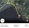
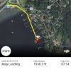
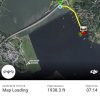
And so, I relocated my launch point down near the river in the parking lot of a popular restaurant, the Severn Inn. When I saw the funeral procession approaching the cemetery across the river I launched the Mavic 2 Pro and sought to find a good place to photograph from afar. It took me a couple of minutes to find the the initial shooting position, but finally did so and started taking photos. Shortly thereafter I re-positioned the drone for a better shooting position. Around 6 minutes into the flight I noticed that I was having problems controlling the aircraft. Based upon the video feed, it was NOT responding to lateral movements that would show up on the iPad screen. Then the video link was lost for some seconds, before being restored, then lost again. The last thing I saw on the iPad was the drone apparently sitting in dense bushes. Unfortunately I was not able to get a screen shot, but I know for a fact that it did NOT land in the water. The flight logs and records end at 7minutes and 14 seconds, with the drone positioned 10 yards or so off shore.
I have no idea if the aircraft landed at 7:14, or if it landed on its own after that. But I do know that I saw the image of it sitting in dense foliage. It definitely did NOT land in the water. With the cooperation of local residents I searched for several days to find the aircraft, to no avail. I even took my Mavic Air there on several occasions to see if I could locate the lost aircraft from the air.
The rest of the story is that I did NOT yet have insurance for my two aircraft, though I DID have DJI Care Refresh for both. BUT, with DJI Care Refresh you must return the aircraft, even in pieces, to get coverage. Lost aircraft equals lost coverage, unless there was some aircraft failure. I wrangled with DJI for a week as to whether something went wrong, but all they could come up with was that, "
The aircraft worked in GPS mode, and responded to the pilot’s control well; At t=07:15, h=69 m, d=507 m, the record ended when the aircraft was hovering." That was an expensive ($874) lesson that I will try not to repeat.
I am attaching the Flight Record for my 3rd and fatal flight that day, plus some screenshots captured from DJI GO4 replaying the flight. I know that the Flight Log was SYNC'D to DJI, but then deleted from the iPad. I'm presently at a loss as to how to recover the Flight Log (.DAT file) from my account at DJI to share with you. Any ideas there? Also, if there is anything else that might be helpful, just let me know. Thanks in advance for any insights you might be able to provide.
Best Regards,
Bill Taylor
301-346-7202
[email protected]
Gambrills, MD
First off, thanks to everyone who contributed to my recent thread "Mavic 2 Pro Crash Dive." It should be repaired by next week; meanwhile I'm waiting for word from the insurance company regarding coverage for the loss.
My positive experience (valuable responses) with the above post leads me to go back in time to get some assistance (possibly) in understanding what went wrong with my brand spanking new Mavic 2 Pro back in September 2018. I received the Mavic 2 Pro on August 27th and flew it locally for a few days. The big event for that Labor Day Weekend was the funeral and burial of Senator John McCain at the Naval Academy on Sunday, September 2nd, 2018.
So, I positioned myself in a perfect (so I thought) location across the Severn River from the Naval Academy Cemetery at the "Governor Ritchie Scenic Overlook" that is immediately adjacent to the Maryland World War II Memorial. This location sits a hundred feet or so above the Severn River and offers a spectacular vista of the Naval Academy and Annapolis across the river. The problem was there was no hard schedule for the actual burial of Senator McCain. The Funeral Service at the Naval Academy Chapel was set for 2pm, and that dragged on forever with no signs of ending.
It is noteworthy that the Naval Academy property is a Restricted Flight Area where you are not supposed to fly. I had checked this out carefully, and knew that I SHOULD be able to fly right up to the seawall near the cemetery and shoot from there at 2-300ft up. I used up two of my three batteries guessing wrong about the timing. And so, I waited at the overlook with my third battery reserved for when the funeral party with the casket finally appeared across the river.
While I was waiting, with about a dozen or more other interested folks with their binoculars and cameras, two black-clad and armed DoD police officers appeared asking who was flying the drone? I immediately fessed up; showed them the drone, my FAA Registration Card, and my FAA Remote Pilot Certificate. I mentioned that I was intentionally flying in non-restricted space. They didn't argue that point, but DID make the point that they had been asked by the powers that be to find the drone pilot and ask them to cease and desist flying so close to the cemetery, open air space or not. I didn't argue with them, but did ask if it was acceptable for me to fly the drone from the other side of the river? They agreed that was probably OK so long as I stayed close to the shoreline across the Severn River.
And so, I relocated my launch point down near the river in the parking lot of a popular restaurant, the Severn Inn. When I saw the funeral procession approaching the cemetery across the river I launched the Mavic 2 Pro and sought to find a good place to photograph from afar. It took me a couple of minutes to find the the initial shooting position, but finally did so and started taking photos. Shortly thereafter I re-positioned the drone for a better shooting position. Around 6 minutes into the flight I noticed that I was having problems controlling the aircraft. Based upon the video feed, it was NOT responding to lateral movements that would show up on the iPad screen. Then the video link was lost for some seconds, before being restored, then lost again. The last thing I saw on the iPad was the drone apparently sitting in dense bushes. Unfortunately I was not able to get a screen shot, but I know for a fact that it did NOT land in the water. The flight logs and records end at 7minutes and 14 seconds, with the drone positioned 10 yards or so off shore.
I have no idea if the aircraft landed at 7:14, or if it landed on its own after that. But I do know that I saw the image of it sitting in dense foliage. It definitely did NOT land in the water. With the cooperation of local residents I searched for several days to find the aircraft, to no avail. I even took my Mavic Air there on several occasions to see if I could locate the lost aircraft from the air.
The rest of the story is that I did NOT yet have insurance for my two aircraft, though I DID have DJI Care Refresh for both. BUT, with DJI Care Refresh you must return the aircraft, even in pieces, to get coverage. Lost aircraft equals lost coverage, unless there was some aircraft failure. I wrangled with DJI for a week as to whether something went wrong, but all they could come up with was that, "
The aircraft worked in GPS mode, and responded to the pilot’s control well; At t=07:15, h=69 m, d=507 m, the record ended when the aircraft was hovering." That was an expensive ($874) lesson that I will try not to repeat.
I am attaching the Flight Record for my 3rd and fatal flight that day, plus some screenshots captured from DJI GO4 replaying the flight. I know that the Flight Log was SYNC'D to DJI, but then deleted from the iPad. I'm presently at a loss as to how to recover the Flight Log (.DAT file) from my account at DJI to share with you. Any ideas there? Also, if there is anything else that might be helpful, just let me know. Thanks in advance for any insights you might be able to provide.
Best Regards,
Bill Taylor
301-346-7202
[email protected]
Gambrills, MD