

Has anyone ever had a drone disconnect mid flight back on rth? I was taking a still shot when the rth activated due to being at 20% battery. I know better than to touch the controls because the image on my controller froze. I tried to hit the cancel button because it was hovering over a safe place. However the screen went black and white then returned to the main Dji screen and said was disconnected. In the mean time I was looking in the sky for the drone and couldn’t find it. The flight log says after it went in to rth it flew straight up to 300 feet (well above any trees in the area) then started coming back. But then lost signal. It was flying at 20 mph and then seems to have slowed down instantly and then lost connection. Bird? I can’t find the drone anywhere. I have used my other from to look in the trees and surrounding areas and have spent days searching. Any thoughts?
You are using an out of date browser. It may not display this or other websites correctly.
You should upgrade or use an alternative browser.
You should upgrade or use an alternative browser.
Drone disappeared on rth route
- Thread starter gnp-droneflyer
- Start date
Yorkshire_Pud
Well-Known Member
Hello from the Crossroads of America gnp-droneflyer.
As mentioned above, post the flight log.
Follow the instructions from this link on how to retrieve the flight log from your device.
 www.phantomhelp.com
Copy / paste a link back to here if you want a member to view it.
We have members that can decipher information about the flight if you post the log link and possibly locate your aircraft in a particular area.
Good luck and welcome to the Forum.
As mentioned above, post the flight log.
Follow the instructions from this link on how to retrieve the flight log from your device.
DJI Flight Log Viewer | Phantom Help
Upload and view flight logs from your DJI drones
www.phantomhelp.com
Copy / paste a link back to here if you want a member to view it.
We have members that can decipher information about the flight if you post the log link and possibly locate your aircraft in a particular area.
Good luck and welcome to the Forum.
Log uploaded to Photos help Not sure how to post the log file. Ah figured it out lolPost the log.
MA2 317" data-source="post: 1579527" class="bbCodeBlock bbCodeBlock--expandable bbCodeBlock--quote js-expandWatch">Hello from the Crossroads of America gnp-droneflyer.
As mentioned above, post the flight log.
Follow the instructions from this link on how to retrieve the flight log from your device.
DJI Flight Log Viewer | Phantom Help
Upload and view flight logs from your DJI drones
Copy / paste a link back to here if you want a member to view it.
We have members that can decipher information about the flight if you post the log link and possibly locate your aircraft in a particular area.
Good luck and welcome to the Forum.
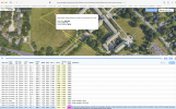
Thanks not really good with these forum things yet but this is where the last coordinate said it was... I flew my old drone for 40 min looking and the other day put on thick clothes and scoured the bee infested area too. as soon as I lost the signal i walked toward where it last was and looked for it but didn't see it at all. Of course I'm an idiot and started it under a different tree because it was 98* that day. but I had someone with me and they stayed there to see if they saw it come back and they didn't. The app crashed shortly after the rth started and I don't know if that caused the disconnection or if the aircraft hit a bird or something. but it basically vanished... I checked the ground under those trees and the whole surrounding area a dozen times over 3 days... According to the log it flew up way higher than the trees before I lost the signal.
Last edited:
A few points, 300 feet is a pretty high RTH altitude setting and might have a caused significant battery drain during the climb (not what you want in a low battery RTH scenario). 100 feet is usually plenty to clear any trees. What did you have your loss of signal action set to? Hover, land, or RTH? If it climbed to 300 feet it's odd that you lost signal unless you were quite far away. Without the log it's all speculation.
Agree Im going to set it a bit lower... The trees around here can clear 150ft easy but I'd think 200 ft is plenty...A few points, 300 feet is a pretty high RTH altitude setting and might have a caused significant battery drain during the climb (not what you want in a low battery RTH scenario). 100 feet is usually plenty to clear any trees. What did you have your loss of signal action set to? Hover, land, or RTH? If it climbed to 300 feet it's odd that you lost signal unless you were quite far away. Without the log it's all speculation.
The battery was at 20% when it auto went in to RTH. according to the log i had great signal all the way through. When it went in to rth I tried to cancel it because I could have just landed where I was safely but when I hit cancel nothing happened and the screen on my dji remote (the new one with the screen) froze on the last picture I took. THat's when I started running towards the aircraft to see what it was doing... but never saw it. Maybe it got too high IDK. But the flight log said it was still at 17% and strong signal when it vanished. RTH action was set to return to home point. I had someone watching for it at the home point too.
mobilehomer
Well-Known Member
"I tried to hit the cancel button because it was hovering over a safe place." This might be your problem. The log stops when you have a disconnect. It probably tried to land right where the log says. But at 300' altitude, whatever wind there was probably affected the descent.
The flight log says it was heading back 17% battery full signal then oddly switched to sport mode then back to RTH then gone... I can only suspect a hawk or goose or something hit it and dislodged the battery enough to turn it off? And if so it should have fallen pretty close to that area which I searched for hours on foot and with my other drone...
Unless a real off chance a hawk grabbed it and took off with it IDK! I wish the receiver had shown me what was happening but it froze shortly after the RTH notification popped up and that was the last thing I saw
Unless a real off chance a hawk grabbed it and took off with it IDK! I wish the receiver had shown me what was happening but it froze shortly after the RTH notification popped up and that was the last thing I saw
Attachments
Wasn't windy at all... And wouldn't the log say that? I hit the cancel button right after it activated and it flew 300' up and 100+ feet towards the home point before it lost signal... I've canceled RTH plenty of times and just fly it home manually Idt I've ever had it RTH all the way in 8 years of using drones... I'm no expert but I'm have a bit of exp with them... Prob about 15-20 hrs of flight time."I tried to hit the cancel button because it was hovering over a safe place." This might be your problem. The log stops when you have a disconnect. It probably tried to land right where the log says. But at 300' altitude, whatever wind there was probably affected the descent.
This has definitely been a learning exp for sure... One thing I'd like to get is some sort of tracker that can beep separate from the drone itself... Any suggestions? Maybe like an apple tag or something? Also never ever send a drone back in the air without swapping to a new card! I lost 2 hrs of footage for that one last shot! Could kick myself in the face...
That's just where the drone was when signal was lost.but this is where the last coordinate said it was...
There's no reason to assume that's where the drone ended up.
You had the drone set to RTH on loss of signal, so that's what should have happened when signal was lost.
There's nothing in the data to indicate that it hit anything and it had plenty of battery to make the 600 ft distance to home.
It appears to have braked and come to a stop at 20:19.1 while the RTH was active.
This is usually a false alarm caused by Obstacle Avoidance reacting to a low, bright sun.
Around the homepoint is the obvious point to search first because that's where the drone was programmed to go on loss of signal.Of course I'm an idiot and started it under a different tree because it was 98* that day. but I had someone with me and they stayed there to see if they saw it come back and they didn't.
As it's a big leafy tree the drone could be caught up in the canopy and you'd never know and it could be near impossible to see.
Failing that, anywhere along the line between the last point of contact and the home point should be looked at.
mobilehomer
Well-Known Member
Don't forget "I tried to hit the cancel button because it was hovering over a safe place." This was right before he lost signal.That's just where the drone was when signal was lost.
There's no reason to assume that's where the drone ended up.
You had the drone set to RTH on loss of signal, so that's what should have happened when signal was lost.
There's nothing in the data to indicate that it hit anything and it had plenty of battery to make the 600 ft distance to home.
It appears to have braked and come to a stop at 20:19.1 while the RTH was active.
This is usually a false alarm caused by Obstacle Avoidance reacting to a low, bright sun.
Around the homepoint is the obvious point to search first because that's where the drone was programmed to go on loss of signal.
As it's a big leafy tree the drone could be caught up in the canopy and you'd never know and it could be near impossible to see.
Failing that, anywhere along the line between the last point of contact and the home point should be looked at.
Yorkshire_Pud
Well-Known Member
@Meta4 has addressed a question that was puzzling me, why did the drone slow down during the RTH? I.e. OA.
Was the RTH into the sun?
The thing I am left wondering is, at 326ft what battery percentage would the low battery forced landing kick in? That probably depends on the the intended descent rate.
I don't know what that percentage is but at close to 16% charge I suspect it was close.
The question becomes, if the threshold was reached during the set failsafe behaviour of RTH would the drone cease the failsafe behaviour and start landing?
I do not know but bear in mind that part of the failsafe RTH behaviour is, at that distance, a 50m flight BACK along the 'in bound' flight path. That, if completed, would have put the drone over the point where the original climb to RTH height began.
Last edited:
Best guess is the drone ran out of battery After flying up to 300’. Dad to lose a drone like that.
It didn't.Best guess is the drone ran out of battery After flying up to 300’
The drone climbed to RTH height (326 ft) and made it to within 600 feet of the home point and still had 17% battery - more than enough to get home easily.
It's possible but looking at the telemetry data reveals something odd going on with the roll axis....It appears to have braked and come to a stop at 20:19.1 while the RTH was active.
This is usually a false alarm caused by Obstacle Avoidance reacting to a low, bright sun.
At 1219,3 sec into the log (this was the last flight of several on the same power on)... when the craft already have ascended up to RTH height & reached it's max heading speed towards the HP it suddenly appear to brake as the pitch goes from -28,5 degrees to +31,4 degrees. This could support a braking scenario, especially if the OP confirms that the return path to HP was into the sun... but in the middle of the "braking" the craft also rolls heavily to the left, from a roll angle of +1,6 degrees just before the craft pitches up to -18,4 degrees & then returns equal quick to approx. -1 degree.
Also the yaw axis is affected in some degree. This could indicate something else than a ordinary braking.

@gnp-droneflyer In the end the craft could have ended up in 3 different locations...
1. The craft was unharmed & could return to HP... the craft is somewhere in the tree tops there & well hidden.
2. The craft was harmed in some way right there when it pitches & rolls over... the craft is in the tree tops near the last known GPS position.
3. The pitching up was really a braking due to flying into the sun... the craft maybe could make stepwise slow progress towards the HP from where the log ends. In this case the battery most probably drained down until the low battery voltage forced auto landing started... the craft is then somewhere along a straight line between the last known position in the log & the HP, maybe in another tree top or on the roof of that house it had to fly over on the way to the HP.
Similar threads
- Replies
- 7
- Views
- 687
- Replies
- 21
- Views
- 2K
- Replies
- 5
- Views
- 425
- Replies
- 4
- Views
- 662


DJI Drone Deals
1. Mini 2
2. Mini 3 Pro
3. Mini 4 Pro
4. Air 2s
5. Air 3
6. Avata 2
7. Mavic 3 Pro
8. Mavic 3 Classic
2. Mini 3 Pro
3. Mini 4 Pro
4. Air 2s
5. Air 3
6. Avata 2
7. Mavic 3 Pro
8. Mavic 3 Classic
New Threads
-
 Dji mini SE gimbal suddenly works, then doesn't
- Started by flyingwithkris
- Replies: 0
-
-
 Mini 2 St Anne's church in Cork City, Ireland
- Started by FlyingDutchman90
- Replies: 0
-
-
Members online
- notupus
- wsteele
- Parkerjh
- YVRGUY
- DougMcC
- BingBong
- x-uas
- Ty Pilot
- DashSolo
- wmjbergin
- ClearedHot
- Petegoud
- RobertH
- kenstar2
- Gnuwave
- geo4570
- andybatz
- Willyb97
- Canesfam
- ScottGK
- zi0m3k
- aj4g
- Ancient Aviator
- orionshooter
- Gozar
- PetitFrereArmada
- buckeye742
- BOREAS
- smb8129
- Galopin
- mavic_minis_fly_away
- Malcx
- Kiwicbrthou
- kenwilliams
- halvoric
- tribar
- Drifter70
- Glock
- bcfd29
- roby17269
- Jarrodwp1
- PakNheat380
- MavicAir2Marc
- AlwaysAWOL
- TinajaEco
- dmathis
- usbethjim
- PanoVolo
- howardK
- Aerialskape
Total: 1,177 (members: 53, guests: 1,124)
Forum statistics
