DJI Mavic, Air and Mini Drones
Friendly, Helpful & Knowledgeable Community
Join Us Now

Is there a control app that can show a user-selected telemetry parameter in real-time?

crada

Active Member
Joined
Mar 1, 2023
Messages
31
Reactions
14
Age
44
Location
Squamish, Canada
After a flight, we all know that the flight log stores a huge amount of information. However, only a small fraction of it is available in real-time as we fly. In some cases, it would be very useful for my work to be able to see some of the telemetry data in real-time. The examples that are more relevant to me are:

1.- See pitch and/or roll to know in what direction the wind is blowing (a high winds warning with winds blowing towards the sea is more serious than towards land).
2.- See the GPS altitude. It is known that the altitude reported and used by the drone for navigation is a mix of GPS and barometric measurements, and sometimes, it can be tens or even a hundred meters off the real altitude. Especially if you take off with a poor GPS signal. So, seeing the GPS-only altitude would be useful (as once you are several hundred meters high, the GPS signal is usually very good).

Then my question is: Is there any control app that allows choosing one of these (or any) telemetry parameter to be shown in real-time on the flight control screen?
 
If you are talking about a fly app using drone then
1) via the 'artificial horizon' in the Fly app
2) the height displayed in the app is barometer ONLY based, it does not display GPS height. As far as I know GPS height is regarded as inaccurate. Even if it did display GPS height and GPS height was/is accurate it would be of as much use to you as the current system based on height relative to the take off point.
For anything else, the equipment would need to carry a 3d 'map'/database and compare location data for the takeoff point and current location.
 
Last edited:
As far as I know GPS height is regarded as inaccurate
I don't know if that's well known, but I can confirm from my experience in researching data sources to use for my flight log readers. Some are more accurate than others -- and then the accuracy can change by source for different locations across the world. It's quite the mess.


See pitch and/or roll
You can use the attitude indicator in DJI Fly. Lots of videos on YouTube cover it -- this one for example:

 
  • Like
Reactions: crada
If you are talking about a fly app using drone then
1) via the artificial horizon in the app in the
2) the height displayed in the app is barometer ONLY based
Thanks for the insight.
I use DJI Fly and Go4 and I didn't know they have an artificial horizon. I just read about it, and it is indeed a great feature. Thanks for pointing that out.

Regarding the height, thanks for the clarification. But I know the app does receive the GPS height (because it ends up in the log). So my question is if there is a control app capable of showing that information in real-time.
 
I know the app does receive the GPS height (because it ends up in the log)
Are you referring to the elevation at the takeoff point? The flight log doesn't record the elevation after that point.
 
As far as I know GPS height is regarded as inaccurate.
In that subject, I know more, and that is not true. The GPS height has noise (it can jump up and down a few or up to tens of meters), making it terrible for calculating climb rates, but it has great absolute accuracy. That means that those jumps up and down are around the true elevation.
The barometer is very stable (low noise) but has terrible absolute accuracy. Everyone who ever had an altimeter watch knows that, as sometimes, by looking at the barometric altitude, a place can be at 100 m one day and 200 m the next.

Then, for relative elevations over short periods of time (like a drone flight), the barometric altitude is very good. However, the rate of change of pressure with altitude depends on temperature and other variables, and DJI has done a terrible job of compensating for those factors. And if you get an unlock certificate and fly above the 500 m over take-off, the difference between GPS elevation and barometric can become huge (over 300 m). At that point, the GPS height is much more accurate than the barometric height.
 
Are you referring to the elevation at the takeoff point? The flight log doesn't record the elevation after that point.
The log contains the GPS coordinates (latitude, longitude and elevation above sea level) throughout the whole flight. In the DAT file, those fields are GPS:Long, GPS:Lat, GPS:heightMSL. These are different from the one calculated by the IMU using the barometric pressure like the fields: IMU_ATTI(0):Longitude, IMU_ATTI(0):Latitude, IMU_ATTI(0): Press: D, IMU_ATTI(0):alti: D IMU_ATTI(0):relativeHeight:C, IMU_ATTI(0):absoluteHeight:C.
 
The log contains the GPS coordinates (latitude, longitude and elevation above sea level) throughout the whole flight
To clarify, I was referring to the TXT flight log located on the mobile device where DJI Fly is installed. While that data might be available on the aircraft, I'm not sure if it's sent down to the remote controller.
 
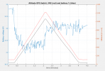
To illustrate the idea. This plot shows the flight data of a Mavic Pro flying straight up that reached 1220 m above sea level according to the IMU but only 1058 m according to the GPS. That is a difference of 162 m, much more than the GPS error. The difference at take-off is 74 m; therefore, there is 88 m drift of the IMU through the flight.
In this case, the Go4 app showed a maximum elevation of 1112 m above take off, but according to the GPS it was only 1024 m above take off. There again is that 88 m difference, which is a significant amount if you planned to take a measurement (or a picture) at a planned elevation.
I use these flights to measure vertical temperature profiles; that's why I care about the real absolute height above sea level.
gps.png
 
  • Like
Reactions: WanderLost
The log contains the GPS coordinates (latitude, longitude and elevation above sea level) throughout the whole flight. In the DAT file, those fields are GPS:Long, GPS:Lat, GPS:heightMSL.
i-SR6Fh75-L.jpg
How are you going to use DJI's"GPS Height" ?
 
  • Like
Reactions: DougMcC
I use these flights to measure vertical temperature profiles; that's why I care about the real absolute height above sea level
I don't think accessing that data is going to be possible with a DJI consumer drone.
 
To clarify, I was referring to the TXT flight log located on the mobile device where DJI Fly is installed. While that data might be available on the aircraft, I'm not sure if it's sent down to the remote controller.
It is definitely sent to the remote controller, because for my post-flight analysis I get the data from the phone (.dat file stored in the Go4 folder, which can be decoded with CsvView), and it is all there. I just wonder if there is any app that allows to see all that data as it gets transmitted in real-time.
 
I use these flights to measure vertical temperature profiles; that's why I care about the real absolute height above sea level.
If you want actual heights above sea level, I think you'd be best adding the relative height as shown on your screen or flight data to the known elevation of your launch point.
I'm pretty sure that what you've assumed to be GPS height, isn't.

Try some testing and fly from the same point during high and low air pressure weather and see how things compare.
I think you'll find that the ambient air pressure makes a huge difference to what DJI might call "GPS height".
You won't even need to launch the drone to do this.
 
I just wonder if there is any app that allows to see all that data as it gets transmitted in real-time
No such app exists. Could someone create an app like that? Seems reasonable since the DAT file is not encrypted.
 
The imu altitude is not from sea level. O is from the altitude of the takeoff point when the drone powers up and initializes the barometric altimeter. You need to add the above sea level height to it to get the true above sea level altitude.
 
I don't think accessing that data is going to be possible with a DJI consumer drone.
Why not? That data is accessible using DJI SDK. Apps like Litchi include that info in the flight logs. It would be up to the app developer to show that information in real-time.
 
The imu altitude is not from sea level. O is from the altitude of the takeoff point when the drone powers up and initializes the barometric altimeter. You need to add the above sea level height to it to get the true above sea level altitu
The IMU also computes absolute altitude (above sea level). In the DAT flight log it is stored in the field "IMU_ATTI(0):absoluteHeight"
 
What's the name of that column in Litchi flight logs?
I'm sorry, my mistake. Litchi doesn't seem to log that. But Go4 does.
The point is that Litchi and other apps log a bunch of data that is not shown in real-time. An example of that for Litchi could be current draw from the battery. And my question was just about that: Is there any control app that allows choosing one of these (or any) telemetry parameter to be shown in real-time on the flight control screen?
 
Lycus Tech Mavic Air 3 Case

DJI Drone Deals

New Threads

Forum statistics

Threads
131,133
Messages
1,560,160
Members
160,105
Latest member
anton13