

If it's too hard to get the flight data, can you describe your launch site?I'm working on it, but my Mac is also dying so I can't hook up to itunes

You are using an out of date browser. It may not display this or other websites correctly.
You should upgrade or use an alternative browser.
You should upgrade or use an alternative browser.
Mavic went ROGUE, and is gone
- Thread starter ac30
- Start date
If it's too hard to get the flight data, can you describe your launch site?
Launched from a trail in the woods, Over a railway bridge, where the forest meets the waterfront in bates park
Crashed at the yellow highway bridge.
Attachments
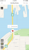
Launched from a bridge?Launched from a trail in the woods, Over a railway bridge, where the forest meets the waterfront in bates park
Crashed at the yellow highway bridge.
A bridge with a lot of steel in it?
Top Hat
Well-Known Member
- Joined
- Mar 5, 2017
- Messages
- 1,545
- Reactions
- 733
"DJI Care Refresh", you need the AC body for them to replace it.
In cases that your flight data revealed a malfunctions w/ the HW or FW then you might have a chance of getting a Refurbished AC or a 30% Discount.
I maybe wrong.
In cases that your flight data revealed a malfunctions w/ the HW or FW then you might have a chance of getting a Refurbished AC or a 30% Discount.
I maybe wrong.
Danny Panini
Active Member
- Joined
- Nov 7, 2018
- Messages
- 33
- Reactions
- 4
- Age
- 34
Malfunction is completely their fault. Full refund it shall be. Have you tried?

Only two problems with that.Malfunction is completely their fault. Full refund it shall be. Have you tried?
How do you know the problem was a DJI issue?
If he can't return the drone to DJI for their investigation, how will they know what the cause of the incident was?
I agree, I haven't read anything to this point that shows a definitive malfunction of any kind. That's a big leap on evidence up to now and one I would bet DJI won't agree with.Only two problems with that.
How do you know the problem was a DJI issue?
If he can't return the drone to DJI for their investigation, how will they know what the cause of the incident was?
No the trail is up on the hillside, the bridge is at the shoreline. I was panning away from the bridge before the drone took offLaunched from a bridge?
A bridge with a lot of steel in it?
What I said back in post #12 still goesNo the trail is up on the hillside, the bridge is at the shoreline. I was panning away from the bridge before the drone took off
You will have to post flight data or people can only guess.
Without data, there's not much point to this thread.
InvisibleName
Well-Known Member
What possible evidence do you have to make this bold statement??Malfunction is completely their fault. Full refund it shall be. Have you tried?
Looks like compass was initialised wrong because of interference.
This is not true you did give some aileron (and rudder) inputs right after GPS lock (@~50 sec). Then at the last moment you give full elevator as you described. But because of the misaligned compass the drone reacted wrong. After the IMU heading exception the drone is basically out of control.

The way to prevent this is to make sure the arrow on the phone screen is pointing the same way as the drone itself during takeoff. If they are not pointing in the same way it means the compass is wrong (likely because of local interference). moving a few meter and trying again usually solves this and avoids this kind of loss of control.
DJI will probably offer a discount, but they generally do not call this a malfunction that warrants a free replacement.
- For the first 48.5 seconds you had no GPS lock and were in ATTI mode.
- In ATTI mode the misaligned compass is not an issue.
- As soon as you got GPS lock this misalignment became a problem.
- A few seconds after the GPS lock the IMU encounters the heading exception (due to misaligned compass).
- Because the drone did not switch back to ATTI this resulted in the "toilet-bowl spiral of death". (uncontrolled flight until the inevitable crash)
Reviewing the flight record and video feed, you can see i'm not touching the joysticks after initial take off... for 10 seconds until the very last second in an attempt to avoid the crash.
This is not true you did give some aileron (and rudder) inputs right after GPS lock (@~50 sec). Then at the last moment you give full elevator as you described. But because of the misaligned compass the drone reacted wrong. After the IMU heading exception the drone is basically out of control.
The way to prevent this is to make sure the arrow on the phone screen is pointing the same way as the drone itself during takeoff. If they are not pointing in the same way it means the compass is wrong (likely because of local interference). moving a few meter and trying again usually solves this and avoids this kind of loss of control.
DJI will probably offer a discount, but they generally do not call this a malfunction that warrants a free replacement.
I certainly didn't launch from the double railway tracks. The tracks with the railcars are down below at the shoreline running east-west
I was filming a train coming across the bridge north -south. I was up above (hillside) closer to the gravel lot, in the trees. That's where the trail is.. (Above the yellow trees in image 2)
And yes I did pan slowly to the left initially to capture the side shot of the train on the green bridge... It was acting normal for that brief moment.
Even though the compass would be off, I can understand that having an affect on the drone turning the wrong way maybe, but I was operating it successfully to start and then it just took off without any controller input...
Also FYI my joysticks aren't default, left stick is elevation and sideways banking.
Right stick is forward/back and yaw (turn)
First and last image included
Attachments


Last edited:
yes, you are right. the double tracks is just where you got the GPS fix, it's not the takeoff point, my bad.I certainly didn't launch from the double railway tracks. The tracks with the railcars are down below at the shoreline running east-west
As long as you did not have GPS lock, the compass issue does not matter because the drone is not using it.Even though the compass would be off, I can understand that having an affect on the drone turning the wrong way maybe, but I was operating it successfully to start and then it just took off without any controller input...
As soon as you get GPS lock at 48.5 sec into the flight, the drone will start using the compass and then it takes off uncontrollable.
There are quite a few similar reports with the same behaviour. Feel free to wait for @sar104 . He is the expert on this.
Also FYI my joysticks aren't default, left stick is elevation and sideways banking.
Right stick is forward/back and yaw (turn)
First and last image included
that does not really matter for the issue and the result.
Lonjsnyder
Active Member
- Joined
- Oct 19, 2016
- Messages
- 34
- Reactions
- 22
- Age
- 61
Are compass issues common? Because I wasn't prompted to calibrate on this flight, but my previous launch --in a forest with no interference-- it wouldn't calibrate
When DJI came out with the Mavic and eliminated the ability to manually switch to ATTI mode (which the Phantom 4 line has), it made getting a good startup up compass initialization that much more important. Crashing from starting up your aircraft and taking off from an unseen source of magnetic interference seems to be a very common occurrence within many threads on the forum.
In my experience, however, magnetic field extend for only a few feet.
There are many free smartphone “metal detection apps”. Whenever I fly from a new location, I always test the take-off surroundings for magnetic interference. You can fly near the magnetic fields as long as you’re far enough away from their relatively limited range.
Metal Detector iOS App:
Metal Detector (PRO)
Example of flying near magnetic fields:
As for checking if AC position in radar matches actual, note that often Mobiles need compass calibrations. I have yet to see a mobile that doesn't need one each time you use it.
However if you know where north really is, AC direction relative to actual north should match radar AC position relative to radar's north.
However if you know where north really is, AC direction relative to actual north should match radar AC position relative to radar's north.
BobsMavicAir
New Member
- Joined
- Oct 16, 2018
- Messages
- 2
- Reactions
- 0
- Age
- 69
Similar threads
- Replies
- 5
- Views
- 646
- Replies
- 50
- Views
- 5K
- Replies
- 27
- Views
- 6K


DJI Drone Deals
1. Mini 2
2. Mini 3 Pro
3. Mini 4 Pro
4. Air 2s
5. Air 3
6. Avata 2
7. Mavic 3 Pro
8. Mavic 3 Classic
2. Mini 3 Pro
3. Mini 4 Pro
4. Air 2s
5. Air 3
6. Avata 2
7. Mavic 3 Pro
8. Mavic 3 Classic
Forum statistics
