I have set myself a personal challenge after watching so many Mini 2 videos.
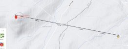
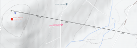
I wish to take off from a location at the top of a hill at 200 M above sea level ( The local heights restriction is 120 M - yet I know that this is set above the current ground level, so any flying objects will always be above 120 M from the highest ground point / not sea level. - not to mention that there will be no flying objects at point A. ) I am also not in any restricted or Yellow Zones when taking off, but Point B is in Yellow consideration Zone of local air port ( The authorisation zone (Blue Zone ) is still many KM away from anywhere I am flying. I need to be below 120M before approaching Point B however.
That being said, my questions is > If I take off from 200 M above sea level and set max height to something like 70 M which I know will clear any terrain between point A - B. Will the drone use its onboard sensors to drop down to this level as it descends down the hill and then remain at that level above ground level / Sea level until point B. Or do I need to compensate at take off > and ensure I manually drop down by 100 M from lift off point as i decent the hill, so it is still 100M above Sea level until point B.
The direct path from Point A to Point B is 4.7 KM so I don't expect to bring it home but instead land at point B ( My worry is that if the onboard sensors cannot compensate then my return to home altitude at any point will be below 200 M and go straight into the side of the hill.
I'm not an idiot however. I plan in testing this to death in increments at every point. I just need to know what the sensors are cable of.
Regards, Alan.
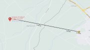