Hello dear friend, i have been a hobbist photographer with a mavic mini and now a
air 2s, i am doing some research on how to make ortophoto wth my drone to earn some money, what software do you use to create the actual ortho map after you capture all the pictures with pix4dcapture?
Those drones are not supported by Pix4Dcapture.
Photogrammetry software is very expensive. I’ve paid for DroneDeploy, OpenDroneMap, and Maps Made Easy. I use Pix4Dmapper, Cloud, Matic, and Survey professionally. I also dinked around with Metashape. These all will generate ortho mosaics and 3D models.
I directly compared data sets between Drone Deploy, Pix4DMapper, Cloud, Matic and Maps Made Easy. The Maps Made easy produced the worst ortho and a very simplified 3D mesh. DroneDeploy results are excellent, as are Pix4Dmapper and Matic. DD mesh models are better than Pix4Dcloud models, with better texture resolution and detail.
Prices are high though for both DD and Pix4D. ODM is free (or 50 bucks) and is decent, but has some drawbacks. I sometimes process jobs with over 2000 photos, and ODM is not efficient at that scale. My best laptop would also take 2 weeks to crunch all those bundle adjustments. That’s the other thing: do you have a high powered desktop available for processing hours/days at a time? If not, cloud processing services like DD and MapsMadeEasy are better deals, IMHO.
Maps Made Easy is inexpensive and what I currently use for small, non-survey grade maps and models for personal use. I like the pay-per-input credit system they use, since I may not make any maps for a couple of months. I use ODM for the same, but on my old PC so as not to interrupt anything else I work on. One other product I haven’t used is Reality Capture, which also uses a per-per-input system. I hear good things about RC.
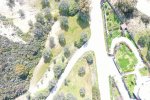
Sorry I went a little OT. I’d start a new thread and ask again, but TLDR: Beginner/hobbyist should look at ODM and Maps Made Easy for ortho photo processing.