What ferry are you referring to that you fly at on the Potomac? White's Ferry? That's all flatwater, so it's not the most interesting flying/filming.
My recommendation is to fly from the MD or VA side at
Violette's Lock (near Trump's Golf Course on the VA side). There's a stretch of rapids there with islands and trees in the middle of the river that extends about 3/4 mile downstream. Above Violette's Lock it's basically all flatwater up to Harper's Ferry and flatwater downstream of the rapids. The NFZ extends up to around Swain's Lock upstream from Great Falls NP. The MD side is obviously the C&O Canal NP, but if you walk down the C&O Canal about 1/2 mile until you get close to where it starts to bend, you'll come upon a stone wall. Take the little trail at the upstream end of the wall down to the rock islands that extend into the river. You'll have open sky to launch your drone from the rocks. In the attached photo, the launch area is to the top left. Accessibility from the VA side would require hiking quite a ways from wherever you park.
Harper's Ferry, WV is challenging due to the fact that the town, both sides of the Potomac and Shenandoah Rivers are National Park land. However, there are 3 areas where you can launch from legally and they all provide unique flying/filming opportunities.
#1 - in the water in either river (the rivers are not part of the NP). If you don't have your own canoe/kayak, there are several outfitters with a variety of watercraft. It's easy to park your kayak on a rock in the middle of the river to launch and have it follow you. I'd pick the Potomac section near Harper's Ferry Campground;
#2 - the rocky area accessible from the VA side of the Shenadoah/Potomac river junction opposite the town (also technically in the river) there's a wide shoulder parking area before you get to the traffic light/gas station, on google maps it's called Bass Rock
https://goo.gl/maps/GFaxujsC9KY2KN1N8;
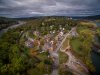
#3 - my favorite spot on the bluff that overlooks the town and the Potomac River where the abandoned hotel is. In my photo, it's visible near the horizon line right of center. The flagpole area has a couple benches and is a good high vantage point. There's often a security guard hanging out to keep people from going into the hotel ruins, but they won't bother you. To get there, go through the town on Washington Street, take a right on Columbia Street and another right on E. Ridge St.
★★★★★ · Vista point

goo.gl