Heres an interesting one for anybody using GSPro and Pix4D.
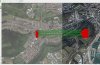
I ran a mission over this old fort, when trying to import into Pix4D it has interpreted some of the data several hundred metres to the west... even more strangely there are points from each of the two flights I did. Can anyone make sense of this?
PS images show I didn't randomly fly over to the other location!