DJI Mavic, Air and Mini Drones
Friendly, Helpful & Knowledgeable Community
Join Us Now

Where to see flight restrictions? DJI GEO or B4UFLY?

mavic14

Active Member
Joined
Mar 31, 2017
Messages
26
Reactions
0
Age
34
I'm curious what the right way to see local airport and how close they are. When I use B4Ufly it shows me so many that I don't even think exist near me. Meanwhile when I use this site DJI - The World Leader in Camera Drones/Quadcopters for Aerial Photography it shows only the one's I know of. Is it okay to just go by the DJI geosystem? Anyone else have other apps that may be helpful to legally know where to fly, it's confusing with the airports around me!

Thanks
 
Following this one. I noticed this as well. I open one app and it shows the 2 nearby airports. Then open a second app and it shows even more. Do I send letters or try to call of them before flying ? Which app is the "Go-To" app ?
 
I brought this up in PhantomPilots. I'll copy that post below (it's long). Basically, IMHO they are all crap, can't be relied on and are incorrect. That is just the bottom line. The FAA's B4UFly app is terribly lacking and focuses mainly on any possible airport that might exist. No one can rely on that app alone. For example it does not even contain jails and prison's, where it's illegal to fly. I think DJI has probably done the best job. They are less obligated to give out NFZ info, have done so already and it's really the most correct.

-------------------------------

I don't see that anyone has really offered any type of solutions to the issue of avoiding NFZ. DJI's info is of little help and certainly the FAA is (still) falling WAY short of what they should be doing.

Let me start with DJI. I think they have done a good job when weighted against what they should be responsible for. They have built in many NFZ to their software. However, this pretty much only includes large airports and prisons. I personally think they have done a very good job in giving only warnings when near these locations and only shutting down the drone when it's about a miles away from the center of the location.

Who I fault most is the FAA. The actual tax paid entity that is charge of NFZ. Do this... search right now online for a searchable map of NFZ in the US. I have never been able to find one from the FAA. Please feel free to post here is you know where the FAA has this online. What they have done is put out a smartphone app (B4UFly). They can include a searchable map in a cell phone but not online?

We know for a fact that we can't trust the FAA's review of the actual laws governing UAV use... we always need to go directly to those regulations. Go to the FAA's website and try to actually find the regulations explaining why you need to call the airport. It will probably take awhile to find this information.

https://www.faa.gov/uas/media/Sec_331_336_UAS.pdf

The main part that applies is Section 336. I'll paste part of this below:

upload_2017-3-20_11-35-19-png.78846


Now I could go on and on about the issues with the wording above but let me focus on one item... #5.

What is an "airport" as it applies to this entire section? It's not defined. You can find an explanation from the FAA in other areas of their website:

"An airport is defined in the law as any area of land or water used or intended for landing or takeoff of aircraft including appurtenant area used or intended for airport buildings, facilities, as well as rights of way together with the buildings and facilities."

So if the FAA chooses to follow their own information, you'd need to call anyone with anything that looks like could be used for a helicopter. So you'd need to include all helipads in the area. How many people call the local hospitals? If you do... PLEASE record that conversation as I'd love to hear their confusion.

Let me move in to the app....

If you look at the B4UFly app, it appears that the app almost agrees with this. That is, it seems to list most places that the FAA could know where aircraft can take off and land. This includes hospitals and small helipads. Other have commented on this (a fellow SLC flier recently)... if you were to go by the app, you may need to call a _lot_ of airports in order to fly in just one location. When I use a local zip code in the app, here is what was displayed:

screenshot_20170320-091845-png.78867


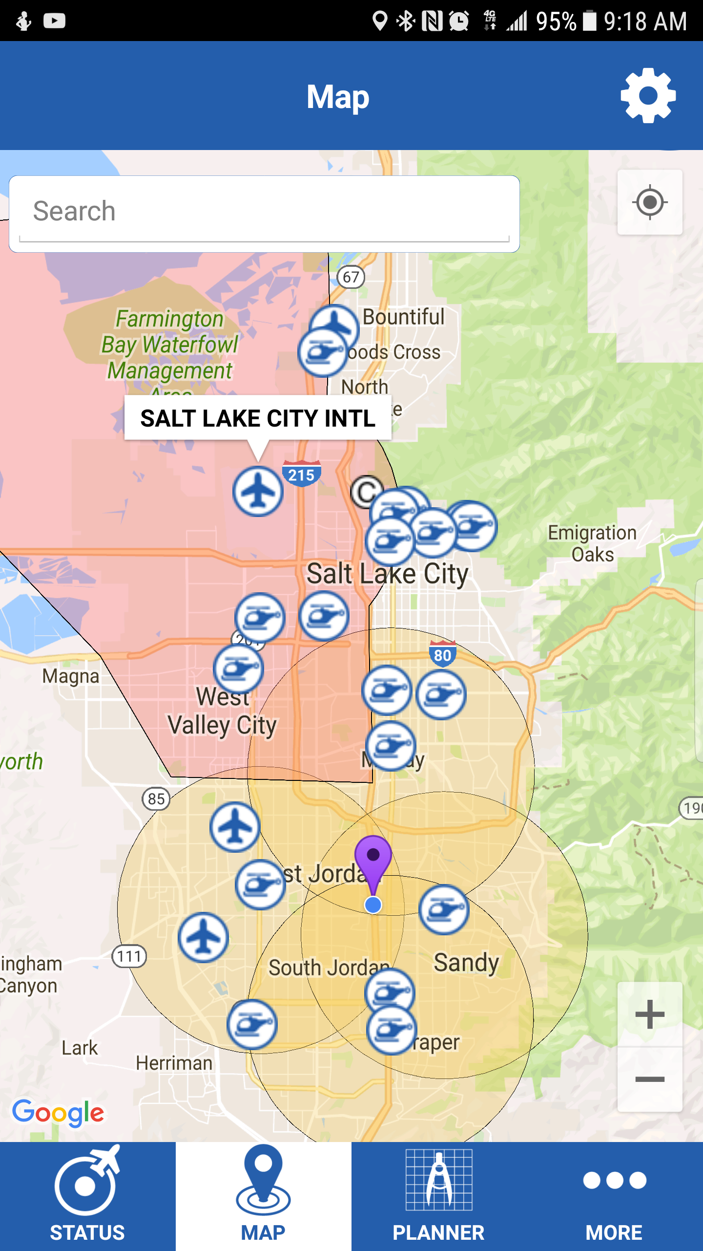
If I were to follow the map above, I've be calling 9 hospitals and some crazy small "airport" (it's called "Number 18" on the map) to obtain permission to launch a drone 1" off the ground. Seriously? How do I call "Number 18"? Then, what is that huge red area? It seems that Salt Lake International Airport is within hat area (though, the circle for the airport appears cut off in the north east corner) but there is nothing else showing to state what that large red areas is. I also did a search for Lehi, UT which contains a prison. We all know you cannot fly over a prison. Guess what.... nothing on the map for that!

So this is what the FAA gives us so that we can know where we can and cannot fly. This not only does not really help, it makes the situation worse in many cases. This really only scratches the surface of how badly
 
An interesting point when you speak of hospitals. Any open area can become a landing zone.

Being in law enforcement I've had to create landing zones for careflight to land. They dont always land at a crash scene. Landing zone can be a couple miles away due to heavy power lines, buildings, etc. Lifesquad would then meet there. Same would be for serious injury in a heavy wooded area or rocky area that prevented chopper from landing. It isnt always going to land at a hospital and transport from there.

Our choppers come from over 40 miles away at times.

I guess what my thought is that "someone" will eventually need to come up with a new system in the future as this hobby grows. I dont think a map will be sufficient with no fly zones. That may provide a general idea but still may not be accurate.

This would more likely fall under flying over an emergency scene.... but if the landing zone is created miles away from the crash at times... your flying zone may become a no flyzone without your knowledge.... far stretched but it can happen.
 
  • Like
Reactions: BigDaddyP
I use B4UFly app. DJI's flight zone info doesn't match FAA's app. I'll play it safe.
 
Im just going to send all the listed airports around me a blanket letter like the one I have seen posted on this site. And hope there are no future issues. I know there is an R/C Airstrip out in the desert behind my house. Guess I will be good to fly out there.
 
Use Airmap. So far it's the best one i've found and i've also heard a rumor that the Airmap system will be what FAA utilizes in the near future for digital notifications. B4UFLY is just bad and doesn't even provide contact phone numbers. I use Hover as well but mainly for the their opening page which shows the KP index. Not sure why but hover does not include a lot of airport/heliport information.
 
  • Like
Reactions: Norm
Im just going to send all the listed airports around me a blanket letter like the one I have seen posted on this site. And hope there are no future issues. I know there is an R/C Airstrip out in the desert behind my house. Guess I will be good to fly out there.
How could one just send all listed airports and start flying? Don't you need their permissions to fly? I bought a DJI Spark thinking I gonna have fun flying but after then I started to realize there are so many restrictions and now making flying no fun. This is a real bummer for all of us drone pilots.

Lastly for heliports, can't we just fly and when we hear a copter coming we just land our drone and give way to manned aircraft and of course we should not fly out of sight and above 400 AGL? Most of the places I wanted to fly are just surrounded by all this so called "hellports". I hardly see any copters flying and land from there. Maybe I just fly and see what is going to happen.
 
You just need to call airports if you are within the 5 mile limit.
Yes manned aircraft always have the right of way. Stay away from places where Emergency vehicles are responding to. If you hear an aircare chopper screaming into your area, get out of its way.
You can fly in most state parks. You can not fly in National parks or wildlife reserves.
If you want to fly in a local park or soccer field, call or write the county and ask if there are any laws prohibiting them. Most of the time they say no at least not until enough complain that they need a law.
Be discreet. Some people are paranoid and can cause a hassle. Show them the FAA list of rules and suggestions for hobby UAS flying.
Hi Arkarian,
Thanks for the reply. If I got you right, I don't really need to contact the heliport/s right? Not going to hold on to you for this but I know you guys have better knowledge than me. Like I said there are so many heliports like say 3 heliports around where I want to fly and having to contact each of them is a PITA. Lastly please help me determine will I have trouble flying at this location (32.292835, -110.959863)? I will like to take my son and have a good time. Of course I will avoid and stay away from crowded area but most time in the noon I hardly see anyone around. Thanks in advance. Greatly appreciate any input from you guys/gals.
 
You are not required to call the hospital helipad but ,given your location, I would not fly towards or over the helipad. You could call the hospital switchboard and let them know you are flying in the park.
Check the park website or county and ask if there are any current restrictions for that park. I live near Cincinnati and all Hamilton county parks are restricted by the county.
Thank you very much for sharing your knowledge. I will not fly over helipad, all I want to do was to fly around within the park perimeter and have some fun time with my son. Thanks for the heads up to find out if the park restrict drone flying. I had forgotten that bit. I assumed all parks are ok but I guess you are right. Have a great day. Really appreciate your input.
 
Hang in there. There are ok places to fly. I have several parks with no restrictions and two that are drone friendly as long as you fill out their form and send it in. Those last two just want proof you have ama membership and have registered your drone with the FAA.
 
  • Like
Reactions: sinaus
I'm curious what the right way to see local airport and how close they are. When I use B4Ufly it shows me so many that I don't even think exist near me. Meanwhile when I use this site DJI - The World Leader in Camera Drones/Quadcopters for Aerial Photography it shows only the one's I know of. Is it okay to just go by the DJI geosystem? Anyone else have other apps that may be helpful to legally know where to fly, it's confusing with the airports around me!

Thanks

The FAA's B4UFLY in the App Store has people wanting to give it less than one star.
 
Last edited:
Hover has the advantage of giving you the phone # to call, and in my area only shows the airports that I need to call. The Go 4 app then warns me when I'm near an unpaved runway, but that's not really a concern--just be careful and keep your ears open for approaching planes and choppers.
 
  • Like
Reactions: sinaus
Lycus Tech Mavic Air 3 Case

DJI Drone Deals

New Threads

Members online

Forum statistics

Threads
131,127
Messages
1,560,118
Members
160,099
Latest member
tflys78