DJ Wes's latest activity
-
 That makes sense of course!
 -
DJ Wes replied to the thread Where are waypoints stored?.You are not the first person to ask this question. I understand that for some people's workflow, off-line (stand-alone) versions might be preferred. So, I have thought about it but my preference is to provide these tools on-line. The on-line...
-
DJ Wes replied to the thread Inquiring into compatible mapping apps to use with DJI Mavic 2 Pro.Here are a few mapping mission creators that you can try: https://robertspark.github.io/grid-photogrammetry/ https://ancient.land/ https://afbayonac.github.io/grid-photogrammetry/
-
Thanks Dale. There is no video tutorial but it’s done mostly using Litchi Mission Hub and utilities found on this website Litchiutilites.com. All of the utilities found here are designed by Wes Barris, a well known drone enthusiast. Without his...
-
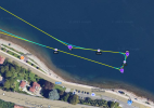
DJ Wes replied to the thread Waypoint Mission (IMPOSSIBLE) !!!!! 🇦🇮🦘.I prefer to have missions that will bring the drone back to me without any manual input from me. Here is how I would adjust your mission: When using DJI Fly, it would look like this (red path): Keep all of the waypoint heights the same...
-