Dogpilot's latest activity
-
 Dogpilot replied to the thread Mavic 4 Pro First Survey Use.The thermal drones can do visible light photos as well. You can set it up so it does both simultaneously. Wheil they have RTK positioning, they didn't include the precise time codes required to make it able to do precise maps. Kind of upsets many...
 -
Dogpilot replied to the thread Mavic 4 Pro First Survey Use.It has some impressive features for sure. I just do not need to track down miscreants. DJI's implementation of thermal software and options for the use of the thermal data is very limiting. For doing what you mentioned, it is great. Using it for...
-
Dogpilot replied to the thread Mavic 4 Pro First Survey Use.Of course a Matrice would be better. I sold off my enterprise drones, both the 3T and 3E. Problem is they can only do their one job, not much else. I would still need to strap the survey camera on it, since DJI's multispectral is pretty much an...
-
Dogpilot replied to the thread Most battery efficient distance mode.Real world this week, 9.5 km out and back, sport out normal back. Landed with 26% battery. This is clear arid country on a high point, not too terribly high, but a bit of a knoll. 10 knot wind, measured, flying at 6,200' (1890m) altitude. Trying...
-
-
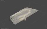
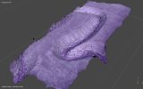
After a few false starts I finally got large waypoint grid surveys working on the Mavic 4 Pro. Litchi has a beta Hub that can output files you can put on the RC-2 Pro. Still Beta and it does have a few errors that crop up. The M4P is a bit tricky...
-