Felix le Chat's latest activity
-
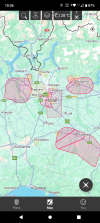
 Felix le Chat replied to the thread Is there anyone here who can help answer the most basic questions about flying a drone in Italy?.Italy abides by EASA regulation. The app you're looking for is Drone Assist by Altitude Angel. Zoom in tight to the region (in this case Milan) and you get the full range of accurate NFZ's: TFR's and warning areas.
 -
-
Felix le Chat reacted to Hoverfly2112's post in the thread Cover ban not allowed to fly in the New Forest in the UK and ability to enforce such a rule. with
 Like.
Here on the I.o.W the National Trust get shirty if your images taken on a DSLR of the land they own....let alone drones...and even of a bird, containing there land in the background (for instance, The Needles, Aluminium Bay or Tennyson Down)...
Like.
Here on the I.o.W the National Trust get shirty if your images taken on a DSLR of the land they own....let alone drones...and even of a bird, containing there land in the background (for instance, The Needles, Aluminium Bay or Tennyson Down)... -
Felix le Chat replied to the thread Insta360's AntiGravity A1 Takes Aim at DJI with 8K 360° Drone."...pilots can fly in one direction while looking in another..." Hmmmm... Someone in marketing had their mouth in gear before the brain was engaged.
-
Felix le Chat replied to the thread Photos not very sharp.Concur. Worked it through my usual RAW developer (not Adobe) and the fine detail is very good even at 200%. The only problem I spotted was some horrible moiré on the pumping tower roof tiles. Definitely not a camera I'd kick out of bed, but I...
-
I downloaded the DNG file, and opened it in Adobe Camera Raw, then transferred it to Photoshop and took a 100% crop there. What program did you use to get such a result? I seems to me you have opened the low-res preview file that is embedded in...