Felix le Chat's latest activity
-
 Felix le Chat reacted to Aerophile's post in the thread Is there anyone here who can help answer the most basic questions about flying a drone in Italy? with
 Like.
OMG!!!! I have Done Assist right here! Used it extensively in June when I was visiting the UK (see an example below). I'm all registered with EASA, drone labelled, both the drone and me are fully-compliant with all the regs - already. You're...
Like.
OMG!!!! I have Done Assist right here! Used it extensively in June when I was visiting the UK (see an example below). I'm all registered with EASA, drone labelled, both the drone and me are fully-compliant with all the regs - already. You're... -
Felix le Chat replied to the thread Software simular to Luminar Neo....also: Rawtherapee, Photoninja. Gimp is highly underrated but will handle anything Photoshop can be used for and you don't get Adobe's fingers in your wallet every month (it's freeware). Very advanced RAW developing and image manipulation...
-
Darktable or GIMP
-
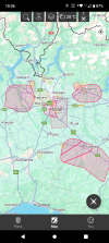
Felix le Chat replied to the thread Is there anyone here who can help answer the most basic questions about flying a drone in Italy?.Italy abides by EASA regulation. The app you're looking for is Drone Assist by Altitude Angel. Zoom in tight to the region (in this case Milan) and you get the full range of accurate NFZ's: TFR's and warning areas.
-
-
Felix le Chat reacted to Hoverfly2112's post in the thread Cover ban not allowed to fly in the New Forest in the UK and ability to enforce such a rule. with Like.
Here on the I.o.W the National Trust get shirty if your images taken on a DSLR of the land they own....let alone drones...and even of a bird, containing there land in the background (for instance, The Needles, Aluminium Bay or Tennyson Down)...