DJI Mavic, Air and Mini Drones
Friendly, Helpful & Knowledgeable Community
Join Us Now

Airspace confusion

VegasFlyer

Well-Known Member
Joined
Dec 12, 2019
Messages
47
Reactions
35
Age
64
Location
Nevada
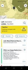
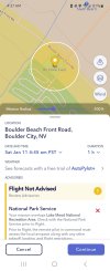
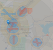
Attached are four screenshots from four different sources regarding the same location. A FRIA (RC Plane Field) is located near Lake Mead in Nevada, not far from Hoover Dam. (Flying near the dam is strictly prohibited.) Notice the color of the airspace around the FRIA. The screenshots from AutoPylot and Air Aware are pretty much in agreement that this FRIA lies within an area that has restrictions. However, when you view the screenshot from the FAA’s site (faa.maps.arcgis.com) the airspace appears as Class G with no restrictions. (The page title is Visualize it: See FAA UAS Data on a Map) The FRIA is the little blue square on the right of the image to the left of the restricted airspace. In the recent past, flying along the shore of Lake Mead has always been prohibited. (It’s funny how boats aren’t considered a threat, but drones are)

I am bringing this up to illustrate the difference between different sources. The FAA’s site should be the most accurate and authoritative source. The local CBO submitted the FRIA request on August 4, 2024, and it was granted for four years. The DJI FlySafe database shows the area with a 500m altitude limit and no other airspace restrictions.

So, who would you trust if you wanted to fly here? How are we supposed to follow the rules when the sources disagree?
 

Attachments

  • Air Aware.jpg
    Air Aware.jpg
    259.7 KB · Views: 16
  • AutoPylot.jpg
    AutoPylot.jpg
    243.7 KB · Views: 16
  • DJI.png
    DJI.png
    386.3 KB · Views: 16
  • faa.maps.arcgis-1.png
    faa.maps.arcgis-1.png
    513.3 KB · Views: 15
When in doubt, check the FAA ArcGIS map. That's the final determination. If you're looking at TFRs, then tfr.faa.gov is the final determination for those. TFRs do not show up on the FAA ArcGIS map.
 
When in doubt, check the FAA ArcGIS map. That's the final determination. If you're looking at TFRs, then tfr.faa.gov is the final determination for those. TFRs do not show up on the FAA ArcGIS map.
That's what I thought, too. Thanks.
 
No it not! I just had a big discussion about that with Pilot Institute and the FAA.
It’s on the recurrent test, just took mine and aced it.

Edit: for those of us who got our 107’s early, we had to take a separate training course in order to have the night flying part of our certification approved. It’s now part of the standard training for 107 certificates and questions about it do appear on the tests.
 
Last edited:
It’s on the recurrent test, just took mine and aced it.

Edit: for those of us who got our 107’s early, we had to take a separate training course in order to have the night flying part of our certification approved. It’s now part of the standard training for 107 certificates and questions about it do appear on the tests.
Oh I'm not surprised. The website says one thing yet the FAA Spokesperson says another. Typical big government!

Pilot Institute maintains that only the 3NM light is required to fly at night.

So believe the website or an actual person?
 
Oh I'm not surprised. The website says one thing yet the FAA Spokesperson says another. Typical big government!

Pilot Institute maintains that only the 3NM light is required to fly at night.

So believe the website or an actual person?
If you’re doing it recreationally, I’m not sure, but commercially we have questions about it on the recurrent test. There’s a free training video about it on the FAA website, they cover some pretty good information:

 
Last edited:
If you’re doing it recreationally, I’m not sure, but commercially we have questions about it on the recurrent test. There’s a free training video about it on the FAA website, they cover some pretty good information:

What "drone pilot certificate" is there that's NOT commercial? (They don't mean the TRUST and one can only assume they mean the Part 107 Remote Pilot Cert)

The FAA site says (or at least it did until I pointed it out to them, i have screen shots to prove it) a "drone pilot certificate" is required to fly at night. It doesn't say it's optional, or if you are flying recreational it's not needed. It plainly states "you must have a drone pilots certificate". In other words recreational pilots can't fly at night.

But my point to all this is, trusting any government site is putting your fate in the hands of their webmaster / editor.
Can you provide a link to where it says that on an FAA webpage?
 
Yep, that's wrong. I'll reach out to my FAA contacts...
I was first talking to Pilot Institute about it, they forwarded it to the FAA. They are supposed to be be fixing it. That was almost a month ago.

Here is the thing. I was telling everyone you had to get your 107 to fly at night and that was my evidence. This isn't the first mistake I've found on a gov website.
 

DJI Drone Deals

New Threads

Forum statistics

Threads
135,724
Messages
1,609,195
Members
164,170
Latest member
bileta123
Want to Remove this Ad? Simply login or create a free account