DJI Mavic, Air and Mini Drones
Friendly, Helpful & Knowledgeable Community
Join Us Now

Altitude Reading for my video

DraperSteve

Member
Joined
Jul 10, 2022
Messages
17
Reactions
24
Age
80
Location
Draper Utah
I have an Air 2S. I would like to include Altitude AGL reading in my finished video. Short of writing all the altitudes down while flying, is there a way to find the altitude, perhaps? The video caption option when viewed on VLC shows info alright, but no altitude info. (Rats!)

Does any of you more experienced Air 2S pilots have any ideas on how I can capture the altitude?

Thanks in advance
 
There is a fellow on this forum that sells a program to over lay your telemetry files to your video or you can use the free program Dashware but it will not do high resolution. There might be a way to extract the data from video but I am of no help with that. Here is a video I did with Dashware. You can add or delete what ever info you want displayed.
To view this content we will need your consent to set third party cookies.
For more detailed information, see our cookies page.
 
  • Like
Reactions: eva2000
There is a fellow on this forum that sells a program to over lay your telemetry files to your video or you can use the free program Dashware but it will not do high resolution. There might be a way to extract the data from video but I am of no help with that. Here is a video I did with Dashware. You can add or delete what ever info you want displayed.
To view this content we will need your consent to set third party cookies.
For more detailed information, see our cookies page.
Wow, what an excellent video. Watching it makes me feel like I am flying. Ive got a lot to learn. BTW, I like the high definition videos. Any idea how I can trace down that fellow who sells the program you mentioned?
 
Ya its kind of hit and miss trying to find vendors if you need one unless you buy into the Premium Vendor Freebies & Discounts section but if they want to sell me something then they should be free to see and have their own section on the forum for all to see who and what they sell. Your best bet would be to PM the Admin @clackey , he should know the link to the guy.
Sorry I could not be more help.
 
  • Like
Reactions: mark.pinskey
I have an Air 2S. I would like to include Altitude AGL reading in my finished video. Short of writing all the altitudes down while flying, is there a way to find the altitude, perhaps? The video caption option when viewed on VLC shows info alright, but no altitude info. (Rats!)

Does any of you more experienced Air 2S pilots have any ideas on how I can capture the altitude?

Thanks in advance


I gave you options in the other thread when you asked.

Rather than retyping....


.
 
One of my clients is an expert at this. @zeusfl
He has links for the website and downloads.

I did my own, and let me just say its a lot of work.

To view this content we will need your consent to set third party cookies.
For more detailed information, see our cookies page.


Phantomrain.org
Gear to fly in the Rain < land on the Water.
 
  • Like
Reactions: mavictk and eva2000
DashWare does high resolution. You can extract the telemetry part and can be added with premiere pro or your favorite video editor.

To view this content we will need your consent to set third party cookies.
For more detailed information, see our cookies page.
 
  • Like
Reactions: mavictk and eva2000
  • Like
Reactions: BigAl07 and eva2000
DashWare does high resolution. You can extract the telemetry part and can be added with premiere pro or your favorite video editor.

To view this content we will need your consent to set third party cookies.
For more detailed information, see our cookies page.
Dashware by its self does not do high resolution and the added programs are needed so this was my point. There is no way Dashware will do 10 bit video output.
 
Not sure if this is the same guy I was thinking about that sells his program on here but you can check out this link for what seems to be a easy plug & play program
 
I have an Air 2S. I would like to include Altitude AGL reading in my finished video. Short of writing all the altitudes down while flying, is there a way to find the altitude, perhaps? The video caption option when viewed on VLC shows info alright, but no altitude info. (Rats!)

Does any of you more experienced Air 2S pilots have any ideas on how I can capture the altitude?

Thanks in advance
I think the telemetry data will be height relative to the home point and not AGL.
 
  • Like
Reactions: zeusfl
All I found by searching for a solution to include altitude by enabling Video Captions like we see on our controller is that the SRT files only get the values that are apparently absolute altitude (above the sea level) and I assume EXIF files do the same. To obtain the relative altitude from the ground I have to calculate by taking footage on the ground level. Besides I can't just batch edit all the values on SRT files so they are all relative altitudes. Can't believe there is no way to store the altitude info just as displayed on my controller.
 
All I found by searching for a solution to include altitude by enabling Video Captions like we see on our controller is that the SRT files only get the values that are apparently absolute altitude (above the sea level)
Current DJI drones' video subtitles show two different altitude values, Relative Alt and Absolute Alt.
I'd be surprised if older models weren't the same too.

i-VZB9xL2-XL.jpg


and I assume EXIF files do the same.
The metadata for still images on all DJI drones also has two different Altitude numbers.
To obtain the relative altitude from the ground I have to calculate by taking footage on the ground level. Besides I can't just batch edit all the values on SRT files so they are all relative altitudes.
You don't want to use the Absolute altitude values.
They are completely unreliable and vary wildly with the weather, as this example shows.
i-86h32VK-L.jpg

It's obvious that the Absolute Altitude is not useful as a height above sea level.
 
Current DJI drones' video subtitles show two different altitude values, Relative Alt and Absolute Alt.
I'd be surprised if older models weren't the same too.

i-VZB9xL2-XL.jpg


The metadata for still images on all DJI drones also has two different Altitude numbers.

You don't want to use the Absolute altitude values.
They are completely unreliable and vary wildly with the weather, as this example shows.
i-86h32VK-L.jpg

It's obvious that the Absolute Altitude is not useful as a height above sea level.

Unfortunately my Mavic 2 Pro only displays one value for altitude. Your "current DJI Drones" mean Mavic 3 or similar? Sadly I don't have a budget to upgrade for now but it's good to know for the future.

So the subtitles include the following info:

1
FrameCnt : 1, DiffTime : 33ms
2024-03-02 15:26:49,804,077
[iso : 100] [shutter : 1/400.0] [fnum : 400] [ev : 0] [ct : 5680] [color_md : hlg] [latitude : -36.912166] [longtitude : 174.776068] [altitude: 170.516006]


vlcsnap-2024-03-07-00h13m29s946.jpg


I was flying about 115m above the ground so the altitude is obviously not a relative altitude, and thinking of the elevation of the spot (about 60m), it's safe to think it's the altitude from the sea.
 
I was flying about 115m above the ground so the altitude is obviously not a relative altitude, and thinking of the elevation of the spot (about 60m), it's safe to think it's the altitude from the sea.
Don't be fooled into thinking that the Absolute Altitude is a height above sea level.
It's completely unusable garbage data because it can vary +/- 100 metres or more depending on the weather.

You could easily confirm what the indicated height in the subtitles is by shooting a small test video from launch for 10 seconds and seeing what the data shows.
 
  • Like
Reactions: BigAl07
I tested around my house and could confirm that if I take a video on the ground and fly 30m above and do another the value increases nearly by 30, so I think I can measure the height by starting recording from the ground and continuing to 115m and hope the error will not be so big. If it's too big difference, unlucky, but that is the only value I can get and i need to include a value for my deliverables :/ I will probably better do testing before I start recording deliverable footage. I'm aware the value's not reliable, when I took a video on the ground the value slowly increased a bit after the decimal point, I was like how it's possible when the drone's not moving
 
I tested around my house and could confirm that if I take a video on the ground and fly 30m above and do another the value increases nearly by 30, so I think I can measure the height by starting recording from the ground and continuing to 115m and hope the error will not be so big. If it's too big difference, unlucky, but that is the only value I can get and i need to include a value for my deliverables :/ I will probably better do testing before I start recording deliverable footage. I'm aware the value's not reliable, when I took a video on the ground the value slowly increased a bit after the decimal point, I was like how it's possible when the drone's not moving
If you've confirmed that the video subtitle height is the relative altitude, that's the same height you see on your screen when flying.
As it's from a barometric sensor, it can drift a little over the duration of a flight, but the amount shouldn't be much, maybe +/- 5 metres or so.
 
Just an update, I have successfully modified the SRT files made in my video captions from the quasi absolute altitude values to the relative altitude values from the ground. I have gone through dozens of trial and errors but the procedure is roughly as follows.

1. Get flight logs from AirData UAV after syncing with DJI Go app
2. Check SRT files of the videos from your Micro SD card, which you wish to get the relative altitudes of, and isolate all the altitude values.
3. Open Excel and read the AirData log of the corresponding flight, and find the same time (hh:mm:ss) which your video caption begins in.
4. Take data from the AirData log that is equal in length to your video captioned SRT file (the maximum duration of my Mavic 2 SRT file is 5 minutes 1 second, so if I take 15 min footage, I'll need 1 AirData log for 3 SRT files)
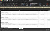
5. modify the values of your SRT file by reading the file on Excel and overwrite all the values for those from AirData log. (To fit in the format of the SRT files I needed to find a way to put values with 5 blank rows in-between and put the same value repeated 3 times on Excel. AirData stores every value by 0.1 sec intervals, while my Mavic 2 produces video caption with all the values by 0.1 x 1/3 sec units)
6. Export the excel file as .txt and modify it so it can be played with your mp4 file. Make sure the whole format is the same

Screenshot 2024-04-23 at 19.39.59.png
Screenshot 2024-04-23 at 20.25.31.png


So it is complicated but not dramatically difficult after I figured out the workflow. If there is no issue I can convert one SRT file in about 10 minutes. My client is happy with the outcomes so I consider it is a success.
 

DJI Drone Deals

New Threads

Forum statistics

Threads
134,485
Messages
1,595,523
Members
163,013
Latest member
GLobus55
Want to Remove this Ad? Simply login or create a free account