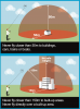
The UK drone code says that you should "Never fly closer than 150m to built-up areas. Never fly directly over a built-up area." It helpfully includes this graphic:

But how is this defined? For example, in Shrewsbury, UK, could I fly my drone at this location, taking off just by the bank of the river and rising above the River Severn? I have highlighted my interpretation of the edges of the built-up area in blue (conservatively, I might add, as one or two of these are properties in relative isolation) and applied a 150 m buffer.
This does leave a clear zone by the red dot. Accepting that it would not be allowed to fly over the public park to the north of this, what about taking the drone off by the bank of the river, going straight up, and moving slightly over the river channel.

Is all of this likely to be permissible? I'm not especially desperate to fly in this location, but am using this as an example. As far as I interpret it, it would be >50 m from private property, >150 m from the built up area.
Thoughts?
But how is this defined? For example, in Shrewsbury, UK, could I fly my drone at this location, taking off just by the bank of the river and rising above the River Severn? I have highlighted my interpretation of the edges of the built-up area in blue (conservatively, I might add, as one or two of these are properties in relative isolation) and applied a 150 m buffer.
This does leave a clear zone by the red dot. Accepting that it would not be allowed to fly over the public park to the north of this, what about taking the drone off by the bank of the river, going straight up, and moving slightly over the river channel.
Is all of this likely to be permissible? I'm not especially desperate to fly in this location, but am using this as an example. As far as I interpret it, it would be >50 m from private property, >150 m from the built up area.
Thoughts?