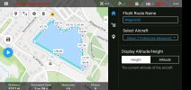
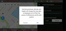
I'm flying a Mavic 2 Enterprise Dual. In DJI Pilot, when using Mission Planning to build a waypoint mission, what is the difference in Height and Altitude when setting RTH, route, and/or waypoint altitudes? The User Manual and DJI video on mission planning don't explain the differences in the two altitude settings. It appears to me that Height is the altitude measured from where the drone took off and Altitude is the altitude measured by barometric pressure from sea level. Because I'm taking off from the top of a parking garage (approx. 60 ft AGL), I want to make sure I understand the differences and set my RTH altitude correctly to clear all nearby obstacles if the drone goes off track for any reason. (I've added a generous buffer to the altitude until I know the difference for sure.)
Thank you very much for the assistance! I'm new to the forum. I apologize if this question has already been asked and answered, but I tried searching for an answer to my question and could not find it.
Thank you very much for the assistance! I'm new to the forum. I apologize if this question has already been asked and answered, but I tried searching for an answer to my question and could not find it.